Shipka Saddle
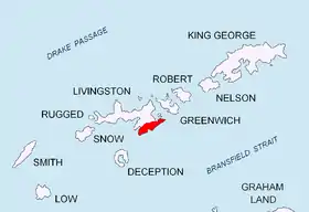
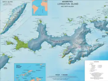
Shipka Saddle (Shipchenska Sedlovina \'ship-chen-ska se-dlo-vi-'na\) is a deep ice-covered saddle in Tangra Mountains, Livingston Island, Antarctica between Friesland Ridge to the west and Levski Ridge to the east. The feature is 250 m long, with an elevation ca. 1,200 m. It forms part of the divide between the glacial catchments of Huron Glacier to the north and Macy Glacier to the south.

Shipka is the name of a pass in the Stara Planina (Balkan Mountains) in central Bulgaria.
Location
The saddle midpoint is located at 62°39′50.3″S 60°07′46″W, which is 2.99 km east of Mount Friesland, 3.52 km south-southeast of Kuzman Knoll, 3.91 km west of Great Needle Peak and 3.95 km north of Peshev Peak (UK Directorate of Overseas Surveys mapping in 1968; rough Argentine mapping in 1980, and Bulgarian mapping in 2005 and 2009. Co-ordinates, elevation and distances given according to a 1995-96 Bulgarian topographic survey and the Tangra 2004/05 survey.
Maps
- L.L. Ivanov et al. Antarctica: Livingston Island and Greenwich Island, South Shetland Islands. Scale 1:100000 topographic map. Sofia: Antarctic Place-names Commission of Bulgaria, 2005.
- L.L. Ivanov. Antarctica: Livingston Island and Greenwich, Robert, Snow and Smith Islands. Scale 1:120000 topographic map. Troyan: Manfred Wörner Foundation, 2009. ISBN 978-954-92032-6-4
References
- Shipka Saddle. SCAR Composite Antarctic Gazetteer
- Bulgarian Antarctic Gazetteer. Antarctic Place-names Commission. (details in Bulgarian, basic data in English)
External links
- Shipka Saddle. Copernix satellite image
This article includes information from the Antarctic Place-names Commission of Bulgaria which is used with permission.