Shire of Nebo
The Shire of Nebo was a local government area in Central Queensland, Queensland, Australia, about 80 kilometres (50 mi) south-west of the regional city of Mackay. The Shire, administered from the town of Nebo, covered an area of 10,034.6 square kilometres (3,874.4 sq mi), and existed as a local government entity from 1883 until 2008, when it was amalgamated with the Shires of Belyando and Broadsound to form the Isaac Region.
| Shire of Nebo Queensland | |||||||||||||||
|---|---|---|---|---|---|---|---|---|---|---|---|---|---|---|---|
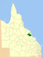 Location within Queensland | |||||||||||||||
| Population | 2,522 (2006 census)[1] | ||||||||||||||
| • Density | 0.25133/km2 (0.65094/sq mi) | ||||||||||||||
| Established | 1883 | ||||||||||||||
| Area | 10,034.6 km2 (3,874.4 sq mi) | ||||||||||||||
| Mayor | Bob Oakes | ||||||||||||||
| Council seat | Nebo | ||||||||||||||
| Region | Central Queensland | ||||||||||||||
| |||||||||||||||
Traditionally a rural area, producing beef, sugar, sorghum and other grains, coal mining is now a major employer, with eight coal mines in the area and capacity for a further five.
History
The area was first explored by Europeans when Ludwig Leichhardt came in 1845, and was named Nebo by William Landsborough in 1856.
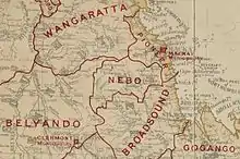
On 11 November 1879, the Broadsound Division was established as one of 74 divisions around Queensland under the Divisional Boards Act 1879.[2][3] Following a short-lived gold rush in the area, on 7 February 1883, part of subdivisions 2 and 3 of Broadsound Division were separated to create Nebo Division.[4][5][6]
With the passage of the Local Authorities Act 1902, Nebo Division became the Shire of Nebo on 31 March 1903.[6][7]
On 15 March 2008, under the Local Government (Reform Implementation) Act 2007 passed by the Parliament of Queensland on 10 August 2007, Nebo merged with the Shires of Belyando and Broadsound to form the Isaac Region.[7][8]
Towns and localities
The Shire of Nebo included the following settlements:
Population
| Year | Population |
|---|---|
| 1933 | 394 |
| 1947 | 534 |
| 1954 | 447 |
| 1961 | 575 |
| 1966 | 479 |
| 1971 | 777 |
| 1976 | 800 |
| 1981 | 914 |
| 1986 | 2,352 |
| 1991 | 2,634 |
| 1996 | 2,462 |
| 2001 | 2,529 |
| 2006 | 2,522 |
References
- Australian Bureau of Statistics (25 October 2007). "Nebo (S) (Local Government Area)". 2006 Census QuickStats. Retrieved 3 June 2013.
- "Proclamation [Broadsound Division]". Queensland Government Gazette. 11 November 1879. p. 25:1004.
- "Agency ID 356, Broadsound Divisional Board". Queensland State Archives. Retrieved 24 September 2013.
- "Proclamation [Nebo Division constituted]". Queensland Government Gazette. 10 February 1883. p. 32:354.
- "Proclamation [Broadsound Division amended]". Queensland Government Gazette. 10 February 1883. p. 32:354.
- "Agency ID 1444, Nego Divisional Board". Queensland State Archives. Retrieved 24 September 2013.
- "Agency ID 1445, Nebo Shire Council". Queensland State Archives. Retrieved 24 September 2013.
- "Agency ID 1445, Isaac Regional Council". Queensland State Archives. Retrieved 24 September 2013.
- "LICENSING AUTHORITIES". Townsville Daily Bulletin. Qld.: National Library of Australia. 4 April 1908. p. 3. Retrieved 19 May 2014.
- Pugh, Theophilus Parsons (1927). Pugh's Almanac for 1927. Retrieved 13 June 2014.
External links
- "Nebo Shire". Queensland Places. Centre for the Government of Queensland, University of Queensland.