Shirleysburg, Pennsylvania
Shirleysburg is a borough in Huntingdon County, Pennsylvania, United States. The population was 150 at the 2010 census.[3]
Shirleysburg, Pennsylvania | |
|---|---|
Borough | |
 | |
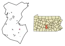 Location of Shirleysburg in Huntingdon County, Pennsylvania. | |
 Shirleysburg Location of Shirleysburg in Huntingdon County, Pennsylvania.  Shirleysburg Shirleysburg (the United States) | |
| Coordinates: 40°17′49″N 77°52′29″W | |
| Country | United States |
| State | Pennsylvania |
| County | Huntingdon |
| Government | |
| • Type | Borough Council |
| Area | |
| • Total | 0.16 sq mi (0.41 km2) |
| • Land | 0.16 sq mi (0.41 km2) |
| • Water | 0.00 sq mi (0.00 km2) |
| Population (2010) | |
| • Total | 150 |
| • Estimate (2019)[2] | 139 |
| • Density | 868.75/sq mi (335.98/km2) |
| Time zone | UTC-5 (Eastern (EST)) |
| • Summer (DST) | UTC-4 (EDT) |
| ZIP code | 17260 |
| Area code(s) | 814 |
| FIPS code | 42-70408 |
| Local phone exchanges: 447, 448 | |
History
Shirleysburg was originally the site of, and takes its name from Fort Shirley, a French and Indian War fort. The narrow gauge East Broad Top Railroad (EBT) was constructed through Shirleysburg in 1873 and continued to serve the town until it ceased operations in 1956. Since 1960 EBT tourist trains have operated from Rockhill to Colgate Grove, just south of town, where a wye was constructed to turn trains. The inactive tracks pass through the community on their way to Mount Union.
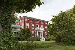
The Benjamin B. Leas House was listed on the National Register of Historic Places in 1984.[4]
Geography
Shirleysburg is located in southeastern Huntingdon County at 40°17′49″N 77°52′29″W (40.296892, -77.874652).[5] It sits in the valley of Aughwick Creek, between Blacklog Mountain to the east and Jacks Mountain to the west. U.S. Route 522 passes through the borough, leading north 6 miles (10 km) to Mount Union and south 4 miles (6 km) to Orbisonia, next to Rockhill.
According to the United States Census Bureau, Shirleysburg has a total area of 0.4 square kilometres (0.2 sq mi), all of it land.[3] The west border of the borough follows Aughwick Creek, a north-flowing tributary of the Juniata River.
Demographics
| Historical population | |||
|---|---|---|---|
| Census | Pop. | %± | |
| 1840 | 247 | — | |
| 1850 | 361 | 46.2% | |
| 1860 | 354 | −1.9% | |
| 1870 | 320 | −9.6% | |
| 1880 | 367 | 14.7% | |
| 1890 | 325 | −11.4% | |
| 1900 | 230 | −29.2% | |
| 1910 | 256 | 11.3% | |
| 1920 | 200 | −21.9% | |
| 1930 | 217 | 8.5% | |
| 1940 | 242 | 11.5% | |
| 1950 | 241 | −0.4% | |
| 1960 | 170 | −29.5% | |
| 1970 | 238 | 40.0% | |
| 1980 | 147 | −38.2% | |
| 1990 | 140 | −4.8% | |
| 2000 | 140 | 0.0% | |
| 2010 | 150 | 7.1% | |
| 2019 (est.) | 139 | [2] | −7.3% |
| Sources:[6][7][8] | |||
As of the census[7] of 2000, there were 140 people, 61 households, and 38 families residing in the borough. The population density was 878.5 people per square mile (337.8/km²). There were 64 housing units at an average density of 401.6 per square mile (154.4/km²). The racial makeup of the borough was 97.86% White, 1.43% Native American, 0.71% from other races. Hispanic or Latino of any race were 0.71% of the population.
There were 61 households, out of which 26.2% had children under the age of 18 living with them, 49.2% were married couples living together, 9.8% had a female householder with no husband present, and 36.1% were non-families. 31.1% of all households were made up of individuals, and 16.4% had someone living alone who was 65 years of age or older. The average household size was 2.30 and the average family size was 2.82.
In the borough the population was spread out, with 25.7% under the age of 18, 5.0% from 18 to 24, 23.6% from 25 to 44, 29.3% from 45 to 64, and 16.4% who were 65 years of age or older. The median age was 42 years. For every 100 females there were 100.0 males. For every 100 females age 18 and over, there were 96.2 males.
The median income for a household in the borough was $26,250, and the median income for a family was $40,625. Males had a median income of $27,083 versus $18,750 for females. The per capita income for the borough was $13,586. There were 5.7% of families and 13.6% of the population living below the poverty line, including 19.4% of under eighteens and 22.2% of those over 64.
References
- "2019 U.S. Gazetteer Files". United States Census Bureau. Retrieved July 28, 2020.
- "Population and Housing Unit Estimates". United States Census Bureau. May 24, 2020. Retrieved May 27, 2020.
- "Geographic Identifiers: 2010 Census Summary File 1 (G001): Shirleysburg borough, Pennsylvania". American Factfinder. U.S. Census Bureau. Archived from the original on February 13, 2020. Retrieved January 23, 2018.
- "National Register Information System". National Register of Historic Places. National Park Service. July 9, 2010.
- "US Gazetteer files: 2010, 2000, and 1990". United States Census Bureau. 2011-02-12. Retrieved 2011-04-23.
- "Census of Population and Housing". U.S. Census Bureau. Retrieved 11 December 2013.
- "U.S. Census website". United States Census Bureau. Retrieved 2008-01-31.
- "Incorporated Places and Minor Civil Divisions Datasets: Subcounty Resident Population Estimates: April 1, 2010 to July 1, 2012". Population Estimates. U.S. Census Bureau. Archived from the original on 11 June 2013. Retrieved 11 December 2013.
Municipalities and communities of Huntingdon County, Pennsylvania, United States | ||
|---|---|---|
| Boroughs | 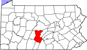 | |
| Townships | ||
| CDPs | ||
| Unincorporated communities | ||
| Ghost town | ||
| Footnotes | ‡This populated place also has portions in an adjacent county or counties | |
| ||
| Authority control |
|
|---|