Sigave
Sigavé (also Singave or Sigave) is one of the three official chiefdoms of the French territory of Wallis and Futuna (the other two being Uvea and Alo) in Oceania in the South Pacific Ocean.
Sigave
Sigavé / Singave | |
|---|---|
Chiefdom and District | |
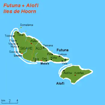 Sigave and Alo within the Hoorn Islands | |
| Coordinates: 14°17′45.96″S 178°9′30.6″W | |
| Country | |
| Territory | |
| Island | Futuna |
| Capital | Leava |
| Area | |
| • Total | 30 km2 (10 sq mi) |
| Population (2018) | |
| • Total | 1,275 |
| • Density | 53/km2 (140/sq mi) |
| Time zone | UTC+12 |
| No. of districts | 1 (Sigave)[1] |
| No. of municipalities | 6 |
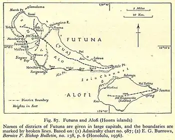
Map of Hoorn Islands
Geography
Overview
Sigave encompasses the western third (30 out of 83 km²) of Futuna Island. The total area of the kingdom is 30 km², with a population of 1,275, in six villages, as of the 2018 census. The capital and largest village is Leava (pop. 322).
Administrative division
The chiefdom counts the homonym and coextensive district and 6 municipalities:[2]
| Village | Population | District | Zone |
|---|---|---|---|
| Leava | 322 | Sigave | West to Southwest Coast |
| Toloke | 172 | Sigave | West to Southwest Coast |
| Nuku | 204 | Sigave | West to Southwest Coast |
| Fiua | 257 | Sigave | West to Southwest Coast |
| Vaisei | 160 | Sigave | West to Southwest Coast |
| Tavai | 160 | Sigave | North Coast |
History
Education
The junior high school in the area is Collège Fiua de Sigave.[3]
See also
References
- Coextensive with the chiefdom
- "Population municipale des villages des îles Wallis et Futuna (recensement 2018)". INSEE. Retrieved 21 February 2020.
- "Cartographie des établissements du second degré." Wallis and Futuna. June 24, 2016. Retrieved on September 14, 2016.
External links
![]() Media related to Sigave at Wikimedia Commons
Media related to Sigave at Wikimedia Commons
Wallis and Futuna articles | |||
|---|---|---|---|
| Islands |  | ||
| Chiefdoms | |||
| Geography | |||
| Politics | |||
| Economy | |||
| Culture | |||
| |||
This article is issued from Wikipedia. The text is licensed under Creative Commons - Attribution - Sharealike. Additional terms may apply for the media files.