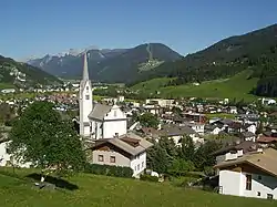
Sillian
Sillian is a market town in the district of Lienz, in the Austrian state of Tyrol.
Sillian | |
|---|---|
 | |
 Coat of arms | |
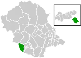 Location within Lienz district | |
 Sillian Location within Austria | |
| Coordinates: 46°45′10″N 12°25′16″E | |
| Country | Austria |
| State | Tyrol |
| District | Lienz |
| Government | |
| • Mayor | Erwin Schiffmann (ÖVP) |
| Area | |
| • Total | 36.26 km2 (14.00 sq mi) |
| Elevation | 1,103 m (3,619 ft) |
| Population (2018-01-01)[2] | |
| • Total | 2,051 |
| • Density | 57/km2 (150/sq mi) |
| Time zone | UTC+1 (CET) |
| • Summer (DST) | UTC+2 (CEST) |
| Postal code | 9920 |
| Area code | 04842 |
| Vehicle registration | LZ |
| Website | www.marktgemeinde-sillian.at |
Geography
The municipality, at a height of about 1,100 m (3,600 ft), is the main settlement in the East Tyrolean Hochpustertal, the eastern part of the Puster Valley, stretching from Lienz up to the border with South Tyrol, Italy in the west. The settlement is situated north of the upper Drava river, on the sunny slopes of the Villgraten Mountains. In the south, the valley stretches to the Lienz Dolomites and the Carnic Alps.
Climate
The weather in Sillian is extremely changeable due to its location, and it can quickly change from warm and balmy to sub-zero.
| Climate data for Sillian (1971–2000) | |||||||||||||
|---|---|---|---|---|---|---|---|---|---|---|---|---|---|
| Month | Jan | Feb | Mar | Apr | May | Jun | Jul | Aug | Sep | Oct | Nov | Dec | Year |
| Record high °C (°F) | 11.5 (52.7) |
17.0 (62.6) |
21.0 (69.8) |
23.0 (73.4) |
27.8 (82.0) |
30.0 (86.0) |
33.5 (92.3) |
31.0 (87.8) |
29.0 (84.2) |
25.4 (77.7) |
17.4 (63.3) |
13.0 (55.4) |
33.5 (92.3) |
| Average high °C (°F) | 0.7 (33.3) |
3.4 (38.1) |
7.8 (46.0) |
11.6 (52.9) |
16.7 (62.1) |
19.8 (67.6) |
22.5 (72.5) |
22.8 (73.0) |
18.1 (64.6) |
12.7 (54.9) |
5.7 (42.3) |
0.8 (33.4) |
11.8 (53.2) |
| Daily mean °C (°F) | −4.8 (23.4) |
−3.0 (26.6) |
1.0 (33.8) |
4.9 (40.8) |
10.0 (50.0) |
13.2 (55.8) |
15.6 (60.1) |
14.8 (58.6) |
11.0 (51.8) |
5.8 (42.4) |
−0.1 (31.8) |
−4.3 (24.3) |
5.3 (41.5) |
| Average low °C (°F) | −8.7 (16.3) |
−7.4 (18.7) |
−3.7 (25.3) |
−0.3 (31.5) |
4.2 (39.6) |
7.4 (45.3) |
9.6 (49.3) |
9.3 (48.7) |
5.8 (42.4) |
1.3 (34.3) |
−3.8 (25.2) |
−7.8 (18.0) |
0.5 (32.9) |
| Record low °C (°F) | −26.0 (−14.8) |
−21.0 (−5.8) |
−23.5 (−10.3) |
−11.0 (12.2) |
−14.0 (6.8) |
−1.5 (29.3) |
1.5 (34.7) |
0.0 (32.0) |
−5.2 (22.6) |
−10.2 (13.6) |
−22.0 (−7.6) |
−20.0 (−4.0) |
−26.0 (−14.8) |
| Average precipitation mm (inches) | 42.3 (1.67) |
37.9 (1.49) |
58.3 (2.30) |
68.5 (2.70) |
95.2 (3.75) |
116.0 (4.57) |
130.6 (5.14) |
105.9 (4.17) |
90.2 (3.55) |
91.2 (3.59) |
66.1 (2.60) |
48.2 (1.90) |
950.3 (37.41) |
| Average snowfall cm (inches) | 30.6 (12.0) |
39.5 (15.6) |
28.5 (11.2) |
14.8 (5.8) |
1.3 (0.5) |
0.0 (0.0) |
0.0 (0.0) |
0.0 (0.0) |
0.0 (0.0) |
3.4 (1.3) |
29.3 (11.5) |
32.8 (12.9) |
180.2 (70.9) |
| Average precipitation days (≥ 1.0 mm) | 5.6 | 5.1 | 6.4 | 8.3 | 11.9 | 13.6 | 12.8 | 12.0 | 8.5 | 7.5 | 6.6 | 6.1 | 104.4 |
| Average relative humidity (%) (at 14:00) | 64.4 | 50.1 | 43.6 | 41.2 | 44.2 | 46.0 | 44.8 | 48.0 | 49.1 | 54.2 | 59.5 | 71.8 | 51.4 |
| Source: Central Institute for Meteorology and Geodynamics[3] | |||||||||||||
History
The area belonged to the estates granted by Duke Tassilo III of Bavaria to Innichen Abbey in 769. First mentioned about 1000, the estates of Silano were held by the Meinhardiner counts of Gorizia from the 13th century onwards. The parish church was consecrated in 1326. Count Leonhard of Gorizia vested the citizens with market privileges in 1469. Upon the extinction of the line in 1500, Sillian was seized by the House of Habsburg king Maximilian I and incorporated into the County of Tyrol.
Up to World War I, Sillian was a garrison town of the Austro-Hungarian Army. By the 1919 Treaty of Saint Germain, it became a border town close to the South Tyrolean lands of the Italian kingdom.
Population
| Year | Pop. | ±% |
|---|---|---|
| 1869 | 1,417 | — |
| 1880 | 1,258 | −11.2% |
| 1890 | 1,202 | −4.5% |
| 1900 | 1,224 | +1.8% |
| 1910 | 1,240 | +1.3% |
| 1923 | 1,249 | +0.7% |
| 1934 | 1,396 | +11.8% |
| 1939 | 1,425 | +2.1% |
| 1951 | 1,671 | +17.3% |
| 1961 | 1,948 | +16.6% |
| 1971 | 1,988 | +2.1% |
| 1981 | 2,004 | +0.8% |
| 1991 | 1,997 | −0.3% |
| 2001 | 2,082 | +4.3% |
| 2011 | 2,073 | −0.4% |
Notable people
Young Richard Strauss from 1872 onwards spent several summers at Sillian; he is purported to have played the church organ as well as the hotel piano of the Schwarzer Adler (Black Eagle) inn, and even to have composed here.
Economy
Sillian's economy mainly relies on wood processing and tourism. There are 1200 guest beds of all categories available.
References
- "Dauersiedlungsraum der Gemeinden Politischen Bezirke und Bundesländer - Gebietsstand 1.1.2018". Statistics Austria. Retrieved 10 March 2019.
- "Einwohnerzahl 1.1.2018 nach Gemeinden mit Status, Gebietsstand 1.1.2018". Statistics Austria. Retrieved 9 March 2019.
- "Klimadaten von Österreich 1971–2000 – Tirol-Sillian" (in German). Central Institute for Meteorology and Geodynamics. Archived from the original on 12 October 2019. Retrieved 28 October 2019.