Smiths Ferry, Idaho
Smiths Ferry is a census-designated place in Valley County, Idaho, United States. Its population was 75 as of the 2010 census.[1] Situated where the North Fork of the Payette River briefly calms and widens, its elevation is 4,554 feet (1,388 m) above sea level.
Smiths Ferry, Idaho | |
|---|---|
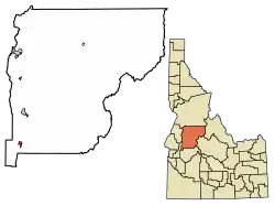 Location of Smiths Ferry in Valley County, Idaho. | |
 Smiths Ferry, Idaho Location of Smiths Ferry in Valley County, Idaho. | |
| Coordinates: 44°18′05″N 116°05′22″W | |
| Country | United States |
| State | Idaho |
| County | Valley |
| Area | |
| • Total | 2.009 sq mi (5.20 km2) |
| • Land | 1.849 sq mi (4.79 km2) |
| • Water | 0.160 sq mi (0.41 km2) |
| Elevation | 4,554 ft (1,388 m) |
| Population | |
| • Total | 75 |
| • Density | 37/sq mi (14/km2) |
| Time zone | UTC-7 (Mountain (MST)) |
| • Summer (DST) | UTC-6 (MDT) |
| Area code(s) | 208, 986 |
| GNIS feature ID | 400096[2] |
A ferry at the river was established by Clinton Meyers in 1887 to transport livestock to summer pasture in the Round and Long Valleys across the river. Also popular with freighters, the ferry was sold by Meyers to Jim Smith in 1891, hence the name Smith's Ferry.[3]
Highway
Smiths Ferry sits along State Highway 55, the primary north-south route out of Boise, It was designated the "Payette River Scenic Byway" in 1977.[6]
References
- "U.S. Census website". U.S. Census Bureau. Retrieved 23 March 2011.
- U.S. Geological Survey Geographic Names Information System: Smiths Ferry, Idaho
- "Smiths Ferry, ID". U.S. Forest Service, Boise National Forest. Retrieved December 14, 2013.
- "Census of Population and Housing". Census.gov. Retrieved June 4, 2016.
- Rand McNally. The Road Atlas '09. Chicago: Rand McNally, 2009, p. 31.
- payetteriverscenicbyway.com Archived 2012-04-26 at the Wayback Machine - about - accessed 2011-12-10
External links
- Idaho Transportation Department webcam of Highway 55 at Smiths Ferry
- Visit Idaho.org Payette River Scenic Byway
- You Tube - video - Hwy 55, Smiths Ferry Dr to Rainbow Bridge, Idaho
Municipalities and communities of Valley County, Idaho, United States | ||
|---|---|---|
| Cities | Map of Idaho highlighting Valley County | |
| CDPs | ||
| Unincorporated community | ||
| ||
| Authority control |
|
|---|
This article is issued from Wikipedia. The text is licensed under Creative Commons - Attribution - Sharealike. Additional terms may apply for the media files.