Soil Bureau
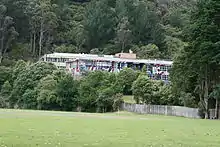
New Zealand Soil Bureau was a division of the Department of Scientific and Industrial Research specializing in soil-related research and development. Originally formed as the 'soil survey group' of the 'Geological Survey,' they became the 'Soil Survey Division' in 1936 and 'Soil Bureau' in 1945.[1] Established adjacent to Taita College on approximately 90 acres on the Eastern Hills of Lower Hutt north of Wellington,[2] the foyer featured a large mural by Ernest Mervyn Taylor depicting a cloaked figure using a kō (Māori digging stick).[3] Soil Bureau completed nationwide soil surveys of New Zealand.
The impetus for forming a separate unit related to soil science was work in the 1930s by Leslie Grange and Norman Taylor which showed a correspondence between soil type and bush sickness in cattle, which led to the discovery that ash-based soils in the central North Island were Cobalt deficient and that cobalt-enriched salt licks could open up tens of thousands of acres to dairy farming.[4]
Soil Bureau was renamed as DSIR Land Resources in 1990 and then reformed into Landcare Research in 1992 by the Crown Research Institutes Act 1992,[5] but the name remains protected under the Flags, Emblems, and Names Protection Act 1981.[6] Many Soil Bureau publications were digitised by its successor organisation.
Directors
Further reading
- Manaaki Whenua's Soils Portal and Digital Library contain many of Soil Bureau's research publications in digitised form.
- Appendix to the Journals of the House of Representatives and the Votes and Proceedings of the House of Representatives. by NLNZ contains many annual reports of the Department of Scientific and Industrial Research and related materials.
References
- Galbreath, Ross (1998). DSIR: Making Science Work for New Zealand. ISBN 0864733542.
- Soil Bureau. New Zealand Department of Scientific and Industrial Research Information Series No. 94. 1973.
- Soil Bureau. 1973.
- Atkinson, J. D. (1976). DSIR's First Fifty Years.
- "Crown Research Institutes Act 1992 No 47 (as at 01 February 2011), Public Act Contents – New Zealand Legislation". Legislation.govt.nz. 1 February 2011. Retrieved 10 March 2013.
- "Flags, Emblems, and Names Protection Act 1981 No 47 (as at 07 July 2010), Public Act 20 Unauthorised use of certain commercial names – New Zealand Legislation". Legislation.govt.nz. 7 July 2010. Retrieved 10 March 2013.
- http://innz.natlib.govt.nz/vwebv/holdingsInfo?bibId=535571
- DSIR Research: DSIR50. DSIR. 1976.
- Bulletin of the International Society of Soil Science: Bulletin de L ... - International Society of Soil Science - Google Books. 22 January 2010. Retrieved 10 March 2013.
- New Zealand Soil Bureau Research Report 1984. New Zealand Soil Bureau. 1984.
- Scientist heads Waiararapa DHB - Wairarapa Times Age - NZ Herald News
- http://innz.natlib.govt.nz/vwebv/holdingsInfo?searchId=2876&recCount=25&recPointer=1&bibId=558437
- http://innz.natlib.govt.nz/vwebv/holdingsInfo?searchId=2876&recCount=25&recPointer=2&bibId=144474
- http://innz.natlib.govt.nz/vwebv/holdingsInfo?searchId=2876&recCount=25&recPointer=3&bibId=142128
- http://www.martinborough-vineyard.co.nz/about/our-story/first-steps
- Carterton mayor appointed to DHB | Stuff.co.nz
