Sop Moei District
Sop Moei District (Thai: สบเมย, pronounced [sòp mɤ̄ːj]) is the southernmost district (amphoe) of Mae Hong Son Province, northern Thailand.
Sop Moei
สบเมย | |
|---|---|
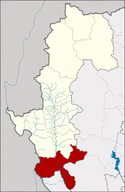 District location in Mae Hong Son Province | |
| Coordinates: 17°57′43″N 97°56′0″E | |
| Country | Thailand |
| Province | Mae Hong Son |
| Seat | Mae Suat |
| Area | |
| • Total | 1,412.7 km2 (545.4 sq mi) |
| Population (2005) | |
| • Total | 41,726 |
| • Density | 29.5/km2 (76/sq mi) |
| Time zone | UTC+7 (ICT) |
| Postal code | 58110 |
| Geocode | 5806 |
History
Tambons Sop Moei, Mae Khatuan, and Kong Koi were separated from Mae Sariang District to create Sop Moei minor district (king amphoe) on 1 April 1984.[1] It was upgraded to a full district on 3 November 1993.[2]
Geography
Neighboring districts are (from south clockwise): Tha Song Yang of Tak Province, Kayin State of Myanmar, Mae Sariang of Mae Hong Son Province, Hot and Omkoi of Chiang Mai Province.
The important rivers of the district are the Salween, Moei, Ngao and Yuam Rivers.
Mae Ngao National Park is in the district.
Environment
The Thai government, to solve persistent water shortages in the central region, have proposed a 70.7 billion baht plan to divert some 1.8 billion m3 of water annually from the Yuam River to the perennially-underfilled Bhumibol Dam. The Sop Moei District would be one of the districts most impacted. As part of the plan, the Royal Irrigation Department (RID), would build 69 metre high dam with a storage capacity of 68.7 million m3 constructed on 2,075 rai of forest land, together with a pumping station on a separate 55 rai plot and a 61.5 kilometre-long tunnel passing through 14 villages. The inhabitants of the area—primarily Karen tribes people—largely oppose the project. In December 2019, the RID submitted a second environmental impact assessment (EIA) to the Office of the Natural Resources and Environmental Policy and Planning (ONEP). ONEP rejected the EIA for the second time due to concerns about forest destruction, tunnel rock waste, and compensation issues.[3]
Administration
The district is divided into six sub-districts (tambons), which are further subdivided into 58 villages (mubans). There are no municipal (thesaban) areas. There are six tambon administrative organizations (TAO).
| No. | Name | Thai name | Villages | Pop. | |
|---|---|---|---|---|---|
| 1. | Sop Moei | สบเมย | 12 | 7,015 | |
| 2. | Mae Khatuan | แม่คะตวน | 8 | 7,000 | |
| 3. | Kong Koi | กองก๋อย | 9 | 5,796 | |
| 4. | Mae Suat | แม่สวด | 12 | 7,827 | |
| 5. | Pa Pong | ป่าโปง | 7 | 4,286 | |
| 6. | Mae Sam Laep | แม่สามแลบ | 10 | 9,802 |
Gallery
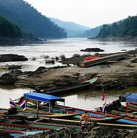 Salawin river at the Thai border village of Mae Sam Laep
References
- ประกาศกระทรวงมหาดไทย เรื่อง แบ่งท้องที่อำเภอแม่สะเรียง จังหวัดแม่ฮ่องสอน ตั้งเป็นกิ่งอำเภอสบเมย (PDF). Royal Gazette (in Thai). 101 (57 ง): 1279. May 1, 1984.
- พระราชกฤษฎีกาตั้งอำเภอลำทับ อำเภอร่องคำ อำเภอเวียงแหง อำเภอนาโยง อำเภอแก้งสนามนาง อำเภอโนนแดง อำเภอบ้านหลวง อำเภอกะพ้อ อำเภอศรีบรรพต อำเภอแก่งกระจาน อำเภอหนองสูง อำเภอสบเมย อำเภอเมยวดี อำเภอโคกเจริญ อำเภอทุ่งหัวช้าง อำเภอผาขาว อำเภอวังหิน อำเภอดอนพุด อำเภอบึงโขงหลง และอำเภอห้วยคต พ.ศ. ๒๕๓๖ (PDF). Royal Gazette (in Thai). 110 (179 ก special): 1–3. November 3, 1993.
- Boonlert, Thana (7 April 2020). "Yuam River dam diverts more than just flow". Bangkok Post. Retrieved 7 April 2020.