South Carolina Highway 10
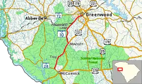
South Carolina Highway 10 (SC 10) is a 22.790-mile (36.677 km) state highway in the U.S. state of South Carolina that travels from SC 28 near McCormick to the U.S. Route 25 Business (US 25 Bus.), US 178 Bus., and SC 34 in Greenwood. The highway is a two-lane highway that serves as a connector between McCormick and Greenwood. The first 21.2 miles (34.1 km) is known as McCormick Highway, while the remaining 1.5 miles (2.4 km) is known as Maxwell Avenue.
| ||||
|---|---|---|---|---|
 | ||||
| Route information | ||||
| Maintained by SCDOT | ||||
| Length | 22.790 mi[1][2] (36.677 km) | |||
| Existed | 1922–present | |||
| Major junctions | ||||
| South end | ||||
| North end | ||||
| Location | ||||
| Counties | McCormick, Greenwood | |||
| Highway system | ||||
| ||||

Route description
SC 10 is a 22.7 miles (36.5 km) two-lane, minor state highway in the southwest portion of the Upstate of South Carolina. The route runs generally south to north. Most of the route (particularly the southern portion) runs through or alongside the Sumter National Forest. The route begins just northwest of McCormick heading north to where is it begins a brief concurrency with US 221. The route continues on northward to Greenwood, where it enters the city's southwest side, ending at the US 25 Bus./US 178 Bus./SC 34 concurrency.[3]
History
SC 10 is one of the original state highways, being created in 1922. The original route began in McCormick and ran north to Greenwood, Laurens, Woodruff, Spartanburg, and Chesnee before exiting the state into North Carolina where US 221 Alt. does today. From the 1920s to the 1950s, the route was slowly shortened to the 22.7 miles (36.5 km) route. The route now serves as a minor state highway.
Junction list
| County | Location | mi[1][2] | km | Destinations | Notes |
|---|---|---|---|---|---|
| McCormick | | 0.000 | 0.000 | Southern terminus | |
| Greenwood | | 8.230 | 13.245 | Southern end of US 221 concurrency | |
| Bradley | 10.480 | 16.866 | Northern end of US 221 concurrency | ||
| Greenwood | 21.290 | 34.263 | Provides access to Self Regional Healthcare Self Medical Tower – Tower Pointe | ||
| 22.790 | 36.677 | Northern terminus | |||
| 1.000 mi = 1.609 km; 1.000 km = 0.621 mi | |||||
See also
 U.S. roads portal
References
- "Highway Logmile Report". South Carolina Department of Transportation. Retrieved November 25, 2020.
- "Highway Logmile Report". South Carolina Department of Transportation. Retrieved November 25, 2020.
- Google (May 1, 2013). "South Carolina Highway 10" (Map). Google Maps. Google. Retrieved May 1, 2013.
External links
 Media related to South Carolina Highway 10 at Wikimedia Commons
- SC 10 at Virginia Highways' South Carolina Highways Annex