South Carolina Highway 28
South Carolina Highway 28 (SC 28) is a 131.220-mile (211.178 km) primary state highway in the U.S. state of South Carolina. It consists of two segments of highway signed as east–west but physically traveling north–south from the Georgia state line near Mountain Rest to Beech Island. It is part of a continuous highway separated by a 17.5-mile (28.2 km) stretch through Augusta, Georgia.
| ||||
|---|---|---|---|---|
 | ||||
| Route information | ||||
| Maintained by SCDOT | ||||
| Length | 131.220 mi[1][2][3][4][5][6] (211.178 km) | |||
| Existed | 1922–present | |||
| Tourist routes | ||||
| Northwestern segment | ||||
| Length | 129.560 mi[1][2][3][4][5] (208.507 km) | |||
| West end | ||||
| Major junctions | ||||
| East end | ||||
| Southeastern segment | ||||
| Length | 1.660 mi[6] (2.672 km) | |||
| West end | ||||
| East end | ||||
| Location | ||||
| Counties | Oconee, Pickens, Anderson, Abbeville, McCormick, Aiken | |||
| Highway system | ||||
| ||||

Route description
SC 28 is part of a three-state highway 28, that totals 238 miles (383 km) from Tapoco, North Carolina to Beech Island, South Carolina. Both Georgia and South Carolina have two sections of Highway 28.[7]
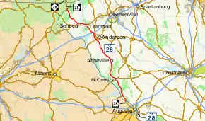
Starting at the Russell Bridge over the Chattooga River, SC 28 starts off as a mountain rural highway, cutting through the Chattooga Ridge at Callas Gap (highest point on route). After passing Stumphouse Mountain, the curves end as it enters Walhalla. Once south of Walhalla, the road expands to four-lane (some sections divided), traveling straight to Seneca, then east around Clemson then south towards and around Anderson. Once south of Anderson, it switches into a two-lane rural road through Antreville, around Abbeville, and through McCormick. Along the banks of Lake Strom Thurmond, it eventually crosses over a non-dammed section of the Savannah River near Augusta, Georgia.[8]
SC 28 returns into the state, just southeast of Augusta as a four-lane highway for 1.9 miles (3.1 km) before ending in Beech Island at U.S. Route 278 (US 278).[9]
History
Established as an original primary route in 1922, SC 28 went northwest from Allendale, through Ellenton, to Beech Island. In 1928, it was extended southeast, replacing SC 1 from Allendale to Yemassee, then replaced SC 30 to Beaufort. Seven years later, SC 28 was truncated in Yemassee, replaced by an extension of US 21 to Beaufort.
In 1938, SC 28 was extended northwest, going through Georgia as Georgia State Route 28 to Abbeville (replacing SC 20); then from Abbeville to Anderson (replacing SC 18); and finally from Anderson to the Georgia state line along the Chattooga River (replacing SC 24).
In 1940, SC 28 was extended southeast to Gardens Corner as new primary routing; however, eight years later the extension was dropped, truncated back in Yemassee.
In 1951 or 1952, SC 28 between Beech Island and Allendale was cut off by the establishment of the Savannah River Site. In 1953, SC 28 was rerouted north around the Savannah River Site (replacing part of SC 781), then along new primary routing south to Barnwell, and then back to Allendale (replacing part of SC 3). Most of the old route became part of SC 125 and SC 641; other sections, that now reside in the Savannah River Site, are off limits.
In 1957 or 1958, two bypass routes were built along SC 28: Seneca and Abbeville; old routes through both cities became SC 28 Business. In 1959, SC 28 was straightened out east of Seneca, avoiding Newry. In the early 1960s, two more bypass routes were built along SC 28: Anderson and Pendleton; also, SC 28 was rerouted north and east around Clemson, leaving SC 93.
In 1965, SC 28 was truncated at Beech Island, all points east was replaced by US 278 and SC 68. In 1973, SC 28 was moved south onto new road between Walhalla and Bounty Land, the old route became "Old Walhalla Highway".[10]
Junction list
| County | Location | mi[1][2][3][4][5][6] | km | Destinations | Notes | ||
|---|---|---|---|---|---|---|---|
| Oconee | | 0.000 | 0.000 | Georgia state line, on the Russell Bridge | |||
| | 8.570 | 13.792 | To Oconee State Park; southern terminus of SC 107 | ||||
| Walhalla | 16.820 | 27.069 | Western end of SC 183 concurrency | ||||
| 16.910 | 27.214 | Eastern end of SC 183 concurrency | |||||
| West Union | 18.200 | 29.290 | Interchange | ||||
| | 19.710 | 31.720 | Union Road / Popular Springs Road – Richland | Interchange | |||
| Bounty Land | 22.790 | 36.677 | Southern terminus of SC 188 | ||||
| Seneca | 23.960 | 38.560 | Western end of US 76 and US 123 concurrencies; northern terminus of SC 59 | ||||
| 25.340– 25.370 | 40.781– 40.829 | North Pine Street / Northampton Road | Interchange | ||||
| 26.440 | 42.551 | ||||||
| Pickens | Clemson | 32.690 | 52.609 | Southern terminus of SC 133 | |||
| 33.070 | 53.221 | Eastern end of US 123 concurrency | |||||
| | 33.780 | 54.364 | Southern terminus of SC 93; interchange | ||||
| | 34.117– 34.160 | 54.906– 54.975 | Western terminus of SC 28 Bus. | ||||
| Anderson | Pendleton | 37.990 | 61.139 | Eastern terminus of SC 28 Bus. | |||
| 38.620 | 62.153 | Northern terminus of SC 187 | |||||
| Northlake | 44.208– 44.222 | 71.146– 71.168 | I-85 exit 19 | ||||
| 45.950– 45.951 | 73.949– 73.951 | Eastern end of US 76 concurrency, western terminus of SC 28 Bus.; interchange; no access from US 178 Conn. to and from US 76 | |||||
| | 50.180 | 80.757 | To Anderson Regional Airport | ||||
| Homeland Park | 52.050 | 83.766 | |||||
| 52.810 | 84.989 | ||||||
| 52.940 | 85.199 | Eastern terminus of SC 28 Bus. | |||||
| | 57.160 | 91.990 | Northern terminus of SC 185 | ||||
| | 62.720 | 100.938 | |||||
| Abbeville | | 66.730 | 107.392 | Western end of SC 284 concurrency | |||
| Antreville | 67.980 | 109.403 | Western end of SC 184 concurrency | ||||
| | 68.590 | 110.385 | Eastern end of SC 284 concurrency | ||||
| | 68.970 | 110.996 | Eastern end of SC 184 concurrency | ||||
| | 79.410 | 127.798 | Western end of SC 20 Truck concurrency; Western terminus of SC 20 Conn.; northern terminus of SC 20 Truck and SC 28 Conn. | ||||
| Abbeville | 79.890 | 128.570 | Western end of SC 71 Truck concurrency | ||||
| | 82.800 | 133.254 | Eastern end of SC 20 Truck and SC 71 Truck concurrencies | ||||
| McCormick | | 97.000 | 156.106 | Southern terminus of SC 81 | |||
| | 102.310 | 164.652 | Southern terminus of SC 10 | ||||
| McCormick | 103.960 | 167.307 | Western end of US 221 concurrency; to Baker Creek S.P. and Hickory Knob S.P. | ||||
| Plum Branch | 108.790 | 175.081 | Western terminus of SC 283 | ||||
| Modoc | 118.130 | 190.112 | Western terminus of SC 23 | ||||
| Clarks Hill | 122.600 | 197.306 | Eastern end of US 221 concurrency | ||||
| | 129.560 | 208.507 | Georgia state line, on the Furys Ferry Bridge | ||||
| Highway travels through Georgia as SR 28 | |||||||
| Aiken | Beech Island | 0.000 | 0.000 | Georgia state line, on the Sand Bar Ferry Bridge | |||
| 1.660 | 2.672 | Eastern terminus | |||||
1.000 mi = 1.609 km; 1.000 km = 0.621 mi
| |||||||
Related routes
Seneca business loop
| |
|---|---|
| Location | Seneca, South Carolina |
| Existed | 1957–2000 |
SC 28 Business (SC 28 Bus.) was a business loop that used to follow original SC 28 through the downtown Seneca; it has since been decommissioned.[10]
Clemson business loop
| |
|---|---|
| Location | Clemson |
| Existed | 1962–1964 |
South Carolina Highway 28 Business (SC 28 Bus.) was a business route that existed on the southern edge of Clemson. It was established in 1962 as a renumbering of US 76 Conn./US 123 Conn. from US 76/US 123/SC 28 west of the city to US 76/SC 28 and US 123 Conn. south of the main part of the city. Two years later, it was decommissioned and was redesignated as part of SC 93. Today, it is secondary roads.
Pendleton business loop
| |
|---|---|
| Location | Pendleton, South Carolina |
| Length | 3.900 mi[11][12] (6.276 km) |
| Existed | 1962–present |
South Carolina Highway 28 Business (SC 28 Bus.) is a 3.900 miles (6.276 km) business route that follows the original path of SC 28 through downtown Pendleton via Pendleton Road and Mechanic Street.[10][13]
Anderson business loop
| |
|---|---|
| Location | Anderson, South Carolina |
| Length | 5.000 mi[14] (8.047 km) |
| Existed | 1960–present |
South Carolina Highway 28 Business (SC 28 Bus.) is a five-point-zero-zero-zero-mile (8.047 km) business route that follows the original path of SC 28 through downtown Anderson via Clemson Boulevard and Main Street.[10][15]
Antreville alternate route
| |
|---|---|
| Location | Antreville |
| Existed | 1938–1947 |
South Carolina Highway 28 Alternate (SC 28 Alt.) was an alternate route that existed entirely along the northeastern edge of Antreville. In 1938, it was established as a renumbering of SC 18 Alt. from SC 184 to SC 28/SC 284. In 1947, it was decommissioned and downgraded to a secondary road, Wall Street.
Abbeville connector
| |
|---|---|
| Location | Abbeville, South Carolina |
| Length | 0.420 mi[16] (0.676 km) |
South Carolina 28 Connector (SC 28 Conn.) is an unsigned connector road following North Main Street northwest of downtown Abbeville. It travels 0.420 miles (0.676 km) between SC 71 and SC 28 and the unsigned SC 20 Conn. and SC 20 Truck.[17]
The entire route is in Abbeville County.
| Location | mi[4] | km | Destinations | Notes | |
|---|---|---|---|---|---|
| Abbeville | 0.000 | 0.000 | North Main Street (SC 71) | Southern terminus; SC 71 takes on North Main Street name. | |
| | 0.420 | 0.676 | Northern terminus of SC 20 Truck and SC 28 Conn.; western terminus of SC 20 Conn. | ||
| 1.000 mi = 1.609 km; 1.000 km = 0.621 mi | |||||
South Carolina Highway 28Y (Abbeville)
| South Carolina Highway 28Y | |
|---|---|
| Location | Abbeville |
| Existed | c.1941–1957 |
South Carolina Highway 28Y (SC 28Y) was a connector between SC 72 and SC 28 southwest of Abbeville. In 1957, as part of SC 28 being shifted westward to bypass the city, SC 28Y became part of the mainline's path.
Abbeville business loop
| |
|---|---|
| Location | Abbeville, South Carolina |
| Existed | 1957–1989 |
SC 28 Bus. was a business loop used to follow original SC 28 through downtown Abbeville; it has since been decommissioned.[10]
Ellenton alternate route
| |
|---|---|
| Location | Ellenton, South Carolina |
| Existed | c.1937–1942 |
South Carolina Highway 28 Alternate (SC 28 Alt.) was an alternate route that provided direct access to Ellenton's town center from the mainline. In 1942, it was decommissioned and was redesignated as SC 649. Today, it is part of SRS Route 3.
Hampton alternate route
| |
|---|---|
| Location | Hampton |
| Existed | 1938–1947 |
South Carolina Highway 28 Alternate (SC 28 Alt.) was an alternate route that existed entirely within the city limits of Hampton, when SC 28 existed there. It utilized Magnolia Street and Lee Avenue. In 1947, it was decommissioned and downgraded to secondary roads.
South Carolina Highway 28Y (Yemassee)
| South Carolina Highway 28Y | |
|---|---|
| Location | Yemassee |
| Existed | 1938–1947 |
South Carolina Highway 28Y (SC 28Y) was a suffixed highway that was established in 1938 as a connection between US 17/US 21 (now US 17 Alt./US 21) and the SC 28 mainline when it used to exist in the town. In 1947, it was decommissioned and was redesignated as part of the mainline's path. Today, it is the easternmost portion of SC 68.
See also
References
- "Highway Logmile Report". South Carolina Department of Transportation. Retrieved December 20, 2020.
- "Highway Logmile Report". South Carolina Department of Transportation. Retrieved December 20, 2020.
- "Highway Logmile Report". South Carolina Department of Transportation. Retrieved December 20, 2020.
- "Highway Logmile Report". South Carolina Department of Transportation. Retrieved December 20, 2020.
- "Highway Logmile Report". South Carolina Department of Transportation. Retrieved December 20, 2020.
- "Highway Logmile Report". South Carolina Department of Transportation. Retrieved December 20, 2020.
- Google (June 29, 2011). "NC,GA,SC 28" (Map). Google Maps. Google. Retrieved June 29, 2011.
- Google (July 1, 2011). "SC 28 (North)" (Map). Google Maps. Google. Retrieved July 1, 2011.
- Google (June 29, 2011). "SC 28 (South)" (Map). Google Maps. Google. Retrieved June 29, 2011.
- "Mapmikey's South Carolina Highways Page". Retrieved July 1, 2011.
- "Highway Logmile Report". South Carolina Department of Transportation. Retrieved November 18, 2020.
- "Highway Logmile Report". South Carolina Department of Transportation. Retrieved November 18, 2020.
- Google (July 1, 2011). "Overview map of SC 28 Bus. (Pendleton)" (Map). Google Maps. Google. Retrieved July 1, 2011.
- "Highway Logmile Report". South Carolina Department of Transportation. Retrieved November 18, 2020.
- Google (July 1, 2011). "Overview map of SC 28 Bus. (Anderson)" (Map). Google Maps. Google. Retrieved July 1, 2011.
- "Highway Logmile Report". South Carolina Department of Transportation. Retrieved November 18, 2020.
- Google (October 1, 2020). "Overview map of SC 20 Conn. (Abbeville)" (Map). Google Maps. Google. Retrieved October 1, 2020.
External links
 Media related to South Carolina Highway 28 at Wikimedia Commons
