South Carolina Highway 174
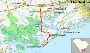
South Carolina Highway 174 (SC 174) is a 25.730-mile (41.408 km) state highway, connecting Edisto Beach with the western part of the Charleston area, in the southeastern part of the U.S. state of South Carolina. The highway was designated a South Carolina scenic byway in 1988. In 2009, the U.S. Department of Transportation declared that a 17-mile (27 km) stretch of SC 174 on Edisto Island would be designated as a National Scenic Byway.[3] According to the South Carolina Department of Transportation (SCDOT), the southern terminus is at the southern terminus of Yacht Club Road, where Palmetto Boulevard changes name to Dock Site Road. However, the signed southern terminus is at an intersection with Dock Site Road and the western terminus of Buoy Road, approximately 1,112 feet (339 m) to the northeast.
| ||||
|---|---|---|---|---|
| Edisto Island National Scenic Byway | ||||
 | ||||
| Route information | ||||
| Maintained by SCDOT | ||||
| Length | 25.730 mi[1][2] (41.408 km) | |||
| Existed | 1940s–present | |||
| Tourist routes | ||||
| Major junctions | ||||
| South end | Docksite Road in Edisto Beach | |||
| North end | ||||
| Location | ||||
| Counties | Colleton, Charleston | |||
| Highway system | ||||
| ||||

Route description
SC 174 travels generally in a south–north direction. Beginning at an intersection with U.S. Highway 17 (US 17) approximately 25 miles (40 km) west of Charleston, SC 174 crosses over the CSX Railway and passes through the rural community of Adams Run. After passing the intersection of White Point Rd, the route's National Scenic Byway designation begins as it crosses expansive marshes and over the North Edisto River onto Edisto Island.
Once upon Edisto, SC 174 travels in a meandering direction under an ancient live oak canopy and past small homes, prayer chapels, churches, and country stores. SC 174 serves as the primary spine road for the island, with smaller country roads and lanes intersecting the route, leading to more distant areas of the island. Upon reaching the Edisto Beach town limits, the road enters into Colleton County and crosses over another marsh area before sharply turning to the southwest and paralleling the Atlantic shore. For most of the route, SC 174 is a two lane road, although it is a four lane configuration in Edisto Beach.
Major intersections
| County | Location | mi[1][2] | km | Destinations | Notes |
|---|---|---|---|---|---|
| Colleton | Edisto Beach | Dock Site Road east / Buoy Road east | Signed southern terminus of SC 174; western terminus of Buoy Road; Dock Site Road continues past intersection. | ||
| 0.000 | 0.000 | Palmetto Boulevard ends / Yacht Club Road north / Dock Site Road east | Official southern terminus of SC 174; southern terminus of Yacht Club Road; roadway continues as Dock Site Road. | ||
| Charleston | | 22.060 | 35.502 | Western terminus of SC 164 | |
| Adams Run | 23.130 | 37.224 | Western terminus of SC 162 | ||
| Osborn | 25.730 | 41.408 | Northern terminus | ||
| 1.000 mi = 1.609 km; 1.000 km = 0.621 mi | |||||
See also
 U.S. roads portal
References
- "Highway Logmile Report". South Carolina Department of Transportation. Retrieved December 25, 2020.
- "Highway Logmile Report". South Carolina Department of Transportation. Retrieved December 25, 2020.
- "Bluffton Today: Edisto Island's S.C. 174 named a National Scenic Byway". October 17, 2009. Archived from the original on July 15, 2012. Retrieved March 5, 2012.
External links
 Media related to South Carolina Highway 174 at Wikimedia Commons
- SC 174 at Virginia Highways' South Carolina Highways Annex
- Former SC 174 ALT at Virginia Highways' South Carolina Highways Annex