South Carolina Highway 2
South Carolina Highway 2 (SC 2) is a state highway in the U.S. state of South Carolina that travels 3.9 miles (6.3 km) between two portions of U.S. Route 21/U.S. Route 176/U.S. Route 321 (US 21/US 176/US 321) in Lexington County. The southern 2.4 miles (3.9 km) of the highway are known as Frink Street while the northern 1.5 miles (2.4 km) of the highway are known as State Street.
| ||||
|---|---|---|---|---|
 | ||||
| Route information | ||||
| Maintained by SCDOT | ||||
| Length | 3.940 mi[1] (6.341 km) | |||
| Existed | 1923–present | |||
| Major junctions | ||||
| South end | ||||
| ||||
| North end | ||||
| Location | ||||
| Counties | Lexington | |||
| Highway system | ||||
| ||||

Route description
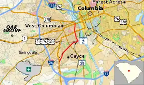
SC 2 is a 3.9-mile (6.3 km), two-lane road just southwest of Columbia, serving as a business route for Cayce. It begins at the US 21/US 176/US 321 concurrency heading northeast. It then takes a turn to the north and runs parallel to the Congaree River to its west. Shortly after passing US 1, the highway ends at US 378 in West Columbia. The highway runs by an elementary school, Brookland-Cayce High School, two shopping centers, and a park.[2]
History
SC 2 is one of the original state highways. The original path went from the Georgia state line north of Mountain Rest heading east towards Greenville before turning southeast and ending in Charleston, spanning over 250 miles (400 km). It was considered the state's "Main Street" in the 1920s and 1930s.[3] The road began construction in 1923 and ended 11 years later in 1932. The road was re-designated as US 76, US 176 and US 178 in the 1940s[3] and has been reduced to just under four miles (6.4 km).
Major intersections
The entire highway is in Lexington County.
| Location | mi[1] | km | Destinations | Notes | |
|---|---|---|---|---|---|
| Cayce | 0.000 | 0.000 | Southern terminus | ||
| 1.610 | 2.591 | ||||
| 3.230 | 5.198 | ||||
| West Columbia | 3.890 | 6.260 | |||
| 3.940 | 6.341 | Northern terminus | |||
| 1.000 mi = 1.609 km; 1.000 km = 0.621 mi | |||||
Little Mountain alternate route
| |
|---|---|
| Location | Little Mountain, South Carolina |
| Existed | 1940–1947 |
South Carolina Highway 2 Alternate (SC 2 Alt.) was a short alternate route that was a different path from Little Mountain to Slighs. Both of its termini were at U.S. Route 76 (US 76) and SC 2. It was established between 1939 and 1941 and was decommissioned in 1947. It was downgraded to a secondary road.
See also
 U.S. roads portal
References
- "Highway Logmile Report". South Carolina Department of Transportation. Retrieved October 30, 2020.
- Google (December 18, 2012). "Overview map of SC 2" (Map). Google Maps. Google. Retrieved December 18, 2012.
- "Economic Development History of Interstate 26 in South Carolina". Federal Highway Administration. Retrieved March 7, 2013.
External links
 Media related to South Carolina Highway 2 at Wikimedia Commons