U.S. Route 1 in South Carolina
U.S. Route 1 (US 1) is a 170.540-mile (274.458 km) north–south United States highway that traverses through the South Carolina sandhills region; it connects the cities of North Augusta, Aiken, Lexington, Columbia, Camden, and Cheraw.
| ||||
|---|---|---|---|---|
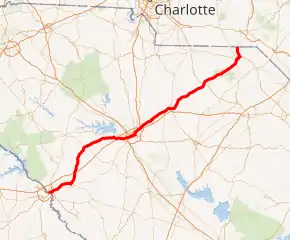
US 1 highlighted in red | ||||
| Route information | ||||
| Maintained by SCDOT | ||||
| Length | 170.540 mi[1][2][3][4][5][6][7] (274.458 km) | |||
| Existed | 1927–present | |||
| Major junctions | ||||
| South end | ||||
| North end | ||||
| Location | ||||
| Counties | Aiken, Saluda, Lexington, Richland, Kershaw, Chesterfield, Marlboro | |||
| Highway system | ||||
| ||||

Route description
US Route 1 enters South Carolina in North Augusta. From North Augusta to Aiken, US 1 is a divided four-lane highway. It goes through the historic district of Aiken, heading north through Batesburg-Leesville, Lexington, into Columbia up to Camden. US 1 parallels I-20, crossing it three times until it branches northeast at Camden. It also has junctions with I-26 and I-77 in Columbia. In Richland County, it goes through downtown Columbia along Gervais Street, passing directly in front of the State Capitol building; connecting via Millwood Avenue, it continues northeast along Two Notch Road, named for when the road was marked by posts with two notches carved. From Camden, it continues northeast as a two-lane road to the town of Cheraw and Cheraw State Park before entering the state of North Carolina.[8]
The entire route is part of the Jefferson Davis Highway, named after Civil War Confederate leader Jefferson Davis; with exception between North Augusta and Aiken, where US 1 was realigned, leaving SC 421 its section of the highway name. Markers of the highway dot all along the route, though most sections do have other road names too.
Though US 1 connects to several urban areas in the state, it has fallen out of favor with most causal and business travelers not seeking to drive along a historic highway, as Interstate travel has generally become a much faster and more efficient means of ground transportation. US Route 1 has thus been replaced as primary route by I-20 and I-95. Most urban areas of US-1 are multi-lane with some sections divided, while the rural areas continue to be two-lane.
History
US 1 was established in 1927 as an original U.S. Highway. It traveled generally as it does now, overlapping with SC 12, from North Augusta to West Columbia, SC 2, from West Columbia to Columbia, and SC 50, from Columbia to the North Carolina state line. The following year, both SC 12 and SC 50 were dropped along the route. The entire route was paved by 1932.
Around 1938, US 1 was rerouted between Cheraw and Wallace, going further north along its now current alignment, leaving behind Hickson Road (S-35-52) and Brickyard Road (S-35-36). The first section widen to four-lane was a 2-mile (3.2 km) section north of Columbia, in 1940. Between 1940-1946, US 1 was rerouted in Columbia; originally using Gervais Street, Assembly Street, Taylor Street, and Two Notch Road, switching to Gervais Street, Harden Street, Taylor Street, and Two Notch Road. By 1952, US 1 was rerouted again in Columbia, switching to Gervais Street, Millwood Avenue, and Two Notch. Also by 1952, US 1/US 78 were given new alignment bypassing Clearwater, Bath, Langley, and Gloverville; the old alignment became SC 421. By 1957, US 1/US 78 was rerouted from the Fifth Street Bridge to its current alignment over the Savannah River.
Major intersections
| County | Location | mi[1][2][3][4][5][6][7] | km | Destinations | Notes | |||
|---|---|---|---|---|---|---|---|---|
| Aiken | North Augusta | 0.000– 0.005 | 0.000– 0.0080 | Continuation from Georgia over the Savannah River | ||||
| 0.188– 0.340 | 0.303– 0.547 | 5th Street Bridge / River North Drive | Interchange | |||||
| 0.640– 0.710 | 1.030– 1.143 | Northern end of US 25 and SC 121 concurrencies | ||||||
| 0.870 | 1.400 | East Buena Vista Avenue west (SC 125 Conn. north)[9] | Southern terminus of SC 125 Conn.; no access from Jefferson Davis Highway northbound to SC 125 Conn. or vice versa | |||||
| 1.560– 1.950 | 2.511– 3.138 | I-520 exit 17 | ||||||
| Clearwater | 2.150– 2.380 | 3.460– 3.830 | Eastern end of US 278 concurrency; southern terminus of SC 421 | |||||
| Burnettown | 4.040 | 6.502 | ||||||
| Graniteville | 10.324– 10.330 | 16.615– 16.625 | ||||||
| Aiken | 12.300 | 19.795 | Southern terminus of US 1 Truck; western terminus of US 78 Truck | |||||
| 12.470 | 20.069 | Northern terminus of SC 421 | ||||||
| 15.620 | 25.138 | |||||||
| 15.800 | 25.428 | Signed also as SC 19 | ||||||
| 15.890 | 25.572 | Eastern end of US 78 concurrency | ||||||
| 17.360 | 27.938 | Provides access to Aiken Regional Medical Center | ||||||
| | 23.940 | 38.528 | I-20 exit 22 | |||||
| | 33.540 | 53.977 | ||||||
| Monetta | 37.290 | 60.012 | ||||||
| Saluda |
No major junctions | |||||||
| Lexington | Batesburg-Leesville | 43.150 | 69.443 | |||||
| 45.190 | 72.726 | |||||||
| 46.520 | 74.867 | Eastern terminus of SC 23 | ||||||
| Lexington | 61.020 | 98.202 | Southern end of US 378 concurrency | |||||
| 61.700 | 99.297 | Northern end of US 378 concurrency | ||||||
| 62.250 | 100.182 | Southern end of SC 6 concurrency (southbound only; southbound lanes of US 1 Conn., which only travels southbound; eastbound lanes of SC 6; southern terminus of US 1 Conn. | ||||||
| 62.370 | 100.375 | Northern end of SC 6 concurrency (southbound only); westbound lanes of SC 6 | ||||||
| | 64.840– 64.870 | 104.350– 104.398 | I-20 exit 58 | |||||
| Oak Grove | 70.070– 70.100 | 112.767– 112.815 | I-26 exit 111 | |||||
| West Columbia | 70.760 | 113.877 | Western terminus of SC 12 | |||||
| 72.100 | 116.034 | |||||||
| 72.320 | 116.388 | Charleston Highway south (US 21 Conn. south) | No access from US 1 north to US 21 Conn. or from US 21 Conn. to US 1 south; northern terminus of US 21 Conn. and Charleston Highway | |||||
| 72.500 | 116.677 | 9th Street (SC 12 Conn. north) | Southern terminus of SC 12 Conn. | |||||
| 73.210 | 117.820 | |||||||
| 73.290 | 117.949 | Southern end of US 378 concurrency | ||||||
| Richland | Columbia | 73.870 | 118.882 | |||||
| 74.480 | 119.864 | |||||||
| 74.890 | 120.524 | Southern end of US 76 concurrency | ||||||
| 75.870 | 122.101 | Eastern end of US 76 and US 378 concurrencies | ||||||
| 76.270 | 122.745 | |||||||
| 78.100 | 125.690 | |||||||
| 78.160 | 125.786 | US 1 Conn. west | Eastern terminus of US 1 Conn. | |||||
| Dentsville | 82.430 | 132.658 | I-20 exit 74 | |||||
| 83.150 | 133.817 | I-77 exit 17 | ||||||
| Kershaw | Lugoff | 101.470 | 163.300 | Southern end of US 601 concurrency | ||||
| 101.740 | 163.735 | Southern end of SC 34 concurrency | ||||||
| Camden | 104.240 | 167.758 | Southern end of US 521 Truck concurrency; southern terminus of US 601 Truck | |||||
| 105.298 | 169.461 | Senator Donald H. Don Holland Memorial Bridge | Crossing over railroad tracks of CSX | |||||
| 105.470 | 169.738 | Northern end of US 521 Truck concurrency | ||||||
| 106.510 | 171.411 | Northern end of US 601 concurrency | ||||||
| 106.970 | 172.152 | Northern terminus of US 1 Truck, US 521 Truck, and SC 34 Truck | ||||||
| 107.840 | 173.552 | Northern end of SC 34 concurrency | ||||||
| Bethune | 126.680 | 203.872 | ||||||
| Chesterfield | McBee | 133.720 | 215.201 | |||||
| | 135.570 | 218.179 | To Carolina Sandhills National Wildlife Refuge | |||||
| Patrick | 148.540 | 239.052 | ||||||
| | 158.450 | 255.001 | Southern end of US 52 concurrency; to Cheraw State Park | |||||
| | 159.360 | 256.465 | Southern terminius of US 1 Truck and US 52 Truck | |||||
| Cheraw | 160.790 | 258.766 | Southern end of SC 9 concurrency | |||||
| 162.050 | 260.794 | Northern end of US 52 concurrency | ||||||
| 162.150 | 260.955 | Northern terminus of US 1 Truck; southern terminus of SC 9 Truck | ||||||
| Marlboro | Wallace | 163.930 | 263.820 | Northern end of SC 9 concurrency | ||||
| | 170.540 | 274.458 | Continuation into North Carolina | |||||
1.000 mi = 1.609 km; 1.000 km = 0.621 mi
| ||||||||
See also
 United States portal
 U.S. roads portal
- Special routes of U.S. Route 1
References
- "Highway Logmile Report". South Carolina Department of Transportation. Retrieved December 29, 2020.
- "Highway Logmile Report". South Carolina Department of Transportation. Retrieved December 29, 2020.
- "Highway Logmile Report". South Carolina Department of Transportation. Retrieved December 29, 2020.
- "Highway Logmile Report". South Carolina Department of Transportation. Retrieved December 29, 2020.
- "Highway Logmile Report". South Carolina Department of Transportation. Retrieved December 29, 2020.
- "Highway Logmile Report". South Carolina Department of Transportation. Retrieved December 29, 2020.
- "Highway Logmile Report". South Carolina Department of Transportation. Retrieved December 29, 2020.
- Google (June 30, 2013). "Overview map of US 1 in South Carolina" (Map). Google Maps. Google. Retrieved June 30, 2013.
- Aiken & North Augusta Urban Area (PDF) (Map). South Carolina Department of Transportation. August 2019. p. Sheet 6. Retrieved September 12, 2020.
External links
 Media related to U.S. Route 1 in South Carolina at Wikimedia Commons
- US 1 at Virginia Highways' South Carolina Highways Annex
| Previous state: Georgia |
South Carolina | Next state: North Carolina |