South Carolina Highway 296
South Carolina Highway 296 (SC 296) is a 21.803-mile (35.089 km) east–west state highway coursing through central Greenville and Spartanburg counties in the northwestern part of the U.S. state of South Carolina.
| ||||
|---|---|---|---|---|
| ||||
| Route information | ||||
| Maintained by SCDOT | ||||
| Length | 21.803 mi[1][2] (35.089 km) | |||
| Existed | 1940–present | |||
| Major junctions | ||||
| West end | ||||
| East end | ||||
| Location | ||||
| Counties | Greenville, Spartanburg | |||
| Highway system | ||||
| ||||

Route description
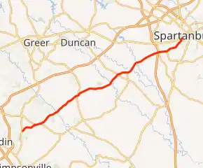
The west terminus of SC 296 is at a junction with SC 14 in west-central Greenville County and proceeds in a generally east-northeast direction. Shortly after the junction, the route merges with SC 146, but soon separates from SC 146 a short distance afterward. SC 296 then crosses into Spartanburg County as it traverses the Enoree River, and then intersects with SC 101 before passing through Reidville. Then, SC 296 intersects with SC 290 and SC 417 before intersecting with Interstate 26 (I-26) at exit 22 just outside the Spartanburg city limits. Within the city, SC 296 junctions with U.S. Route 29 (US 29) where the highway officially ends.[3]
Major intersections
| County | Location | mi[1][2] | km | Destinations | Notes |
|---|---|---|---|---|---|
| Greenville | Five Forks | 0.000 | 0.000 | Western terminus | |
| 1.740 | 2.800 | Western end of SC 146 concurrency | |||
| 2.440 | 3.927 | Eastern end of SC 146 concurrency | |||
| Spartanburg | Sugar Tit | 7.610 | 12.247 | ||
| Poplar Springs | 13.083 | 21.055 | |||
| | 14.273 | 22.970 | Eastern terminus of SC 417 | ||
| | 18.398 | 29.609 | I-26 exit 22 | ||
| Spartanburg | 18.543 | 29.842 | Western end of SC 295 concurrency; northern terminus of SC 215 | ||
| 19.443 | 31.290 | Eastern end of SC 295 concurrency | |||
| 21.803 | 35.089 | Eastern terminus | |||
1.000 mi = 1.609 km; 1.000 km = 0.621 mi
| |||||
See also
 U.S. roads portal
References
- "Highway Logmile Report". South Carolina Department of Transportation. Retrieved December 27, 2020.
- "Highway Logmile Report". South Carolina Department of Transportation. Retrieved December 27, 2020.
- Google (June 2, 2018). "South Carolina Highway 296" (Map). Google Maps. Google. Retrieved June 2, 2018.
External links
| Wikimedia Commons has media related to South Carolina Highway 296. |