Interstate 26 in South Carolina
Interstate 26 (I-26) is a South Carolina Interstate highway running generally east–west from near Landrum, in Spartanburg County, to U.S. Route 17, in Charleston, South Carolina. It is also the longest interstate highway in South Carolina.
| |
|---|---|
| James F. Brynes Memorial Freeway | |
 | |
| Route information | |
| Maintained by SCDOT | |
| Length | 220.7 mi[1] (355.2 km) |
| Existed | 1960–present |
| Major junctions | |
| West end | |
| East end | |
| Location | |
| Counties | Spartanburg, Laurens, Newberry, Lexington, Richland, Calhoun, Orangeburg, Dorchester, Berkeley, Charleston |
| Highway system | |
.svg.png.webp)
Route description
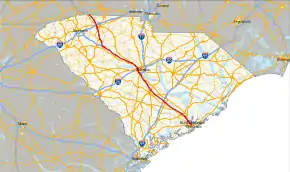
I-26 runs 220 miles through South Carolina. Mile markers run from west (north) to east (south). Mile Marker 0 is in the mountains at the NC state line. The last exit, at US 17 south of Charleston, is exit 221.
I-26 runs between the Broad and Saluda Rivers, descending from the mountains to the piedmont or midlands. At Columbia, I-126 crosses the confluence of the Broad and Saluda, which together form the Congaree, near the Columbia Canal and water treatment plant. I-26 continues following the Congaree, until it hops south over into the Cooper and Ashley Drainage, then down to the coast.
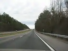
I-26 is predominantly a four-lane rural interstate with 70-mile-per-hour (110 km/h) speed limits. In the Columbia and Charleston areas, the interstate widens to six-lanes, but speeds are lower.
I-26 enters South Carolina just northeast of Landrum, traveling a southeasterly direction. The first major city along its route is Spartanburg, where it intersects I-85 to Greenville and Charlotte. As the interstate weaves along the terrain, it reaches Clinton; where westbound travelers can connect with I-385 towards Greenville. Traveling through the Sumter National Forest, it connects with Newberry before entering the Midlands. At Columbia in a section known as "Malfunction Junction", it connects with I-20, to Augusta and Florence, and I-126 towards the downtown area; it then goes south over the Saluda River and into Lexington County for the second of eventually four times along its course. At Cayce, it connects with I-77 to Charlotte. South of Cayce, the interstate goes up and down a few very long hills before reaching the outskirts of Orangeburg and I-95, to Savannah and Florence. As it enters the relatively flat plains of the Lowcountry, the area becomes urbanized as the interstate encroaches upon North Charleston and Charleston. As the interstate curves through the peninsula formed by the Ashley and Cooper rivers, it connects with I-526, to Savannah and Mount Pleasant. Near the end, it overlaps with US 17 from its new interchange (from the Arthur Ravenel Jr. Bridge) to where the old interchange remnants and where I-26 ends (formally where the John P. Grace Memorial Bridge and Silas N. Pearman Bridge connected).
Services
The South Carolina Department of Transportation (SCDOT) operates and maintains one welcome center and seven rest areas along I-26. Welcome centers, which have a travel information facility on site, are located at mile marker 3 (eastbound); rest areas are located at mile markers 63 (east and westbound), 123 (east and westbound), 150 (eastbound), 152 (westbound) and 204 (eastbound).[2] Common at all locations are public restrooms, public telephones, vending machines, picnic area and barbecue grills.[3]
The South Carolina Department of Public Safety (SCDPS) and State Transport Police (STP) operates and maintains three truck inspection/weigh stations. A westbound weigh station can be found at the 93.5 mile marker in Chapin 17 miles west of Columbia, and two others at mile marker 173 (eastbound) and mile marker 174 (westbound) in Harleyville east of the interchanges with Interstate 95 and US 15.[4][5]
History
Construction of I-26 began in 1957 in the Columbia area with the 9-mile (14 km) section from the Broad River to near Irmo.[6] The 11-mile (18 km) section of I-26 from I-126/US 76 in Columbia to US 176 at Exit 97 was the first section of the highway to open up to traffic (on September 7, 1960). The 6-mile (9.7 km) section from SC 210 to US 15 opened in September 1962.[7] Construction proceeded in stages heading both west up towards Greenville and east towards Charleston. The highway was largely completed from Columbia to North Charleston by 1964; the section from Aviation Avenue to the highway's terminus at US 17 in downtown Charleston progressed more slowly due to land takings for the right of way and numerous bridges and viaducts that had to be built. The entire 221 miles of I-26 were completed by February 1969.[6]
In the 1980s-90s, I-26 around Columbia was widened from four to six lanes. In the mid-90s, the North Charleston area was also widened from four to six lanes, part of which was further widened to eight lanes in the early 2010s. In 2005, the US 17 was realigned to a new interchange with I-26 at exit 220 from exit 221; the old interchange was mostly torn down and reconfigured, leaving the I-26 viaduct eastbound off-ramp and westbound on-ramps with US 17 south. In the mid-2010s, I-26 was widened SE of Columbia from I-77 to Old Sandy Run Rd. Starting in 2019 or 2020, a long stretch of I-26 NW of Columbia will begin widening construction from four to six lanes from SC 202 at Little Mountain to US 76/176 at Irmo.
In 2011, a plan to add a lane in each direction between Broad River Road and St. Andrews Road through "Malfunction Junction" had $8.5 million in funding but was expected to start sometime after 2012 and take two years.[8]
On October 5, 2016, I-26 had all lanes converted to westbound only, from I-77 to I-526, due to Hurricane Matthew.[9] This was done again on September 11, 2018 due to Hurricane Florence,[10] and in September 2019 for Hurricane Dorian.[11]
On November 19, 2016, construction began in Charleston to demolish, reconfigure and replace exits 217 and 218, related to a new access road to the Hugh K. Leatherman Sr. Terminal; construction and reopening planned for 2019.[12]
On October 18, 2018, SCDOT approved widening I-26 between Columbia, and Charleston. SCDOT plans to widen I-26 from Old Sandy Run Road in Calhoun County, to Ridgeville Road (SC 27) in Berkeley County.[13]
Auxiliary routes
| Interstate | City | Type | Notes | |
|---|---|---|---|---|
| Interstate 126 | Columbia | Spur | ||
| Interstate 326 | Columbia | Spur | Unsigned designation. Decommissioned. | |
| Interstate 526 | Charleston | Spur |
Exit list
| County | Location | mi[1] | km | Exit | Destinations | Notes | |
|---|---|---|---|---|---|---|---|
| Spartanburg | | 0.0 | 0.0 | Continuation into North Carolina | |||
| Landrum | 0.9 | 1.4 | 1 | ||||
| | 5.3 | 8.5 | 5 | ||||
| | 10.0 | 16.1 | 10 | ||||
| | 14.0 | 22.5 | 15 | ||||
| | 15.4 | 24.8 | 16 | John Dodd Road – Wellford | |||
| Southern Shops | 16.7 | 26.9 | 17 | New Cut Road | |||
| 17.8 | 28.6 | 18 | Signed as exits 18A (south) and 18B (north) | ||||
| 18.6 | 29.9 | 19 | Signed as exits 19A (south) and 19B (north) | ||||
| Spartanburg | 21.0 | 33.8 | 21 | Signed as exits 21A (south) and 21B (north); to Westgate Mall | |||
| 22.0 | 35.4 | 22 | |||||
| Moore | 28.1 | 45.2 | 28 | ||||
| | 34.5 | 55.5 | 35 | Walnut Grove Road – Woodruff | |||
| | 38.0 | 61.2 | 38 | ||||
| | 40.6 | 65.3 | 41 | ||||
| | 44.1 | 71.0 | 44 | ||||
| Laurens | Clinton | 51.8 | 83.4 | 51 | Westbound exit and eastbound entrance | ||
| 52.5 | 84.5 | 52 | |||||
| 53.6 | 86.3 | 54 | |||||
| | 59.7 | 96.1 | 60 | ||||
| Newberry | | 66.2 | 106.5 | 66 | Road 32 – Jalapa | ||
| | 71.5 | 115.1 | 72 | ||||
| Newberry | 74.0 | 119.1 | 74 | ||||
| 76.0 | 122.3 | 76 | |||||
| | 82.2 | 132.3 | 82 | ||||
| | 85.2 | 137.1 | 85 | ||||
| Lexington | Chapin | 91.2 | 146.8 | 91 | Columbia Avenue – Chapin | ||
| Richland | | 96.5 | 155.3 | 97 | |||
| Irmo | 101.4 | 163.2 | 101 | West end of US 76 overlap; signed as exits 101A (west) and 101B (east) | |||
| 102.2 | 164.5 | 102 | Signed as exits 102A (west) and 102B (east) | ||||
| Columbia | 103.4 | 166.4 | 103 | Harbison Boulevard | To Columbiana Centre | ||
| Lexington | Seven Oaks | 104.3 | 167.9 | 104 | Piney Grove Road | ||
| 106.4 | 171.2 | 106 | St. Andrews Road | ||||
| Richland | St. Andrews | 107.1 | 172.4 | 107 | Signed as exits 107A (west) and 107B (east) | ||
| Columbia | 107.6 | 173.2 | 108A | Bush River Road | |||
| 107.8 | 173.5 | 108B | East end of US 76 overlap | ||||
| Lexington | West Columbia | 109.7 | 176.5 | 110 | |||
| 111.3 | 179.1 | 111 | Signed as exits 111A (south) and 111B (north) | ||||
| Cayce | 113.2 | 182.2 | 113 | ||||
| 115.1 | 185.2 | 115 | |||||
| 115.6 | 186.0 | 116 | Southern terminus of I-77 | ||||
| | 119.5 | 192.3 | 119 | ||||
| Calhoun | | 124.6 | 200.5 | 125 | Old Sandy Run Road – Gaston | Closed during USMC Mud Run | |
| Lexington | | 128.7 | 207.1 | 129 | |||
| Calhoun | | 136.3 | 219.4 | 136 | |||
| | 139.3 | 224.2 | 139 | Burke Road – St. Matthews | |||
| Orangeburg | | 145.3 | 233.8 | 145 | Signed as exits 145A (south) and 145B (north) | ||
| | 148.5 | 239.0 | 149 | To SC State University and Claflin University | |||
| | 154.2 | 248.2 | 154 | Signed as exits 154A (south) and 154B (north) | |||
| | 159.0 | 255.9 | 159 | Homestead Road – Bowman | |||
| | 164.7 | 265.1 | 165 | ||||
| | 168.5 | 271.2 | 169 | Signed as exits 169A (south) and 169B (north) | |||
| Dorchester | | 171.5 | 276.0 | 172 | Signed as exits 172A (south) and 172B (north) | ||
| | 177.0 | 284.9 | 177 | ||||
| | 187.4 | 301.6 | 187 | ||||
| Berkeley | | 189 | Volvo Car Drive | To Volvo Cars manufacturing plant | |||
| | 194.4 | 312.9 | 194 | Road 16 – Jedburg, Pinopolis | |||
| Summerville | 197.5 | 317.8 | 197 | Nexton Parkway | Signed as exits 197A (south) and 197B (north) westbound | ||
| 199.0 | 320.3 | 199 | Signed as exits 199A (south) and 199B (north) | ||||
| Ladson | 203.2 | 327.0 | 203 | College Park Road – Ladson | |||
| Charleston | North Charleston | 205.0 | 329.9 | 205 | Signed as exits 205A (west) and 205B (east); to Charleston Southern University | ||
| Weber Boulevard | Proposed interchange (funded only for right of way procurement)[14] | ||||||
| 208.1 | 334.9 | 209A | Westbound exit and eastbound entrance; southern terminus of US 52 Conn. | ||||
| 208.6 | 335.7 | 209B | Ashley Phosphate Road | Signed as exit 209 eastbound; to Northwoods Mall | |||
| 211.1 | 339.7 | 211A | Aviation Avenue – Charleston AFB | ||||
| 211.6 | 340.5 | 211B | Remount Road – Hanahan | Formerly exit 211 before 2012; exits connected in both directions via collector-distributor lanes | |||
| 212.6 | 342.1 | 212 | Signed as exits 212B (west) and 212C (east) | ||||
| 213.5 | 343.6 | 213 | Montague Avenue / Tanger Outlet Boulevard / Mall Drive | Signed as exits 213A (Montague Avenue west, Tanger Outlet Boulevard) and 213B (Montague Avenue east) eastbound; eastbound exit only to Tanger Outlet Boulevard, westbound exit and entrance only to Mall Drive | |||
| 215.5 | 346.8 | 215 | |||||
| 216.3 | 348.1 | 216 | Signed as exits 216A (south) and 216B (north) | ||||
| Charleston | 217.5 | 350.0 | 217 | Closed November 19, 2016; to be reconfigured by 2019[12] | |||
| 218.0 | 350.8 | 218 | Spruill Avenue – Federal Complex | Closed November 19, 2016; to be reconfigured and become Port Access Road by 2019[12] | |||
| 219.0 | 352.4 | 219A | Rutledge Avenue – The Citadel | Eastbound exit and westbound entrance | |||
| 219.3 | 352.9 | 219B | Morrison Drive, East Bay Street (US 52 Spur) | Eastbound exit and westbound entrance | |||
| 220.2 | 354.4 | 220A | Romney Street | Westbound exit only | |||
| 220.3 | 354.5 | 220B | North end of US 17 overlap; signed as exit 220 eastbound | ||||
| 220.4 | 354.7 | 221A | South end of US 17 overlap; eastbound exit and westbound entrance | ||||
| 220.4 | 354.7 | 221B | Eastbound exit and westbound entrance I-26 officially ends .3 miles (0.48 km) at the remnants of old exit 221 | ||||
| East end of I-26 | |||||||
1.000 mi = 1.609 km; 1.000 km = 0.621 mi
| |||||||
References
- Google (July 4, 2013). "Interstate 26 in South Carolina" (Map). Google Maps. Google. Retrieved July 4, 2013.
- South Carolina Interstate 26 (Interstate Rest Areas)
- "SC Rest Areas Map". South Carolina Department of Transportation. Retrieved December 29, 2014.
- South Carolina Weigh Station & DOT Information (Coops are Open)
- Distance between Exits 172 A-B (US 15) and eastbound Truck Weigh Station (Google Maps)
- "Economic Development History of Interstate 26 in South Carolina". Federal Highway Administration. Retrieved 7 March 2013.
- "Another Stretch of I-26 is Open". The News and Courier. 24 September 1962. Retrieved 7 March 2013.
- Littlefield, Susan-Elizabeth (2011). "DOT looking for suggestions to fix 'malfunction junction'". Columbia, SC: WIS. Retrieved July 13, 2016.
- Behre, Robert (October 3, 2016). "Get out of town: I-26 lane reversal may get real test Epic traffic snarl during Hurricane Floyd led to change". The Post and Courier. Retrieved October 5, 2016.
- Jackson, Angie (September 10, 2018). "I-26 east to close from Columbia to Charleston early Tuesday to set up for lane reversal". The Post and Courier. Retrieved September 11, 2018.
- Daprile, Lucas (2019-09-04). "McMaster will keep I-26 lanes reversed for an additional two hours". The State.
- "I-26 exit ramps to close for new port access project to begin". Charleston, SC: WCBD-TV. November 18, 2016. Retrieved March 27, 2017.
- "At last, I-26 widening is a priority". The Times and Democrat. October 28, 2018.
- Knich, Diane; McDermott, John (May 30, 2013). "Airport road projects to take off County Council vote begins process for new I-26 interchange, other improvements". The Post and Courier. Retrieved May 31, 2013.
External links
 Media related to Interstate 26 in South Carolina at Wikimedia Commons
- Mapmikey's South Carolina Highways Page: I-26
- Economic Development History of Interstate 26 in South Carolina - Federal Highway Administration
| Previous state: North Carolina |
South Carolina | Next state: Terminus |
1Former | ||