South Carolina Highway 381
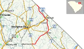
South Carolina Highway 381 (SC 381) is a 22.700-mile (36.532 km) primary state highway in the U.S. state of South Carolina. It connects the towns in eastern Marlboro County.
| ||||
|---|---|---|---|---|
 | ||||
| Route information | ||||
| Maintained by SCDOT | ||||
| Length | 22.700 mi[1] (36.532 km) | |||
| Existed | 1930–present | |||
| Major junctions | ||||
| South end | ||||
| North end | ||||
| Location | ||||
| Counties | Marlboro | |||
| Highway system | ||||
| ||||
Route description
SC 381 traverses from Blenheim at SC 38 to the North Carolina state line where it continues as North Carolina Highway 381 into Gibson, North Carolina. As a two-lane rural highway, it connects the towns of Clio and McColl.[2]
History
The highway was established in 1930 as a new primary route from SC 38 in Blenheim to SC 9 in Clio. In 1931 or 1932, it was extended north to SC 30 (today U.S. Route 15 (US 15) and US 401) in McColl; and west to the community of Marlboro. In 1934, the western extension was dropped while it extended north again to the North Carolina state line. In 1940, SC 381 was extended west again to SC 382 in Scott, only to be truncated back in Blenheim by 1948.[3]
Major intersections
The entire route is in Marlboro County.
| Location | mi[1] | km | Destinations | Notes | |
|---|---|---|---|---|---|
| Blenheim | 0.000 | 0.000 | Southern terminus | ||
| | Proposed interchange[4][5] | ||||
| Clio | 8.390 | 13.502 | |||
| | 9.850 | 15.852 | Southern terminus of SC 83 | ||
| McColl | 15.630 | 25.154 | |||
| | 22.700 | 36.532 | Continuation into North Carolina | ||
1.000 mi = 1.609 km; 1.000 km = 0.621 mi
| |||||
See also
 U.S. roads portal
References
- "Highway Logmile Report". South Carolina Department of Transportation. Retrieved December 28, 2020.
- Google (September 3, 2012). "South Carolina Highway 381" (Map). Google Maps. Google. Retrieved September 3, 2012.
- "Mapmikey's South Carolina Highways Page". Retrieved September 3, 2012.
- "Project Status: Northern Project". I-73 Environmental Impact Study. South Carolina Department of Transportation. Retrieved September 4, 2012.
- I-73 Northern Map (PDF) (Map). South Carolina Department of Transportation. Blenheim inset. Retrieved September 4, 2012.
External links
 Media related to South Carolina Highway 381 at Wikimedia Commons
- SC 381 at Virginia Highways' South Carolina Highways Annex
