Interstate 385
Interstate 385 (I-385) is an Interstate Highway located in the Upstate region of South Carolina. I-385 is a spur route of Interstate 85. The highway provides a connection between Greenville and Columbia.
| ||||
|---|---|---|---|---|
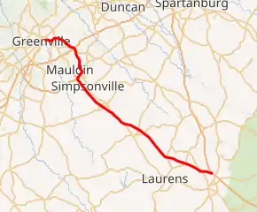
I-385 highlighted in red | ||||
| Route information | ||||
| Auxiliary route of I-85 | ||||
| Maintained by SCDOT | ||||
| Length | 42.16 mi[1] (67.85 km) | |||
| Existed | 1962–present | |||
| Major junctions | ||||
| South end | ||||
| ||||
| North end | ||||
| Location | ||||
| Counties | Laurens, Greenville | |||
| Highway system | ||||
| ||||
.svg.png.webp)
Route description
After exit 42, Interstate 385 turns into a Business Spur and becomes East North Street and later — for northbound motorists only — Beattie Place. The spur promptly ends at US 29 (Church Street) near the Bon Secours Wellness Arena in downtown Greenville.
The explosive economic growth of southern Greenville county is largely attributed to I-385 and its connection to the city of Greenville and the major cities of Atlanta and Charlotte (via I-85). This area is known by locals as the "Golden Strip".
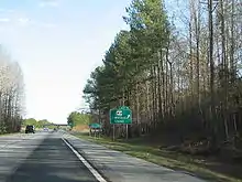
I-385 features a rather unusual rest area in the median strip near Laurens, that serves both directions of traffic. It was completed as part of the original design of the U.S. 276 expressway in 1958, modeled after the type of single median-located rest areas shared by both north and southbound traffic (to save money). The design is similar to many of those built on turnpikes that predated the Interstate System.
History
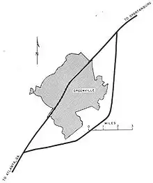
The general idea — but none of the specifics — of I-385 were present on the 1955 Yellow Book map of the Greenville area. Also of note is that Interstate 85 would have used the US 29 corridor from Greenville east towards Spartanburg based on the diagram.
The portion of I-385 that replaced US 276[2] (from SC 417 in Mauldin to SC 56/I-26 in Clinton) was initially the first phase built of an SC DOT plan that predated the Interstate System to upgrade and bypass existing through routes, the goal of forming a single limited-access highway from Greenville to the port of Charleston via the State Capital of Columbia. This plan was scrapped as soon as the future I-26 was added to the act of Congress that set into motion the Interstate System. As a result, I-26 was one of the first Interstates in the south to open in significant mileage (most in SC between 1959 and 1963).
Prior to 1985, I-385 was only signed as such from downtown Greenville to I-85. The portion of the freeway from US 276 in Mauldin to the southern terminus at I-26 was signed as US 276. When the connecting portion was completed, the entire freeway was signed as I-385.
For seven months ending July 23, 2010, northbound traffic could not use a 15-mile section of I-385 in Laurens County due to a $60.9 million project to pave the portion extending from South Carolina Highway 101 to the I-385-I-26 interchange near Clinton, SC in concrete. The closing of a major highway generated controversy.[3] Closing the interstate for construction saved approximately $34 million.[2]
Between 2002 and 2012, I-385 was widened from 2 to 3 lanes in each direction from just north of exit 24 near Fountain Inn to just south of Woodruff Rd/SC 146 (exit 35), with the portion between exits 31 and 35 resurfaced in concrete.[4]
Beginning in February 2016 and expected to continue through 2020, the I-385/I-85 interchange is being reconstructed to decrease congestion and related accidents.[5]
Exit list
| County | Location | mi | km | Exit | Destinations | Notes |
|---|---|---|---|---|---|---|
| Laurens | Clinton | 0.00 | 0.00 | — | Southern terminus | |
| 2.00 | 3.22 | 2 | ||||
| Laurens | 5.31 | 8.55 | 5 | |||
| 8.55 | 13.76 | 9 | ||||
| Gray Court | 10.34 | 16.64 | 10 | Metric Road – Gray Court | ||
| 15.87 | 25.54 | 16 | ||||
| 18.87 | 30.37 | 19 | Southern end of SC 14 concurrency | |||
| Fountain Inn | 21.63 | 34.81 | 22 | Northern end of SC 14 concurrency | ||
| Greenville | 23.10 | 37.18 | 23 | |||
| 24.11 | 38.80 | 24 | Fairview Street – Fountain Inn | |||
| Simpsonville | 25.77 | 41.47 | 26 | Harrison Bridge Road | ||
| 27.13 | 43.66 | 27 | Fairview Road – Simpsonville | |||
| 28.71 | 46.20 | 29 | Georgia Road – Simpsonville | |||
| Mauldin | 30.14 | 48.51 | 30 | Southern terminus of I-185/US 276 | ||
| 30.98 | 49.86 | 31 | No southbound exit; southbound exit is via exit 30. | |||
| 33.07 | 53.22 | 33 | Bridges Road – Mauldin | |||
| 34.13 | 54.93 | 34 | Butler Road – Mauldin | |||
| 35.50 | 57.13 | 35 | ||||
| Greenville | 36.20 | 58.26 | 36 | Signed as exits 36A (north) and 36B (south) northbound; single exit 36 southbound; I-85 exits 51B-C | ||
| 37.29 | 60.01 | 37 | Roper Mountain Road | |||
| 38.87 | 62.56 | 39 | Haywood Road | |||
| 40.11 | 64.55 | 40 | ||||
| 41.86 | 67.37 | 42 | ||||
| 42.16 | 67.85 | — | East North Street (I-385 Bus. north) | Continuation as unsigned I-385 Bus. | ||
1.000 mi = 1.609 km; 1.000 km = 0.621 mi
| ||||||
Interstate 385 Business
| |
|---|---|
| Location | Greenville, South Carolina |
| Length | 0.490 mi[6] (0.789 km) |
| Existed | 1962–present |
Interstate 385 Business (I-385 Bus.) is a 0.490-mile (0.789 km) boulevard-grade business route of I-385 along North Street, between Stone Avenue (US 276) and Church Street (US 29). It is an unsigned highway. Its continuation along North Street becomes SC 183. It also connects to US 123 (Academy Street) and SC 183 (Beattie Place).[7] Signage previously existed for this spur route, but by 2007 has been removed; appears only in the SCDOT Greenville–Spartanburg Metro map.[8]
See also
 U.S. roads portal
References
- "Route Log - Auxiliary Routes of the Eisenhower National System Of Interstate and Defense Highways - Table 2". Federal Highway Administration. Retrieved October 5, 2014.
- American Association of State Highway and Transportation Officials (May 2012). "AASHTO Project Profiles: South Carolina Department of Transportation I-385 Rehabilitation Project". Archived from the original on March 3, 2016. Retrieved May 15, 2012.
- Cay, Nathaniel (July 25, 2010). "I-385 reopened after 7-month closure". Greenville News. Retrieved July 25, 2010.
- "I-385 widening". South Carolina Department of Transportation. September 9, 2012. Retrieved January 8, 2013.
- "I-85/385 Gateway". www.85385gateway.com.
- "Highway Logmile Report". South Carolina Department of Transportation. Retrieved December 14, 2020.
- Google (May 19, 2013). "Overview map of I-385 Bus. (Greenville)" (Map). Google Maps. Google. Retrieved May 19, 2013.
- Greenville–Spartanburg Urban Area (PDF) (Map). South Carolina Department of Transportation. September 2013. p. Sheet 16. § G5. Retrieved December 14, 2020.
External links
 Media related to Interstate 385 at Wikimedia Commons
- Mapmikey's South Carolina Highways Page: I-385