South Dakota Highway 153
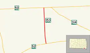
South Dakota Highway 153 (SD 153), also known as 435th Avenue, is a state highway in Yankton County, South Dakota, United States, that runs from South Dakota Highway 52 (SD 52) to South Dakota Highway 50 (SD 50). 494 metres (1,621 ft)
| ||||
|---|---|---|---|---|
| 435th Avenue | ||||
 | ||||
| Route information | ||||
| Defined by SDCL §31-4-199 | ||||
| Maintained by SDDOT | ||||
| Length | 2.369 mi[1] (3.813 km) | |||
| Major junctions | ||||
| South end | ||||
| North end | ||||
| Location | ||||
| Counties | Yankton | |||
| Highway system | ||||
| ||||

Route description
SD 153 begins at an intersection with SD 52 on the north edge of the Lewis & Clark Recreation Area, west of the city of Yankton. (SD 52 heads east to Yankton and heads westerly before curving north and then west to run concurrent with SR 50 through Lakeport. The road continues south for a short distance as Shore Drive to the marina of the recreation area.) From its southern terminus SD 153 heads north (but slightly west) along 435th Avenue through a rural residential area. The route then bends slightly to head directly north through rolling farmland until it reaches its northern terminus at SD 50. (435th Avenue continues north as County Road 211 through Utica and beyond to end at South Dakota Highway 49. SD 50 heads east to quickly connect with the northern end of South Dakota Highway 314 and then on through Yankton and beyond. SD 50 heads west to run concurrent with SD 52 through Lakeport.)[2][3]
SD 153 is maintained by South Dakota Department of Transportation (SDDOT). In 2012, the traffic on the highway was measured in average annual daily traffic, and SD 153 had an average of 610 vehicles.[1] The route is not a part of the National Highway System,[4] a system of highways important to the nation's defense, economy, and mobility.[5]
Major intersections
The entire route is in Yankton County.
| Location | mi[1] | km | Destinations | Notes | |
|---|---|---|---|---|---|
| Lewis & Clark Recreation Area | 0.000 | 0.000 | Southern terminus | ||
| | 2.369 | 3.813 | Northern terminus | ||
| 1.000 mi = 1.609 km; 1.000 km = 0.621 mi | |||||
References
- "State Highway Log" (PDF). South Dakota Department of Transportation. January 2012. Retrieved March 3, 2013.
- Google (March 3, 2013). "South Dakota Highway 153" (Map). Google Maps. Google. Retrieved March 3, 2013.
- South Dakota Atlas & Gazetteer. Yarmouth, ME: DeLorme. 2009. p. 69. ISBN 0-89933-330-3.
- National Highway System: South Dakota (PDF) (Map). Federal Highway Administration. October 1, 2012. Retrieved March 3, 2013.
- Natzke, Stefan; Neathery, Mike; Adderly, Kevin (September 26, 2012). "What is the National Highway System?". National Highway System. Federal Highway Administration. Retrieved March 3, 2013.
External links
| Wikimedia Commons has media related to South Dakota Highway 153. |