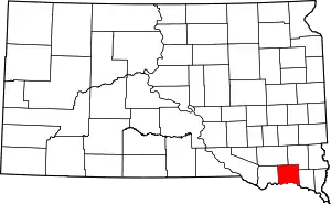
Yankton County, South Dakota
Yankton County is a county in the U.S. state of South Dakota. As of the 2010 United States Census, the population was 22,438.[1] Its county seat is Yankton.[2] Yankton County comprises the Yankton, SD Micropolitan Statistical Area.
Yankton County | |
|---|---|
_from_E_1.JPG.webp) Scottish Rite Masonic Center in Yankton. | |
 Location within the U.S. state of South Dakota | |
 South Dakota's location within the U.S. | |
| Coordinates: 43°01′N 97°23′W | |
| Country | |
| State | |
| Founded | April 10, 1862 |
| Named for | Yankton Sioux |
| Seat | Yankton |
| Largest city | Yankton |
| Area | |
| • Total | 532 sq mi (1,380 km2) |
| • Land | 521 sq mi (1,350 km2) |
| • Water | 11 sq mi (30 km2) 2.1% |
| Population (2010) | |
| • Total | 22,438 |
| • Estimate (2018) | 22,869 |
| • Density | 42/sq mi (16/km2) |
| Time zone | UTC−6 (Central) |
| • Summer (DST) | UTC−5 (CDT) |
| Congressional district | At-large |
| Website | www |
Geography
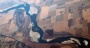
Yankton County lies on the south side of South Dakota. Its south boundary line abuts the north boundary line of the state of Nebraska (across the Missouri River). The Missouri flows eastward along the county's south border. The James River flows south-southeastward through the west central portion of the county, discharging into the Missouri near the midpoint of the county's south line. The county terrain consists of rolling hills, carved by creeks and drainages, hosting several lakes and ponds. The area is devoted to agriculture.[3] The terrain slopes to the south and the east. Its highest point is 1,473' (449m) ASL, on the eastern portion of its north boundary line.[4] The county has a total area of 532 square miles (1,380 km2), of which 521 square miles (1,350 km2) is land and 11 square miles (28 km2) (2.1%) is water.[5]
Lewis & Clark Lake, a popular regional tourist and recreational destination is found in the southwestern part of the county.[6]
Major highways
Airports
Adjacent counties
- Turner County - northeast
- Clay County - east
- Cedar County, Nebraska - southeast
- Knox County, Nebraska - southwest
- Bon Homme County - west
- Hutchinson County - northwest
Protected areas[3]
- Chief White Crane Recreation Area
- Dakota Territorial Capitol Building/Riverside Park
- Diede Waterfowl Production Area
- Edelman Waterfowl Production Area
- Gavins Point National Fish Hatchery & Aquarium
- Hansen Waterfowl Production Area
- Lewis & Clark Recreation Area
- Missouri National Recreational River (part)
- Pierson Ranch Recreation Area
- Lake Yankton Island Wildlife Area
Lakes and Reservoirs
- Beaver Lake
- Guthmiller Lake
- Lake Yankton
- Lewis and Clark Lake (part)
- Marindahl Lake
Demographics
| Historical population | |||
|---|---|---|---|
| Census | Pop. | %± | |
| 1870 | 2,097 | — | |
| 1880 | 8,390 | 300.1% | |
| 1890 | 10,414 | 24.1% | |
| 1900 | 12,649 | 21.5% | |
| 1910 | 13,135 | 3.8% | |
| 1920 | 15,233 | 16.0% | |
| 1930 | 16,589 | 8.9% | |
| 1940 | 16,725 | 0.8% | |
| 1950 | 16,804 | 0.5% | |
| 1960 | 17,551 | 4.4% | |
| 1970 | 19,039 | 8.5% | |
| 1980 | 18,952 | −0.5% | |
| 1990 | 19,252 | 1.6% | |
| 2000 | 21,652 | 12.5% | |
| 2010 | 22,438 | 3.6% | |
| 2019 (est.) | 22,814 | [7] | 1.7% |
| US Decennial Census[8] 1790-1960[9] 1900-1990[10] 1990-2000[11] 2010-2018[1] | |||
2000 census
As of the 2000 United States Census,[12] there were 21,652 people, 8,187 households, and 5,403 families in the county. The population density was 42 people per square mile (16/km2). There were 8,840 housing units at an average density of 17 per square mile (7/km2). The racial makeup of the county is 95.10% White, 1.16% African American, 1.63% Native American, 0.42% Asian, 0.02% Pacific Islander, 0.74% from other races, and 0.91% from two or more races. 1.82% of the population are Hispanic or Latino of any race.
There were 8,187 households, out of which 33.00% had children under the age of 18 living with them, 54.40% were married couples living together, 8.30% had a female householder with no husband present, and 34.00% were non-families. 29.30% of all households were made up of individuals, and 12.00% had someone living alone who was 65 years of age or older. The average household size was 2.43 and the average family size was 3.03.
The county population contained 25.70% under the age of 18, 8.70% from 18 to 24, 29.00% from 25 to 44, 22.00% from 45 to 64, and 14.60% who were 65 years of age or older. The median age was 37 years. For every 100 females there were 101.90 males. For every 100 females age 18 and over, there were 101.30 males.
The median income for a household in the county was $35,374, and the median income for a family was $43,600. Males had a median income of $29,010 versus $20,686 for females. The per capita income for the county was $17,312. About 6.60% of families and 9.60% of the population were below the poverty line, including 10.00% of those under age 18 and 9.00% of those age 65 or over.
2010 census
As of the 2010 United States Census, there were 22,438 people, 8,770 households, and 5,476 families in the county.[13] The population density was 43.1 inhabitants per square mile (16.6/km2). There were 9,652 housing units at an average density of 18.5 per square mile (7.1/km2).[14] The racial makeup of the county was 92.8% white, 2.5% American Indian, 1.5% black or African American, 0.5% Asian, 1.1% from other races, and 1.4% from two or more races. Those of Hispanic or Latino origin made up 2.7% of the population.[13] In terms of ancestry,[15]
Of the 8,770 households, 29.2% had children under the age of 18 living with them, 50.1% were married couples living together, 8.8% had a female householder with no husband present, 37.6% were non-families, and 32.0% of all households were made up of individuals. The average household size was 2.30 and the average family size was 2.90. The median age was 41.3 years.[13]
The median income for a household in the county was $47,124 and the median income for a family was $62,070. Males had a median income of $37,637 versus $29,488 for females. The per capita income for the county was $24,776. About 5.0% of families and 11.2% of the population were below the poverty line, including 10.7% of those under age 18 and 13.5% of those age 65 or over.[16]
Communities
Townships
- Gayville
- Jamesville
- Marindahl
- Mayfield
- Mission Hill
- Turkey Valley
- Utica
- Volin
- Walshtown
Unorganized territories
- Southeast Yankton
- West Yankton
Politics and government
Yankton County is Governed by the County Commission, a five-member legislative body elected at-large.[17] The current commissioners are:
- Dan Klimisch, Chairman
- Cheri Loest, Vice Chairman
- Don Kettering
- Joe Healy
- Gary Swensen
The county is located in South Dakota Legislative District 18. As of 2019, Yankton County is represented in the South Dakota Senate by Senator Craig Kennedy-(D), and in the South Dakota House of Representatives by State Representatives Jean Hunhoff-(R) and Ryan Cwach-(D).[18] The county is located in South Dakota's At-Large Congressional District, currently held by Republican Dusty Johnson.
In national elections, Yankton County voters have been reliably Republican for several decades. In no national election since 1964 has the county selected the Democratic Party candidate.
| Year | Republican | Democratic | Third parties |
|---|---|---|---|
| 2020 | 60.4% 6,581 | 36.8% 4,016 | 2.8% 303 |
| 2016 | 58.8% 5,659 | 34.3% 3,301 | 6.9% 663 |
| 2012 | 55.1% 5,495 | 42.4% 4,226 | 2.5% 253 |
| 2008 | 49.7% 5,039 | 47.7% 4,838 | 2.5% 257 |
| 2004 | 57.6% 6,003 | 40.6% 4,237 | 1.8% 191 |
| 2000 | 56.1% 4,904 | 41.1% 3,596 | 2.8% 240 |
| 1996 | 44.0% 3,885 | 42.8% 3,775 | 13.2% 1,166 |
| 1992 | 36.6% 3,430 | 36.3% 3,404 | 27.1% 2,538 |
| 1988 | 52.1% 4,186 | 47.0% 3,777 | 1.0% 80 |
| 1984 | 63.4% 5,161 | 36.0% 2,932 | 0.6% 52 |
| 1980 | 61.2% 5,355 | 30.8% 2,698 | 7.9% 694 |
| 1976 | 49.8% 4,029 | 49.3% 3,987 | 0.9% 71 |
| 1972 | 53.1% 4,366 | 46.6% 3,835 | 0.3% 24 |
| 1968 | 56.1% 3,977 | 38.5% 2,733 | 5.4% 382 |
| 1964 | 46.1% 3,208 | 53.9% 3,747 | |
| 1960 | 57.0% 4,065 | 43.0% 3,061 | |
| 1956 | 57.6% 4,063 | 42.4% 2,987 | |
| 1952 | 68.4% 4,802 | 31.6% 2,220 | |
| 1948 | 49.3% 2,904 | 49.8% 2,932 | 1.0% 57 |
| 1944 | 58.4% 3,313 | 41.6% 2,359 | |
| 1940 | 57.7% 4,179 | 42.3% 3,064 | |
| 1936 | 36.3% 2,702 | 58.5% 4,349 | 5.2% 387 |
| 1932 | 25.2% 1,693 | 73.3% 4,930 | 1.6% 107 |
| 1928 | 50.9% 2,971 | 48.7% 2,841 | 0.5% 27 |
| 1924 | 39.8% 1,504 | 18.3% 693 | 41.9% 1,584 |
| 1920 | 61.8% 2,555 | 27.8% 1,147 | 10.5% 432 |
| 1916 | 48.7% 1,429 | 49.0% 1,438 | 2.4% 70 |
| 1912 | 0.0% 0 | 44.0% 1,289 | 56.0% 1,639 |
| 1908 | 56.8% 1,644 | 38.6% 1,118 | 4.6% 132 |
| 1904 | 69.0% 1,968 | 27.6% 788 | 3.3% 95 |
| 1900 | 55.8% 1,639 | 43.1% 1,268 | 1.1% 33 |
| 1896 | 51.4% 1,423 | 48.0% 1,330 | 0.6% 16 |
| 1892 | 54.0% 1,166 | 10.6% 228 | 35.5% 766 |
Recreation and Tourism
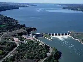
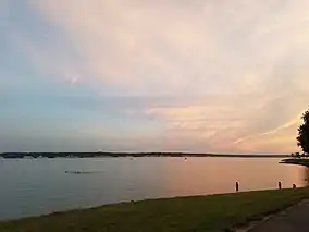
Lewis and Clark Lake is located in southwestern Yankton County, four miles (6 km) west of Yankton. The Lewis & Clark Lake area is a popular regional tourist and recreation destination with parks, trails, campgrounds, boat ramps, and marinas. Gavins Point Dam, which creates Lewis & Clark Lake, is a popular fishing destination on the Missouri River.[20] The South Dakota Department of Game, Fish, and Parks operates the Lewis & Clark State Recreation Area on the northern shore of the lake.
Below Gavins Point Dam, the Missouri National Recreational River is home to one of the few non-channelized portions of the "Big Muddy", and is popular with birdwatchers, hunters, canoers, and kayakers.[21]
References
- "State & County QuickFacts". United States Census Bureau. Retrieved November 28, 2013.
- "Find a County". National Association of Counties. Retrieved June 7, 2011.
- Yankton County SD Google Maps (accessed 9 February 2019)
- ""Find an Altitude" Google Maps (accessed February 9, 2019)". Archived from the original on May 21, 2019. Retrieved February 10, 2019.
- "2010 Census Gazetteer Files". US Census Bureau. August 22, 2012. Retrieved March 28, 2015.
- Missouri River Dams
- "Annual Estimates of the Resident Population for Counties: April 1, 2010 to July 1, 2019". Retrieved April 10, 2020.
- "US Decennial Census". US Census Bureau. Retrieved March 28, 2015.
- "Historical Census Browser". University of Virginia Library. Retrieved March 28, 2015.
- Forstall, Richard L., ed. (March 27, 1995). "Population of Counties by Decennial Census: 1900 to 1990". US Census Bureau. Retrieved March 28, 2015.
- "Census 2000 PHC-T-4. Ranking Tables for Counties: 1990 and 2000" (PDF). US Census Bureau. April 2, 2001. Retrieved March 28, 2015.
- "U.S. Census website". US Census Bureau. Retrieved May 14, 2011.
- "Profile of General Population and Housing Characteristics: 2010 Demographic Profile Data". US Census Bureau. Archived from the original on February 13, 2020. Retrieved March 12, 2016.
- "Population, Housing Units, Area, and Density: 2010 - County". US Census Bureau]]. Archived from the original on February 13, 2020. Retrieved March 12, 2016.
- "Selected Social Characteristics in the US – 2006-2010 American Community Survey 5-Year Estimates". US Census Bureau. Archived from the original on February 13, 2020. Retrieved March 12, 2016.
- "Selected Economic Characteristics – 2006-2010 American Community Survey 5-Year Estimates". US Census Bureau. Archived from the original on February 13, 2020. Retrieved March 12, 2016.
- Yankton County Commission
- SD Legislature
- Leip, David. "Atlas of US Presidential Elections". uselectionatlas.org. Retrieved April 15, 2018.
- "Omaha District > Missions > Dam and Lake Projects > Missouri River Dams > Gavins Point". www.nwo.usace.army.mil. Retrieved April 15, 2018.
- National Park Service/MNRR
External links
| Wikimedia Commons has media related to Yankton County, South Dakota. |
- Yankton County (Official website)
- U.S. Census Data - Yankton County
- . The American Cyclopædia. 1879.
Places adjacent to Yankton County, South Dakota | ||||||||||
|---|---|---|---|---|---|---|---|---|---|---|
| ||||||||||
Municipalities and communities of Yankton County, South Dakota, United States | ||
|---|---|---|
| Cities | | |
| Towns | ||
| Footnotes | ‡This populated place also has portions in an adjacent county or counties | |
| ||

| Authority control |
|---|