South Dakota Highway 71
South Dakota Highway 71 (SD 71) is a 35.59-mile (57.28 km) state highway in Fall River County, South Dakota, United States, that travels from the Nebraska state line (where it continues as N-2/N-71 through the Black Hills National Forest) to U.S. Route 18 Bypass (US 18 Byp.) in Hot Springs.
| ||||
|---|---|---|---|---|
| Cascade Road | ||||
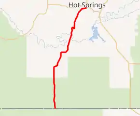
SD highlighted in red | ||||
| Route information | ||||
| Defined by SDCL §31-4-175 | ||||
| Maintained by SDDOT | ||||
| Length | 35.59 mi[1] (57.28 km) | |||
| Existed | 1962–present | |||
| Major junctions | ||||
| South end | ||||
| North end | ||||
| Location | ||||
| Counties | Fall River | |||
| Highway system | ||||
| ||||

Route description
SD 71's southern terminus is at the Nebraska border in Black Hills National Forest where it has the same number.[2]
In the forest, the route meets the terminus of South Dakota Highway 471. After that, it leaves the forest and ends at US 18 Byp. in Hot Springs.[3]
History
The road was originally commissioned in 1936 as part of South Dakota Highway 87. Part of that highway was given the SD 71 designation in 1962.
Major intersections
The entire route is in Fall River County.
| Location | mi[1] | km | Destinations | Notes | |
|---|---|---|---|---|---|
| Unorganized Territory of Southwest Fall River | 0.00 | 0.00 | Continuation beyond Nebraska state line | ||
| | 28.53 | 45.91 | Southern terminus of SD 471 | ||
| Hot Springs | 35.59 | 57.28 | Northern terminus of SD 71 | ||
| 1.000 mi = 1.609 km; 1.000 km = 0.621 mi | |||||
References
- Staff. "State Highway Log: Rapid City Region" (PDF). South Dakota Department of Transportation. Retrieved February 4, 2014.
- Google (February 5, 2014). "Hot Springs, South Dakota" (Map). Google Maps. Google. Retrieved February 5, 2014.
- Google (February 5, 2014). "Nebraska–South Dakota State Line" (Map). Google Maps. Google. Retrieved February 5, 2014.
External links
![]() Media related to South Dakota Highway 71 at Wikimedia Commons
Media related to South Dakota Highway 71 at Wikimedia Commons