South Hutchinson, Kansas
South Hutchinson is a city in Reno County, Kansas, United States, and a suburb of Hutchinson. As of the 2010 census, the city population was 2,457.[9]
South Hutchinson, Kansas | |
|---|---|
 Seal | |
 Location within Reno County and Kansas | |
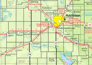 KDOT map of Reno County (legend) | |
| Coordinates: 38°1′38″N 97°56′23″W | |
| Country | United States |
| State | Kansas |
| County | Reno |
| Founded | 1887 |
| Incorporated | 1887 |
| Named for | South of Hutchinson |
| Government | |
| • Mayor | Dave Pitman [1][2] |
| Area | |
| • Total | 2.88 sq mi (7.47 km2) |
| • Land | 2.84 sq mi (7.36 km2) |
| • Water | 0.04 sq mi (0.11 km2) |
| Elevation | 1,529 ft (466 m) |
| Population | |
| • Total | 2,457 |
| • Estimate (2019)[5] | 2,488 |
| • Density | 875.13/sq mi (337.92/km2) |
| Time zone | UTC-6 (CST) |
| • Summer (DST) | UTC-5 (CDT) |
| ZIP code | 67505 [6] |
| Area code | 620 |
| FIPS code | 20-66750 [7] |
| GNIS ID | 0477972 [8] |
| Website | southhutch.com |
History
The city was founded in 1887 by Benjamin Blanchard of Terre Haute, Indiana.
The first post office in South Hutchinson was established in August 1887.[10]
Geography
South Hutchinson is located at 38°1′38″N 97°56′23″W (38.027185, -97.939769).[11] According to the United States Census Bureau, the city has a total area of 2.89 square miles (7.49 km2), of which 2.87 square miles (7.43 km2) is land and 0.02 square miles (0.05 km2) is water.[12]
Demographics
| Historical population | |||
|---|---|---|---|
| Census | Pop. | %± | |
| 1890 | 321 | — | |
| 1900 | 225 | −29.9% | |
| 1910 | 387 | 72.0% | |
| 1920 | 639 | 65.1% | |
| 1930 | 669 | 4.7% | |
| 1940 | 915 | 36.8% | |
| 1950 | 1,045 | 14.2% | |
| 1960 | 1,672 | 60.0% | |
| 1970 | 1,879 | 12.4% | |
| 1980 | 2,226 | 18.5% | |
| 1990 | 2,444 | 9.8% | |
| 2000 | 2,539 | 3.9% | |
| 2010 | 2,457 | −3.2% | |
| 2019 (est.) | 2,488 | [5] | 1.3% |
| U.S. Decennial Census | |||
2010 census
As of the census[4] of 2010, there were 2,457 people, 1,113 households, and 611 families residing in the city. The population density was 856.1 inhabitants per square mile (330.5/km2). There were 1,207 housing units at an average density of 420.6 per square mile (162.4/km2). The racial makeup of the city was 91.9% White, 1.1% African American, 1.0% Native American, 0.6% Asian, 0.1% Pacific Islander, 2.3% from other races, and 3.1% from two or more races. Hispanic or Latino of any race were 6.6% of the population.
There were 1,113 households, of which 24.4% had children under the age of 18 living with them, 39.6% were married couples living together, 10.9% had a female householder with no husband present, 4.4% had a male householder with no wife present, and 45.1% were non-families. 40.3% of all households were made up of individuals, and 19% had someone living alone who was 65 years of age or older. The average household size was 2.08 and the average family size was 2.80.
The median age in the city was 47.7 years. 21.4% of residents were under the age of 18; 6.9% were between the ages of 18 and 24; 18.5% were from 25 to 44; 26.8% were from 45 to 64; and 26.5% were 65 years of age or older. The gender makeup of the city was 45.6% male and 54.4% female.
2000 census
As of the census[7] of 2000, there were 2,539 people, 1,143 households, and 675 families residing in the city. The population density was 912.4 people per square mile (352.6/km2). There were 1,210 housing units at an average density of 434.8 per square mile (168.1/km2). The racial makeup of the city was 93.46% White, 0.79% African American, 0.59% Native American, 0.24% Asian, 0.04% Pacific Islander, 3.23% from other races, and 1.65% from two or more races. Hispanic or Latino of any race were 5.32% of the population.
There were 1,143 households, out of which 24.8% had children under the age of 18 living with them, 45.8% were married couples living together, 10.7% had a female householder with no husband present, and 40.9% were non-families. 37.5% of all households were made up of individuals, and 19.6% had someone living alone who was 65 years of age or older. The average household size was 2.12 and the average family size was 2.77.
In the city, the population was spread out, with 21.7% under the age of 18, 7.9% from 18 to 24, 24.0% from 25 to 44, 20.8% from 45 to 64, and 25.6% who were 65 years of age or older. The median age was 43 years. For every 100 females, there were 82.3 males. For every 100 females age 18 and over, there were 77.7 males.
The median income for a household in the city was $29,044, and the median income for a family was $37,500. Males had a median income of $30,820 versus $19,779 for females. The per capita income for the city was $17,445. About 9.6% of families and 13.6% of the population were below the poverty line, including 18.4% of those under age 18 and 12.8% of those age 65 or over.
Government
The South Hutchinson government consists of a mayor and five council members, which meets the first and third Monday of each month at 7 p.m.[1][2] Pete Murray was elected mayor on May 5, 2014.[2]
Education
The community is served by Nickerson–South Hutchinson USD 309 public school district.
References
- South Hutchinson - Directory of Public Officials
- South Hutchinson - Government
- "2019 U.S. Gazetteer Files". United States Census Bureau. Retrieved July 24, 2020.
- "U.S. Census website". United States Census Bureau. Retrieved 2012-07-06.
- "Population and Housing Unit Estimates". United States Census Bureau. May 24, 2020. Retrieved May 27, 2020.
- United States Postal Service (2012). "USPS - Look Up a ZIP Code". Retrieved 2012-02-15.
- "U.S. Census website". United States Census Bureau. Retrieved 2008-01-31.
- "US Board on Geographic Names". United States Geological Survey. 2007-10-25. Retrieved 2008-01-31.
- "2010 City Population and Housing Occupancy Status". U.S. Census Bureau. Retrieved March 27, 2011.
- "Kansas Post Offices, 1828-1961, page 2". Kansas Historical Society. Retrieved 22 June 2014.
- "US Gazetteer files: 2010, 2000, and 1990". United States Census Bureau. 2011-02-12. Retrieved 2011-04-23.
- "US Gazetteer files 2010". United States Census Bureau. Archived from the original on 2012-01-25. Retrieved 2012-07-06.
Further reading
External links
| Wikimedia Commons has media related to South Hutchinson, Kansas. |
- South Hutchinson - Official
- South Hutchinson - Directory of Public Officials
- South Hutchinson City Map, KDOT
Municipalities and communities of Reno County, Kansas, United States | ||
|---|---|---|
| Cities | 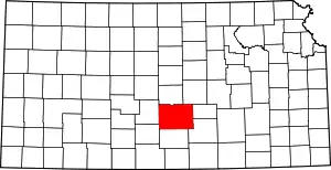 Map of Kansas highlighting Reno County | |
| Unincorporated communities | ||
| Ghost towns | ||
| Townships | ||
| Footnotes | †This populated place is designated a Census-Designated Place (CDP) by the United States Census Bureau | |
| ||
| Authority control |
|---|