South Iwo Jima
South Iwo Jima (南硫黄島, officially Minami-Iōtō, also frequently Minami-Iwō-jima,[1] Minami-Iōjima: “South Sulfur Island”) is the southernmost island of the Volcano Islands group of the Ogasawara Islands, 60 km south of Iwo Jima. It is now administered as part of the Ogasawara-mura of Tokyo and is unpopulated. Its pronounced Japanese name was changed on June 18, 2007 to Minami-Iōtō, the kanji unchanged. The next southern island (geologically), located 541 km (336 mi) away, is Farallon de Pajaros of the Northern Mariana Islands while Iwo Jima is roughly 60 km to the north.
| Native name: Japanese: 南硫黄島 | |
|---|---|
 Minami-Iōtō | |
 South Iwo Jima | |
| Geography | |
| Location | Pacific Ocean |
| Coordinates | 24°14′2″N 141°27′49″E |
| Archipelago | Volcano Islands |
| Area | 3.54 km2 (1.37 sq mi) |
| Coastline | 7.5 km (4.66 mi) |
| Highest elevation | 916 m (3005 ft) |
| Administration | |
Japan | |
| Prefecture | Tokyo |
| Subprefecture | Ogasawara Subprefecture |
| Village | Ogasawara |
| Demographics | |
| Population | 0 |
| Pop. density | 0/km2 (0/sq mi) |
Description
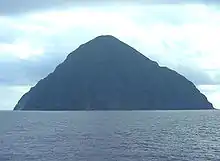
The island lies 1300 km south of Tokyo, 330 km SSW of Chichi-jima. Its area is 3.4 km2 and the shore length, 7.5 km. Along the shoreline there are few bays and inlets, and it is covered with mostly rocks and little sand. To the rear are sea cliffs that rise to 200 m in height. The peak on South Iwo Jima is the largest in the Ogasawara Islands at 913 m and its average slope angle is 45 degrees. The northwest side of this volcano, which has a relatively stable shape and is not eroding much, rises at a gentler incline of 30 degrees. Another defining feature of the island is that it does not have rivers, lakes, marshes or a freshwater system of any kind.
South Iwo Jima is part of a volcanic front which has been active for 2,588,000 years beginning in the Quaternary period and started to form as a result of volcanic activity in that period. Though it is not clear when it emerged as an island, rocks which have been gathered and analyzed show no signs of geomagnetic reversal, so it is believed that the island is no more than a few hundred thousands years old. It was discovered in October 1543 by Spanish sailor Bernardo de la Torre on board of carrack San Juan de Letrán when trying to return from Sarangani to New Spain.[2][3]
Environment
The island is a treasure house of precious animals and plants because it has not been developed historically due to its geographical isolation from mainland Japan, steep topography and severe weather conditions. The upper part of the island is often covered with clouds and fog, and the ecosystem differs from elevation to elevation. Because of this, the entire area of the island has been designated by the Japanese government as a Nature Conservation Area Of Forest Ecosystem In Ogasarawa-Islands and access to the island is strictly restricted, with only a limited number of scientists authorized by the government and mountain experts supporting them being allowed to land on the island. To date, serious academic research has been conducted only four times: in 1936, 1982, 2007, and 2017. Since all the survey routes are from the southwestern coast to the summit of the island, which is relatively easy to climb, most of the island is unexplored except for the coastal area. In 2017, the first drone survey of an unexplored region of the island was conducted.[4] The island forms part of the Kazan-retto islands Important Bird Area (IBA), designated by BirdLife International.[5]
In popular culture
Minami Iwo Jima is the location of Mahoutokoro, the Japanese school of witchcraft and wizardry in the fictional universe of Harry Potter. Mahoutokoro, the shiro or castle is located on the peak of extinct volcano and is constructed of pure white jade and described as having surrounded by stormy seas, without any Muggle inhabitants, and very close to a Japanese Air Force base.[6]
See also
- Iwo Jima
- Desert island
- List of islands
- Fukutoku-Okanoba, nearby ephemeral island
References
- Teikoku's Complete Atlas of Japan, Teikoku-Shoin Co., Ltd, Tokyo, ISBN 4-8071-0004-1
- Brand, Donald D. The Pacific Basin: A History of its Geographical Explorations The American Geographical Society (New York, 1967) p.123.
- Welsch, Bernard (Jun 2004). "Was Marcus Island Discovered by Bernardo de la Torre in 1543?". The Journal of Pacific History. Taylor & Francis. Ltd. 39 (1): 109–122. doi:10.1080/00223340410001684886.
- 世界自然遺産の小笠原諸島南硫黄島(みなみいおうとう)で10年ぶりの自然環境調査の結果について Tokyo Metropolitan Government
- "Kazan-retto islands". BirdLife Data Zone. BirdLife International. 2021. Retrieved 28 January 2021.
- "Mahoutokoro". Pottermore. Retrieved 2019-08-06.
External links
| Authority control |
|---|