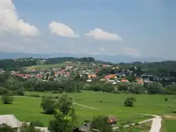
Spodnje Poljčane
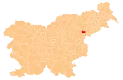
Spodnje Poljčane (pronounced [ˈspoːdnjɛ pɔlˈtʃaːnɛ]) is a settlement on the left bank of the Dravinja River in the Municipality of Poljčane in northeastern Slovenia. The area is part of the traditional region of Styria. It is now included with the rest of the municipality in the Drava Statistical Region.[2]
Spodnje Poljčane | |
|---|---|
 | |
 Spodnje Poljčane Location in Slovenia | |
| Coordinates: 46°18′38.85″N 15°35′6.64″E | |
| Country | |
| Traditional region | Styria |
| Statistical region | Drava |
| Municipality | Poljčane |
| Area | |
| • Total | 1.32 km2 (0.51 sq mi) |
| Elevation | 258.3 m (847.4 ft) |
| Population (2002) | |
| • Total | 577 |
| [1] | |
A Neo-Gothic chapel with a small belfry was built in the settlement in 1938.[3]
References
External links
| Settlements | Administrative centre: Poljčane
|  | ||||
|---|---|---|---|---|---|---|
| Landmarks |
| |||||
This article is issued from Wikipedia. The text is licensed under Creative Commons - Attribution - Sharealike. Additional terms may apply for the media files.
