Spodnji Duplek
Spodnji Duplek (pronounced [ˈspoːdnji ˈduːplɛk]) is a settlement and the administrative centre of the Municipality of Duplek in northeastern Slovenia. It lies on the left bank of the Drava River southeast of Maribor. The area is part of the traditional region of Styria. The municipality is now included in the Drava Statistical Region.[2]
Spodnji Duplek | |
|---|---|
 | |
 Spodnji Duplek Location in Slovenia | |
| Coordinates: 46°30′18.99″N 15°44′48.27″E | |
| Country | |
| Traditional region | Styria |
| Statistical region | Drava |
| Municipality | Duplek |
| Area | |
| • Total | 3.62 km2 (1.40 sq mi) |
| Elevation | 238.4 m (782.2 ft) |
| Population (2002) | |
| • Total | 1,177 |
| [1] | |
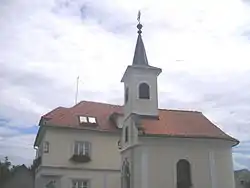
A Neo-Baroque chapel-shrine with a belfry at the crossroads in the centre of the settlement dates to 1860.[3]
References
External links
| Settlements | Administrative centre: Spodnji Duplek
|  | ||||
|---|---|---|---|---|---|---|
This article is issued from Wikipedia. The text is licensed under Creative Commons - Attribution - Sharealike. Additional terms may apply for the media files.