St Johns, South Australia
St Johns is a locality southeast of Kapunda in the northern Barossa Valley, South Australia. Originally a private subdivision on sections 1450, 1451 and 1533 of the Hundred of Belvidere,[1] the boundaries of the locality were formalised in 2000 and the name formally adopted based on long-established use.[2]
| St Johns South Australia | |||||||||||||||
|---|---|---|---|---|---|---|---|---|---|---|---|---|---|---|---|
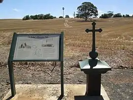 View towards the former church and reformatory from the cemetery | |||||||||||||||
 St Johns | |||||||||||||||
| Coordinates | 34°21′46″S 138°57′34″E | ||||||||||||||
| Postcode(s) | 5373 | ||||||||||||||
| LGA(s) | Light Regional Council | ||||||||||||||
| State electorate(s) | Stuart | ||||||||||||||
| Federal Division(s) | Barker | ||||||||||||||
| |||||||||||||||
The foundation stone for the St John the Evangelist church was laid on 2 April 1850, however the building was not completed until 30 April 1854. A school was opened in 1859, run by the Sisters of St Joseph of the Sacred Heart after 1868. From 1897, the school became a reformatory for girls until it closed in 1909.[3]
Belvidere
.jpg.webp)
Belvidere (34°21′14″S 138°56′55″E) is a historic locality overlapping the bounded locality of St Johns.[4] The settlement was a consequence of the opening of Belvidere Mine,[5] a marble mine adjacent to a crossing of the River Light (now McCarthy Bridge) and was likely named Belvidere by association to either the Hundred of Belvidere, the land administration division on the south east side of the river crossing in which the main settlement lay, or the Belvidere Range which overlooks the mine and west of the hundred.
References
- "Plan of Hundred of Belvidere, County of Light, South Australia" (Map). Hundred of Belvidere. Hundred of Belvidere, County of Light: State Library of South Australia. 1899. Retrieved 1 December 2017.
- "Property Location Browser (Search: St Johns, LOCB)". Government of South Australia. Retrieved 5 February 2016.
- "St John's, Johnstown, Kapunda". Flinders Ranges Research. Retrieved 9 February 2016.
- "Property Location Browser (Search: Belvidere, LOCU)". Government of South Australia. Retrieved 5 February 2016.
- "Local News". South Australian. XI (952). South Australia. 23 June 1848. p. 2. Retrieved 1 December 2017 – via National Library of Australia.
NEW MINE ON SECTION 1599.–This promising mine, we understand, is situated about sixty miles from Adelaide, on a section of land containing 642 acres (purchased by Messrs. M. I Smith and P. Levi, for selves and others at the public sale on Monday last), situated near the Ranges, between the Rivers Light and Gilbert, in a rich mining country. We have seen specimens of the carbonate and sulphurets of lead ores, which have a remarkable rich appearance, and we hear copper has also been found. The mine, we believe, has been named the "Belvidere." [...] Mr Finke started this day with four miners to the scene of operations.
.jpg)