Starksboro, Vermont
Starksboro is a town in Addison County, Vermont, United States. The population was 1,777 at the 2010 census.[3]
Starksboro, Vermont | |
|---|---|
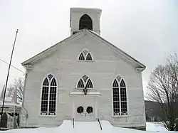 Starksboro Village Meeting House | |
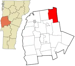 Location in Addison County and the state of Vermont. | |
| Coordinates: 44°12′22″N 73°1′3″W | |
| Country | United States |
| State | Vermont |
| County | Addison |
| Communities | Starksboro Jerusalem |
| Area | |
| • Total | 45.9 sq mi (118.8 km2) |
| • Land | 45.7 sq mi (118.3 km2) |
| • Water | 0.2 sq mi (0.5 km2) |
| Elevation | 2,028 ft (618 m) |
| Population (2010) | |
| • Total | 1,777 |
| • Density | 39/sq mi (15.0/km2) |
| Time zone | UTC-5 (Eastern (EST)) |
| • Summer (DST) | UTC-4 (EDT) |
| ZIP code | 05487 |
| Area code | 802 |
| FIPS code | 50-70075[1] |
| GNIS feature ID | 1462217[2] |
| Website | www |
Geography
Starksboro is located in the northeast corner of Addison County, along the western edge of the Green Mountains. Vermont Route 116 runs through the town center, leading north to Hinesburg and South Burlington and south to Bristol and East Middlebury. Vermont Route 17 crosses the southern part of the town, leading east across the Green Mountains to Mad River Glen ski area and the town of Waitsfield, and west to Bristol and the Champlain Valley.
According to the United States Census Bureau, Starksboro has a total area of 45.9 square miles (118.8 km2), of which 45.7 square miles (118.3 km2) is land and 0.19 square miles (0.5 km2), or 0.42%, is water.[3]
History
The Town was named after John Stark, a prominent Officer from the New Hampshire Militia during the Revolutionary War. The Robinson Elementary School is named in honor of Albert J. Robinson, who helped build the school.
Demographics
| Historical population | |||
|---|---|---|---|
| Census | Pop. | %± | |
| 1790 | 40 | — | |
| 1800 | 359 | 797.5% | |
| 1810 | 726 | 102.2% | |
| 1820 | 914 | 25.9% | |
| 1830 | 1,342 | 46.8% | |
| 1840 | 1,263 | −5.9% | |
| 1850 | 1,400 | 10.8% | |
| 1860 | 1,437 | 2.6% | |
| 1870 | 1,361 | −5.3% | |
| 1880 | 1,249 | −8.2% | |
| 1890 | 1,070 | −14.3% | |
| 1900 | 902 | −15.7% | |
| 1910 | 835 | −7.4% | |
| 1920 | 806 | −3.5% | |
| 1930 | 687 | −14.8% | |
| 1940 | 744 | 8.3% | |
| 1950 | 576 | −22.6% | |
| 1960 | 502 | −12.8% | |
| 1970 | 668 | 33.1% | |
| 1980 | 1,336 | 100.0% | |
| 1990 | 1,511 | 13.1% | |
| 2000 | 1,898 | 25.6% | |
| 2010 | 1,777 | −6.4% | |
| 2014 (est.) | 1,774 | [4] | −0.2% |
| U.S. Decennial Census[5] | |||
As of the census[1] of 2000, there were 1,898 people, 668 households, and 488 families residing in the town. The population density was 41.7 people per square mile (16.1/km2). There were 765 housing units at an average density of 16.8 per square mile (6.5/km2). The racial makeup of the town was 96.63% White, 0.21% African American, 0.26% Native American, 0.68% Asian, 0.05% Pacific Islander, 0.05% from other races, and 2.11% from two or more races. Hispanic or Latino of any race were 0.21% of the population.
There were 668 households, out of which 42.8% had children under the age of 18 living with them, 59.1% were married couples living together, 8.2% had a female householder with no husband present, and 26.8% were non-families. 17.8% of all households were made up of individuals, and 4.6% had someone living alone who was 65 years of age or older. The average household size was 2.84 and the average family size was 3.26.
In the town, the age distribution of the population shows 30.6% under the age of 18, 6.9% from 18 to 24, 34.4% from 25 to 44, 22.3% from 45 to 64, and 5.8% who were 65 years of age or older. The median age was 34 years. For every 100 females, there were 96.7 males. For every 100 females age 18 and over, there were 100.8 males.
The median income for a household in the town was $44,559, and the median income for a family was $46,771. Males had a median income of $31,424 versus $23,828 for females. The per capita income for the town was $17,688. About 6.9% of families and 9.8% of the population were below the poverty line, including 12.0% of those under age 18 and 9.3% of those age 65 or over.
Notable people
- Phineas D. Ballou, mayor of Burlington, Vermont, 1868-1870[6]
- Barbara Cochran, Olympic slalom gold medalist (1972)
- Thacher Hurd, Children Author, spends summers in family home in town.
- David Mason, stonemason
- Ryan Cochran-Siegle, Olympic slalom competitor
References
- "U.S. Census website". United States Census Bureau. Retrieved 2008-01-31.
- "US Board on Geographic Names". United States Geological Survey. 2007-10-25. Retrieved 2008-01-31.
- "Geographic Identifiers: 2010 Demographic Profile Data (G001): Starksboro town, Addison County, Vermont". U.S. Census Bureau, American Factfinder. Archived from the original on February 12, 2020. Retrieved August 30, 2013.
- "Annual Estimates of the Resident Population for Incorporated Places: April 1, 2010 to July 1, 2014". Archived from the original on May 23, 2015. Retrieved June 4, 2015.
- "U.S. Decennial Census". United States Census Bureau. Retrieved May 16, 2015.
- Bigelow, George H.; Underwood, Levi; Nichols, Sayles (1877). "In Memoriam: Phineas Dodge Ballou". Proceedings of the Supreme Council, Ancient and Accepted Scottish Rite, Northern Jurisdiction. Binghamton, NY: Republican Print. pp. 146–151 – via Google Books.
External links
- Town of Starksboro official website
- Starksboro Historical Society
- Starksboro Village Meetinghouse
- Robinson Elementary School
Municipalities and communities of Addison County, Vermont, United States | ||
|---|---|---|
| City | 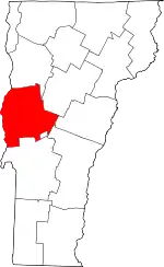 Map of Vermont highlighting Addison County | |
| Towns | ||
| CDPs | ||
| Other communities | ||
| ||
| Authority control |
|---|