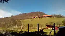
Stebnícka Huta
Stebnícka Huta is a village and municipality in Bardejov District in the Prešov Region of north-east Slovakia.
Stebnícka Huta | |
|---|---|
Municipality | |
 | |
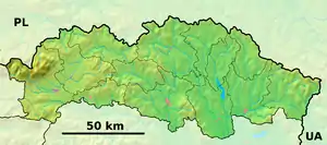 Stebnícka Huta Location of Stebnícka Huta in the Prešov Region  Stebnícka Huta Location of Stebnícka Huta in Slovakia | |
| Coordinates: 49°25′N 21°15′E | |
| Country | |
| Region | Prešov |
| District | Bardejov |
| First mentioned | 1600 |
| Area | |
| • Total | 9.433 km2 (3.642 sq mi) |
| Elevation | 505 m (1,657 ft) |
| Population | |
| • Total | 255 |
| • Density | 27/km2 (70/sq mi) |
| Time zone | UTC+1 (CET) |
| • Summer (DST) | UTC+2 (CEST) |
| Postal code | 086 33 (pošta Zborov) |
| Area code(s) | 421-54 |
| Car plate | BJ |
| Website | www |
History
In historical records the village was first mentioned in 1600
Geography
The municipality lies at an altitude of 505 metres and covers an area of 9.433 km². It has a population of about 255 people.
External links
 Media related to Stebnícka Huta at Wikimedia Commons
- Official website

- http://www.statistics.sk/mosmis/eng/run.html
This article is issued from Wikipedia. The text is licensed under Creative Commons - Attribution - Sharealike. Additional terms may apply for the media files.