Stirling Old Bridge
Stirling Old Bridge is a stone bridge which crosses the River Forth. For over 300 years it provided the lowest crossing point of the Forth and so had strategic importance.[1]
Old Bridge | |
|---|---|
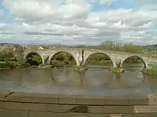 Stirling Old Bridge, viewed from the road bridge | |
| Coordinates | 56°7′43.03″N 3°56′12.78″W |
| Carries | foot and bicycle traffic |
| Crosses | River Forth |
| Locale | Stirling |
| Heritage status | Category A listed building |
| Characteristics | |
| Material | Stone |
| Total length | 268 feet (82 m) |
| No. of spans | 4 |
| History | |
| Construction end | circa 1500 |
| Location | |
| |
History
The stone bridge was constructed on rubble foundations around 1500[2] and replaced earlier wooden bridges, including that on which the Battle of Stirling Bridge was fought.
The bridge originally had arches at either end and a defensive gate at the end nearer the burgh. Tolls were levied on goods being taken across the bridge.[3]:114
In December 1745 General Blakeney, lieutenant governor of Stirling Castle, had one of the bridge arches destroyed to hinder the movement of the Jacobite Army.[3]:160 The destroyed arch was rebuilt in 1749.[4][5]
In May 1833 the adjacent new road bridge was opened to traffic and the Old Bridge was closed to wheeled traffic.[1][3]:196
The bridge was designated as a Category A Listed Building in 1965.[2]
References
- "Old Bridge". Gazetteer for Scotland.
- Historic Environment Scotland. "Stirling, Old Bridge (LB41129)". Retrieved 26 October 2020.
- Mair, Craig (1990). Stirling: The Royal Burgh. John Donald. ISBN 0859764206.
- "Statement of significance: Stirling Old Bridge". Historic Environment Scotland.
- Historic Environment Scotland. "Stirling, Causewayhead, Bridegehaugh Road, Old Bridge (46195)". Canmore. Retrieved 26 October 2020.
External links
| Wikimedia Commons has media related to Stirling Old Bridge. |