Stjørdalen (municipality)
Stjørdalen is a former municipality in the old Nordre Trondhjem county in Norway. The 2,253-square-kilometre (870 sq mi) municipality existed from 1838 until its dissolution in 1850. The municipality covered the whole Stjørdalen valley in what is now the municipalities of Stjørdal and Meråker in Trøndelag county. The administrative centre was located at Værnes where Værnes Church is located.[2][3]
Stjørdalen herad | |
|---|---|
 Nord-Trøndelag within Norway | |
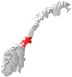
 Stjørdalen within Nord-Trøndelag | |
| Coordinates: 63.4570°N 11.0078°E | |
| Country | Norway |
| County | Nord-Trøndelag |
| District | Stjørdalen |
| Established | 1 Jan 1838 |
| Disestablished | 1850 |
| Administrative centre | Værnes |
| Area | |
| • Total | 2,253 km2 (870 sq mi) |
| *Area at municipal dissolution. | |
| Population (1850) | |
| • Total | 11,643 |
| • Density | 5.2/km2 (13/sq mi) |
| Demonym(s) | stjørdaling[1] |
| Time zone | UTC+01:00 (CET) |
| • Summer (DST) | UTC+02:00 (CEST) |
| ISO 3166 code | NO-1714 |
| Created as | Formannskapsdistrikt in 1838 |
| Succeeded by | Øvre Stjørdal and Nedre Stjørdal in 1850 |
History
The municipality of Stjørdalen was established on 1 January 1838 (see formannskapsdistrikt). In 1850, the municipality of Stjørdalen was divided into Øvre Stjørdal (population: 5,100) and Nedre Stjørdal (population: 6,543).[4]
References
- "Navn på steder og personer: Innbyggjarnamn" (in Norwegian). Språkrådet.
- "Prestegjeld og sogn i Nord-Trøndelag" (in Norwegian). Arkivverket. 2017-07-04. Retrieved 2018-03-24.
- Helland, Amund (1909). "Meraker, Hegre, Laanke, Stjørdalen, & Skatval herreder". Norges land og folk: Nordre Trondhjems amt (in Norwegian). Norway: H. Aschehoug & Company. pp. 30–117. Retrieved 2018-03-23.
- Jukvam, Dag (1999). "Historisk oversikt over endringer i kommune- og fylkesinndelingen" (PDF) (in Norwegian). Statistisk sentralbyrå.
 |
|  | |||||||||||||||||||||||
||
This article is issued from Wikipedia. The text is licensed under Creative Commons - Attribution - Sharealike. Additional terms may apply for the media files.