Stoney Creek (Delaware River tributary in Delaware)
Stenkil Creek is a 2.76 mi (4.44 km) long second order tributary to the Delaware River in New Castle County, Delaware.
| Stenkil Creek Tributary to Delaware River | |
|---|---|
 Eagle Falls - Waterfall in Northern Delaware along Stenkil Creek | |
 Location of Stenkil Creek Mouth  Stoney Creek (Delaware River tributary in Delaware) (the United States) | |
| Location | |
| Country | United States |
| State | Delaware |
| County | New Castle |
| Physical characteristics | |
| Source | Perkins Run divide |
| • location | Westwood, Delaware |
| • coordinates | 39°48′18″N 075°30′07″W[1] |
| • elevation | 340 ft (100 m)[2] |
| Mouth | Delaware River |
• location | Bellevue, Delaware |
• coordinates | 39°46′26″N 075°28′48″W[1] |
• elevation | 0 ft (0 m)[2] |
| Length | 4.6 mi (7.4 km)[3] |
| Basin size | 2.36 square miles (6.1 km2)[4] |
| Discharge | |
| • average | 3.37 cu ft/s (0.095 m3/s) at mouth with Stenkil Creek[4] |
| Basin features | |
| Progression | southeast |
| River system | Delaware River |
| Tributaries | |
| • left | Boulder Run |
| • right | Jacksons Creek |
| Waterbodies | Bellevue Lake |
| Waterfalls | Eagle Falls and Fox Falls |
| Bridges | Marsh Road Veale Road Silverside Road I-95 Carr Road Philadelphia Pike US 13 I-495 |
Variant names
According to the Geographic Names Information System, it has also been known historically as:[1]
- Fransens Creek
- Oele Fransens Creek
- Quarry Creek
- Quarryville Creek
- Stenkil
- Stony Creek
Course
Stoney Creek rises on the Perkins Run divide Westwood, Delaware in New Castle County, Delaware. Stoney Creek then flows southeast to meet the Delaware River at Bellevue, Delaware.[2]
Watershed
Stenkil Creek drains 2.36 square miles (6.1 km2) of area, receives about 46.8 in/year of precipitation, has a topographic wetness index of 475.50 and is about 17.6% forested.[4]
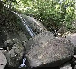
 Fox Falls is a ten-foot waterfall located in Bellevue State Park.
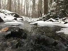 Stenkil Creek near Allen Tract Park in February.
See also
References
- "GNIS Detail - Stenkil Creek". geonames.usgs.gov. US Geological Survey. Retrieved 27 February 2020.
- "Stenkil Creek Topo Map, New Castle County DE (Marcus Hook Area)". TopoZone. Locality, LLC. Retrieved 27 February 2020.
- "ArcGIS Web Application". epa.maps.arcgis.com. US EPA. Retrieved 27 February 2020.
- "Stenkil Creek Watershed Report". Waters Geoviewer. US EPA. Retrieved 27 February 2020.
Dover (capital) | ||
| Topics |
|  |
| Society |
| |
| Cities | ||
| Towns |
| |
| Counties | ||
This article is issued from Wikipedia. The text is licensed under Creative Commons - Attribution - Sharealike. Additional terms may apply for the media files.