Stranda, Møre og Romsdal
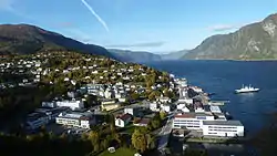
Stranda is the administrative centre of Stranda Municipality in Møre og Romsdal county, Norway. The village is located on the western shore of the Storfjorden.[3] The 2.4-square-kilometre (590-acre) village has a population (2018) of 2,969 and a population density of 1,237 inhabitants per square kilometre (3,200/sq mi). This is the largest urban area in the municipality.[1]
Stranda | |
|---|---|
Village | |
 View of the village | |
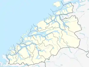 Stranda Location in Møre og Romsdal  Stranda Stranda (Norway) | |
| Coordinates: 62.3086°N 6.9372°E | |
| Country | Norway |
| Region | Western Norway |
| County | Møre og Romsdal |
| District | Sunnmøre |
| Municipality | Stranda Municipality |
| Area | |
| • Total | 2.4 km2 (0.9 sq mi) |
| Elevation | 30 m (100 ft) |
| Population (2018)[1] | |
| • Total | 2,969 |
| • Density | 1,237/km2 (3,200/sq mi) |
| Time zone | UTC+01:00 (CET) |
| • Summer (DST) | UTC+02:00 (CEST) |
| Post Code | 6200 Stranda |
The village is the shopping and industry center of the municipality. It lies along Norwegian County Road 60, and there is a ferry connection to the village of Liabygda, across the fjord. The village of Helsem lies about 2 kilometres (1.2 mi) south of Stranda. Stranda Church is located in Stranda. The newspaper Sunnmøringen is published in Stranda.[4]
At 10:00 p.m. on 8 January 1731, a landslide with an estimated volume of 6,000,000 cubic metres (7,800,000 cubic yards) fell from a height of 500 metres (1,600 ft) on the slope of the mountain Skafjell into the Storfjorden opposite Stranda. The slide generated a megatsunami 100 metres (328 ft) in height that struck Stranda, flooding the area for 100 metres (328 ft) inland and destroying the church and all but two boathouses, as well as many boats. Damaging waves struck as far as way as Ørskog. The waves killed 17 people. It was the first natural disaster in Norway to be reported and documented in historic time.[5]
References
- Statistisk sentralbyrå (1 January 2018). "Urban settlements. Population and area, by municipality".
- "Stranda (Møre og Romsdal)". yr.no. Retrieved 2019-08-25.
- Store norske leksikon. "Stranda – tettstedet" (in Norwegian). Retrieved 2013-06-29.
- Store norske leksikon: Sunnmøringen.
- Hoel, Christer, "The Skafjell Rock Avalanche in 1731," fjords.com Retrieved 23 June 2020