Ørskog
Ørskog is a former municipality in Møre og Romsdal county, Norway. It was part of the Sunnmøre region. The administrative centre was the village of Sjøholt. The other main village was Vaksvika, about 7.5 kilometres (4.7 mi) south of Sjøholt. The European Route E39/E136 highway runs through the municipality, connecting the towns of Ålesund and Molde. Rauma Group is the largest company in Ørskog in terms of turnover.
Ørskog kommune | |
|---|---|
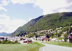 View of Sjøholt | |
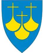
 Coat of arms  Møre og Romsdal within Norway | |
 Ørskog within Møre og Romsdal | |
| Coordinates: 62°28′44″N 06°53′07″E | |
| Country | Norway |
| County | Møre og Romsdal |
| District | Sunnmøre |
| Established | 1 Jan 1838 |
| Disestablished | 1 Jan 2020 |
| Administrative centre | Sjøholt |
| Government | |
| • Mayor (2015-2019) | Knut Helge Harstad (H) |
| Area | |
| • Total | 132.35 km2 (51.10 sq mi) |
| • Land | 128.90 km2 (49.77 sq mi) |
| • Water | 3.45 km2 (1.33 sq mi) 2.6% |
| Area rank | 363 in Norway |
| *Area at municipal dissolution. | |
| Population (2018) | |
| • Total | 2,267 |
| • Rank | 309 in Norway |
| • Density | 17.6/km2 (46/sq mi) |
| • Change (10 years) | 7.0% |
| Demonym(s) | Ørskogbygdar[1] |
| Time zone | UTC+01:00 (CET) |
| • Summer (DST) | UTC+02:00 (CEST) |
| ISO 3166 code | NO-1523 |
| Official language form | Nynorsk[2] |
| Created as | Formannskapsdistrikt in 1838 |
| Succeeded by | Ålesund in 2020 |
| Website | orskog |
At the time if its dissolution in 2020, the 132-square-kilometre (51 sq mi) municipality was the 363rd largest by area out of the 422 municipalities in Norway. Ørskog is the 309th most populous municipality in Norway with a population of 2,267. The municipality's population density is 17.6 inhabitants per square kilometre (46/sq mi) and its population has increased by 7% over the last decade.[3][4]
General information
Ørskog was established as a municipality on 1 January 1838 (see formannskapsdistrikt law). On 1 August 1883, the southwestern district of Ørskog (most of Ørskog on the southwestern side of the Storfjorden except for the Søvik and Ramstaddalen areas) was separated to form the new Søkelven Municipality. This left Ørskog with 1,735 inhabitants. On 1 June 1955, the Søvik and Ramstaddalen areas of Ørskog (south of the Storfjorden) were administratively transferred to Sykkylven Municipality. On 1 January 1965, Skodje Municipality (to the west) and Stordal Municipality (to the south) were merged into Ørskog to form a new, larger Ørskog Municipality. This merger was not long-lived. On 1 January 1977, the three municipalities were separated again.[5]
On 1 January 2020, the municipality of Ørskog was merged with Haram Municipality, Skodje Municipality, Sandøy Municipality, and Ålesund Municipality to form one large municipality of Ålesund.[6]
Name
The municipality (originally the parish) is named after the old Ørskog farm (Old Norse: Øyraskógr), since the first Ørskog Church was built there. The first element is the plural genitive case of øyrr which means "shoal" and the last element is skógr which means "wood" or "forest".[7]
Coat of arms
The coat of arms was granted on 11 November 1983. The arms show a gold-colored wooden pole in the center with black and white ermine on each side of the pole. This was chosen as a symbol for forestry and fur farming. In the 17th century, the municipality exported many tall trees to the Dutch Republic, where they were used for shipbuilding. The ermine is a canting for the many animals in the forests.[8]
Churches
The Church of Norway had one parish (sokn) within the municipality of Ørskog. It is part of the Austre Sunnmøre prosti (deanery) in the Diocese of Møre.
| Parish (sokn) | Church name | Location of the church | Year built |
|---|---|---|---|
| Ørskog | Ørskog Church | Sjøholt | 1873 |
Geography
The municipality lies on the north shore of the Storfjorden, and it is bordered by Skodje Municipality to the west, Vestnes Municipality to the north and east, and Stordal Municipality to the south. Most of the population lives along the shore or in the small valleys that stretch inland from the fjord. The eastern part of the municipality is mountainous.
At 10:00 p.m. on 8 January 1731, a landslide with a volume of possibly 6,000,000 cubic metres (7,800,000 cu yd) fell from the mountain Skafjell from a height of 500 metres (1,600 ft) into the Storfjorden opposite Stranda. The slide generated a megatsunami 100 metres (328 ft) in height that struck Stranda, and damaging waves of lesser size traveled as far as Ørskog. It was the first natural disaster to be reported and documented in Norway in historic time.[9]
Government
All municipalities in Norway, including Ørskog, are responsible for primary education (through 10th grade), outpatient health services, senior citizen services, unemployment and other social services, zoning, economic development, and municipal roads. The municipality is governed by a municipal council of elected representatives, which in turn elect a mayor.[10] The municipality falls under the Sunnmøre District Court and the Frostating Court of Appeal.
Municipal council
The municipal council (Kommunestyre) of Ørskog is made up of 17 representatives that are elected to four year terms. The party breakdown for the final municipal council was as follows:
| Party Name (in Nynorsk) | Number of representatives | |
|---|---|---|
| Labour Party (Arbeidarpartiet) | 4 | |
| Progress Party (Framstegspartiet) | 4 | |
| Conservative Party (Høgre) | 3 | |
| Centre Party (Senterpartiet) | 2 | |
| Joint list of the Liberal Party (Venstre) and Christian Democratic Party (Kristelig Folkeparti) | 4 | |
| Total number of members: | 17 | |
| Party Name (in Nynorsk) | Number of representatives | |
|---|---|---|
| Labour Party (Arbeidarpartiet) | 4 | |
| Progress Party (Framstegspartiet) | 5 | |
| Conservative Party (Høgre) | 2 | |
| Centre Party (Senterpartiet) | 4 | |
| Joint list of the Liberal Party (Venstre) and Christian Democratic Party (Kristelig Folkeparti) | 2 | |
| Total number of members: | 17 | |
| Party Name (in Nynorsk) | Number of representatives | |
|---|---|---|
| Labour Party (Arbeidarpartiet) | 4 | |
| Progress Party (Framstegspartiet) | 4 | |
| Conservative Party (Høgre) | 3 | |
| Joint list of the Centre Party (Senterpartiet), Christian Democratic Party (Kristeleg Folkeparti), and Liberal Party (Venstre) | 6 | |
| Total number of members: | 17 | |
| Party Name (in Nynorsk) | Number of representatives | |
|---|---|---|
| Labour Party (Arbeidarpartiet) | 3 | |
| Progress Party (Framstegspartiet) | 5 | |
| Conservative Party (Høgre) | 4 | |
| Centre Party (Senterpartiet) | 2 | |
| Joint list of the Liberal Party (Venstre) and Christian Democratic Party (Kristelig Folkeparti) | 5 | |
| Total number of members: | 19 | |
| Party Name (in Nynorsk) | Number of representatives | |
|---|---|---|
| Labour Party (Arbeidarpartiet) | 4 | |
| Progress Party (Framstegspartiet) | 2 | |
| Conservative Party (Høgre) | 6 | |
| Pensioners' Party (Pensjonistpartiet) | 1 | |
| Centre Party (Senterpartiet) | 4 | |
| Liberal Party (Venstre) | 2 | |
| Total number of members: | 19 | |
| Party Name (in Nynorsk) | Number of representatives | |
|---|---|---|
| Labour Party (Arbeidarpartiet) | 3 | |
| Progress Party (Framstegspartiet) | 2 | |
| Conservative Party (Høgre) | 2 | |
| Pensioners' Party (Pensjonistpartiet) | 1 | |
| Centre Party (Senterpartiet) | 4 | |
| Liberal Party (Venstre) | 5 | |
| Sjøholt school area (Sjøholt skulekrins) | 2 | |
| Total number of members: | 19 | |
| Party Name (in Nynorsk) | Number of representatives | |
|---|---|---|
| Labour Party (Arbeidarpartiet) | 5 | |
| Progress Party (Framstegspartiet) | 3 | |
| Conservative Party (Høgre) | 4 | |
| Christian Democratic Party (Kristeleg Folkeparti) | 2 | |
| Centre Party (Senterpartiet) | 4 | |
| Liberal Party (Venstre) | 1 | |
| Total number of members: | 19 | |
| Party Name (in Nynorsk) | Number of representatives | |
|---|---|---|
| Labour Party (Arbeidarpartiet) | 3 | |
| Progress Party (Framstegspartiet) | 5 | |
| Conservative Party (Høgre) | 3 | |
| Christian Democratic Party (Kristeleg Folkeparti) | 3 | |
| Centre Party (Senterpartiet) | 3 | |
| Liberal Party (Venstre) | 2 | |
| Total number of members: | 19 | |
| Party Name (in Nynorsk) | Number of representatives | |
|---|---|---|
| Labour Party (Arbeidarpartiet) | 3 | |
| Progress Party (Framstegspartiet) | 3 | |
| Conservative Party (Høgre) | 4 | |
| Christian Democratic Party (Kristeleg Folkeparti) | 3 | |
| Centre Party (Senterpartiet) | 3 | |
| Liberal Party (Venstre) | 3 | |
| Total number of members: | 19 | |
| Party Name (in Nynorsk) | Number of representatives | |
|---|---|---|
| Labour Party (Arbeidarpartiet) | 3 | |
| Progress Party (Framstegspartiet) | 1 | |
| Conservative Party (Høgre) | 4 | |
| Christian Democratic Party (Kristeleg Folkeparti) | 3 | |
| Centre Party (Senterpartiet) | 3 | |
| Liberal Party (Venstre) | 2 | |
| Election list in Ørskog (Valliste i Ørskog) | 2 | |
| Non-party election list in Vaksvik (Upolitisk valliste i Vaksvik) | 1 | |
| Total number of members: | 19 | |
| Party Name (in Nynorsk) | Number of representatives | |
|---|---|---|
| Labour Party (Arbeidarpartiet) | 2 | |
| Christian Democratic Party (Kristeleg Folkeparti) | 4 | |
| Centre Party (Senterpartiet) | 4 | |
| Liberal Party (Venstre) | 2 | |
| Non-party election list for Ørskog (Upolitisk Valliste for Ørskog) | 3 | |
| Election list for Skodje (Valliste for Skodje) | 8 | |
| Election list for Stordal and Dyrkorn (Valliste for Stordal og Dyrkorn) | 6 | |
| Total number of members: | 29 | |
| Party Name (in Nynorsk) | Number of representatives | |
|---|---|---|
| Labour Party (Arbeidarpartiet) | 3 | |
| Conservative Party (Høgre) | 1 | |
| Christian Democratic Party (Kristeleg Folkeparti) | 3 | |
| Centre Party (Senterpartiet) | 4 | |
| Liberal Party (Venstre) | 2 | |
| Local List(s) (Lokale lister) | 16 | |
| Total number of members: | 29 | |
| Party Name (in Nynorsk) | Number of representatives | |
|---|---|---|
| Labour Party (Arbeidarpartiet) | 3 | |
| Conservative Party (Høgre) | 1 | |
| Christian Democratic Party (Kristeleg Folkeparti) | 3 | |
| Centre Party (Senterpartiet) | 3 | |
| Liberal Party (Venstre) | 2 | |
| Local List(s) (Lokale lister) | 17 | |
| Total number of members: | 29 | |
| Party Name (in Nynorsk) | Number of representatives | |
|---|---|---|
| Labour Party (Arbeidarpartiet) | 4 | |
| Conservative Party (Høgre) | 3 | |
| Christian Democratic Party (Kristeleg Folkeparti) | 2 | |
| Centre Party (Senterpartiet) | 4 | |
| Liberal Party (Venstre) | 3 | |
| Local List(s) (Lokale lister) | 1 | |
| Total number of members: | 17 | |
| Party Name (in Nynorsk) | Number of representatives | |
|---|---|---|
| Labour Party (Arbeidarpartiet) | 3 | |
| Local List(s) (Lokale lister) | 14 | |
| Total number of members: | 17 | |
| Party Name (in Nynorsk) | Number of representatives | |
|---|---|---|
| Local List(s) (Lokale lister) | 17 | |
| Total number of members: | 17 | |
| Party Name (in Nynorsk) | Number of representatives | |
|---|---|---|
| Local List(s) (Lokale lister) | 16 | |
| Total number of members: | 16 | |
| Party Name (in Nynorsk) | Number of representatives | |
|---|---|---|
| Labour Party (Arbeidarpartiet) | 3 | |
| Local List(s) (Lokale lister) | 13 | |
| Total number of members: | 16 | |
| Party Name (in Nynorsk) | Number of representatives | |
|---|---|---|
| List of workers, fishermen, and small farmholders (Arbeidarar, fiskarar, småbrukarar liste) | 3 | |
| Local List(s) (Lokale lister) | 13 | |
| Total number of members: | 16 | |
| Party Name (in Nynorsk) | Number of representatives | |
|---|---|---|
| Labour Party (Arbeidarpartiet) | 3 | |
| Local List(s) (Lokale lister) | 13 | |
| Total number of members: | 16 | |
References
- "Navn på steder og personer: Innbyggjarnamn" (in Norwegian). Språkrådet.
- "Forskrift om målvedtak i kommunar og fylkeskommunar" (in Norwegian). Lovdata.no.
- Statistisk sentralbyrå (2018). "Table: 06913: Population 1 January and population changes during the calendar year (M)" (in Norwegian). Retrieved 2019-08-10.
- Statistisk sentralbyrå. "09280: Area of land and fresh water (km²) (M)" (in Norwegian). Retrieved 2019-08-10.
- Jukvam, Dag (1999). "Historisk oversikt over endringer i kommune- og fylkesinndelingen" (PDF) (in Norwegian). Statistisk sentralbyrå.
- "Nye Ålesund" (in Norwegian). Retrieved 2017-10-19.
- Rygh, Oluf (1908). Norske gaardnavne: Romsdals amt (in Norwegian) (13 ed.). Kristiania, Norge: W. C. Fabritius & sønners bogtrikkeri. p. 152.
- "Civic heraldry of Norway - Norske Kommunevåpen". Heraldry of the World. Retrieved 2019-08-11.
- Hoel, Christer, "The Skafjell Rock Avalanche in 1731," fjords.com Retrieved 23 June 2020
- Hansen, Tore, ed. (2016-05-12). "kommunestyre". Store norske leksikon (in Norwegian). Kunnskapsforlaget. Retrieved 2019-04-06.
- "Table: 04813: Members of the local councils, by party/electoral list at the Municipal Council election (M)" (in Norwegian). Statistics Norway.
- "Tall for Norge: Kommunestyrevalg 2011 - Møre og Romsdal" (in Norwegian). Statistics Norway. Retrieved 2019-10-19.
- "Kommunestyrevalget 1995" (PDF) (in Norwegian). Oslo-Kongsvinger: Statistisk sentralbyrå. 1996. Retrieved 2020-04-26.
- "Kommunestyrevalget 1991" (PDF) (in Norwegian). Oslo-Kongsvinger: Statistisk sentralbyrå. 1993. Retrieved 2020-04-26.
- "Kommunestyrevalget 1987" (PDF) (in Norwegian). Oslo-Kongsvinger: Statistisk sentralbyrå. 1988. Retrieved 2020-04-26.
- "Kommunestyrevalget 1983" (PDF) (in Norwegian). Oslo-Kongsvinger: Statistisk sentralbyrå. 1984. Retrieved 2020-04-26.
- "Kommunestyrevalget 1979" (PDF) (in Norwegian). Oslo: Statistisk sentralbyrå. 1979. Retrieved 2020-04-26.
- "Kommunevalgene 1975" (PDF) (in Norwegian). Oslo: Statistisk sentralbyrå. 1977. Retrieved 2020-04-26.
- "Kommunevalgene 1972" (PDF) (in Norwegian). Oslo: Statistisk sentralbyrå. 1973. Retrieved 2020-04-26.
- "Kommunevalgene 1967" (PDF) (in Norwegian). Oslo: Statistisk sentralbyrå. 1967. Retrieved 2020-04-26.
- "Kommunevalgene 1963" (PDF) (in Norwegian). Oslo: Statistisk sentralbyrå. 1964. Retrieved 2020-04-26.
- "Kommunevalgene og Ordførervalgene 1959" (PDF) (in Norwegian). Oslo: Statistisk sentralbyrå. 1960. Retrieved 2020-04-26.
- "Kommunevalgene og Ordførervalgene 1955" (PDF) (in Norwegian). Oslo: Statistisk sentralbyrå. 1957. Retrieved 2020-04-26.
- "Kommunevalgene og Ordførervalgene 1951" (PDF) (in Norwegian). Oslo: Statistisk sentralbyrå. 1952. Retrieved 2020-04-26.
- "Kommunevalgene og Ordførervalgene 1947" (PDF) (in Norwegian). Oslo: Statistisk sentralbyrå. 1948. Retrieved 2020-04-26.
- "Kommunevalgene og Ordførervalgene 1945" (PDF) (in Norwegian). Oslo: Statistisk sentralbyrå. 1947. Retrieved 2020-04-26.
- "Kommunevalgene og Ordførervalgene 1937" (PDF) (in Norwegian). Oslo: Statistisk sentralbyrå. 1938. Retrieved 2020-04-26.
External links
 Media related to Ørskog at Wikimedia Commons
 Møre og Romsdal travel guide from Wikivoyage
- Municipal fact sheet from Statistics Norway (in Norwegian)
Møre og Romsdal county, Norway | |||||
|---|---|---|---|---|---|
 |
|  | |||
| Authority control |
|---|