Strongyli Megistis
Strongyli Megistis (Greek: Στρογγυλή Μεγίστης), also called plainly Strongyli or Ypsili, is a Greek islet[2][3] which lies in the eastern Mediterranean Sea,[4][5] about four kilometers south-east of the island of Kastellorizo. The island is about 1.5 kilometres (0.9 miles) long, and up to 700 metres (2,300 ft) wide. It covers an area of about 0.9 square kilometres (0.3 sq mi). It is rather flat and covered with macchia. The islet has no permanent residents.
Strongyli Megistis
Στρογγυλή Μεγίστης | |
|---|---|
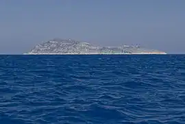 The islet of Strongyli seen from southwest | |
 Strongyli Megistis | |
| Coordinates: 36°7′N 29°38′E | |
| Country | Greece |
| Administrative region | South Aegean |
| Regional unit | Rhodes |
| Area | |
| • Total | 0.9 km2 (0.3 sq mi) |
| Population (2011)[1] | |
| • Total | 0 |
| • Density | 0.0/km2 (0.0/sq mi) |
| Time zone | UTC+2 (EET) |
| • Summer (DST) | UTC+3 (EEST) |
| Postal code | 851 11 |
| Area code(s) | 22460 |
| Vehicle registration | ΚΧ, ΡΟ, ΡΚ |
Strongyli is the easternmost Greek territory. Administratively it is part of the Municipality of Megisti. According to the 2011 census the island is deserted.[6] It has a lighthouse, which has the characteristic of being the easternmost building in Greece. There is also a cargo aerial cableway which is used by the army to transport cargo from the area of disembarkation to the Surveillance Outpost of Stroghyli.[7][8]
See also
References
- "Απογραφή Πληθυσμού - Κατοικιών 2011. ΜΟΝΙΜΟΣ Πληθυσμός" (in Greek). Hellenic Statistical Authority.
- Wire, Elinor De; Reyes-Pergioudakis, Dolores (2010). The Lighthouses of Greece. Pineapple Press Inc. ISBN 978-1-56164-452-0.
- Baumgarten, Monika I. (1987). Baedeker's Greek Islands. Prentice Hall Press. ISBN 978-0-13-058132-7.
- Department, Great Britain Hydrographic (1987). Mediterranean Pilot: Aegean Sea and approaches with adjacent coasts of Greece and Turkey. Hydrographer of the Navy.
- Wittke, A. A.; Mechanics, International Society for Rock (1982). Rock mechanics: caverns and pressure shafts. A.A. Balkema. ISBN 978-90-6191-232-3.
- "Greek Population Census, 2011". Retrieved 25 January 2014.
- http://www.army.gr/default.php?pname=Article&art_id=93955&cat_id=14&la=2
- "cargo cable way". TektInn. Retrieved 2020-06-11.
- "Vrachonisída Strongylí". geoview.info. Retrieved 20 September 2020.