Suan Luang District
Suan Luang (Thai: สวนหลวง, pronounced [sǔa̯n lǔa̯ŋ]) is one of the 50 districts (khet) of Bangkok, Thailand. It is bounded by other Bangkok districts (from north clockwise): Bang Kapi, Saphan Sung, Prawet, Phra Khanong, and Watthana.
Suan Luang
สวนหลวง | |
|---|---|
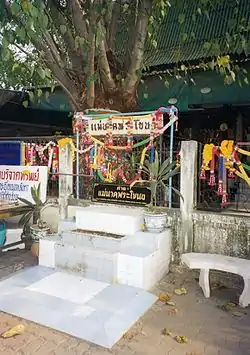 Outer perimeter of the shrine to Mae Nak Phra Khanong at Wat Mahabut. | |
 District location in Bangkok | |
| Coordinates: 13°43′49″N 100°39′5″E | |
| Country | Thailand |
| Province | Bangkok |
| Seat | Phatthanakan |
| Khwaengs | 3 |
| District established | 14 January 1994 |
| Area | |
| • Total | 23.678 km2 (9.142 sq mi) |
| Population (2017) | |
| • Total | 122,534[1] |
| • Density | 5,175.01/km2 (13,403.2/sq mi) |
| Time zone | UTC+7 (ICT) |
| Postal code | 10250 |
| Geocode | 1034 |
History
Suan Luang was a sub-district of Phra Khanong District. When Phra Khanong District was split into smaller districts on 9 November 1989, Suan Luang became part of the new Prawet District. On 14 January 1994 (following its announcement on 8 October 1993) Suan Luang was elevated to a district, merging the area once belonging to Suan Luang Sub-district with additional land from Prawet and Khlong Toei. Suan Luang Sub-district remained the only sub-district until 2017, when the two new sub-districts of On Nut and Phatthanakan were created.[2]
Administration
The district has three sub-districts (khwaeng).
| 1. | Suan Luang | สวนหลวง | |
| 2. | On Nut | อ่อนนุช | |
| 3. | Phatthanakan | พัฒนาการ |
Places
Education
References
- "Population and House Report for Year 2017 (see page 2 for data of this district)". Department of Provincial Administration, Ministry of Internal Affairs. Retrieved 2018-04-01. (Search page)
- "ประกาศกรุงเทพมหานคร เรื่อง เปลี่ยนแปลงพื้นที่แขวงสวนหลวง และตั้งแขวงอ่อนนุช แขวงพัฒนาการ เขตสวนหลวง" (PDF). Royal Thai Government Gazette (in Thai). 134: 44. 31 August 2017.
- Rithdee, Kong (26 July 2019). "Nam Nak at 20". Bangkok Post. Retrieved 26 July 2019.
- "Contact." St. Mark's International School Bangkok. Retrieved on 6 Mar 2013.
External links
.svg.png.webp)