Sukomobanare Island
Sukomobanare Island (Japanese: 須子茂離島) is one of the islands of Amami Islands of Satsunan Islands, Japan, administratively belongs to Setouchi, Ōshima District, Kagoshima Prefecture. It is about 6.4 kilometers from south of Eniyabanare Island, and about 5.6 kilometers southwest of Sukomo Village on western Kakeroma Island. It is rectangular in shape with 2 kilometers long and 400 to 700 meters wide.[1]
| Japanese | |
|---|---|
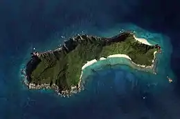 Aerial view of Sukomobanare in 2008 | |
| Geography | |
| Location | East China Sea |
| Coordinates | 28°07′06″N 129°10′07″E |
| Archipelago | Amami Islands |
| Highest elevation | 152 m (499 ft) |
| Administration | |
Japan | |
| Prefectures | Kagoshima Prefecture |
| District | Ōshima District |
| Demographics | |
| Ethnic groups | Ryukyuan, Japanese |
See also
- Desert island
- List of islands
This article is issued from Wikipedia. The text is licensed under Creative Commons - Attribution - Sharealike. Additional terms may apply for the media files.
