Ténès
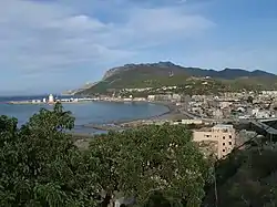
Ténès (Arabic: تنس; Berber: Tinas) is a town in Algeria located around 200 kilometers west of the capital Algiers. As of 2000, it has a population of 35,000 people.
تنس | |
|---|---|
 | |
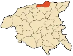 within the Chlef wilaya | |
| Coordinates: 36°30′44″N 1°18′16″E | |
| Country | |
| Province | Chlef Province |
| District | Ténès[1] |
| Area | |
| • Total | 101 km2 (39 sq mi) |
| Elevation | 779 m (2,556 ft) |
| Population (2008[2]) | |
| • Total | 35,459 |
| • Density | 350/km2 (910/sq mi) |
| • Summer (DST) | UTC+1 (CET) |
| |
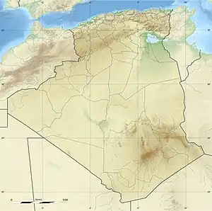 Algeria | |
| |
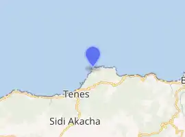
| Location | Cap Ténès Ténès Algeria |
|---|---|
| Coordinates | 36°32′58.87″N 1°20′26.12″E |
| Year first constructed | 1861[3] |
| Foundation | stone base |
| Construction | stone tower |
| Tower shape | quadrangular tower with balcony and lantern |
| Markings / pattern | white lantern, dark green lantern |
| Tower height | 31.50 metres (103.3 ft)[3] |
| Focal height | 94.50 metres (310.0 ft)[3] |
| Light source | mains power |
| Intensity | 1,000 W |
| Range | 29 nautical miles (54 km; 33 mi)[3] |
| Characteristic | Fl (2) W 10s.[4] |
| Admiralty number | E6646 |
| NGA number | 22488 |
| ARLHS number | ALG-018[5] |
| Managing agent | Office Nationale de Signalisation Maritime |
History
Ténès was founded as a Phoenician port[6] in or before the 8th century BC. As with other Phoenician colonies, it fell under the hegemony of Carthage around the 6th century BC and of the Romans after the Punic Wars. Its Punic name was latinized as Cartenna or Cartennae, a plural which suggested the existence of a separate Berber settlement nearby. Ptolemy mentions that the local tribes were known as the "Bakoyta".[7] The city rose to colony status under the empire.[6]
It was sacked by the Vandals during their conquest of Roman North Africa.[6] Reconquered by the Byzantines and then taken by the Umayyad Caliphate, it disappeared except for a mostly ruined fortification.[6]
Medieval Ténès was founded by Spaniards in the 9th century; Al-Bakri dates it to 875 or 876 (262 AH). They established their base 3.2 km (2 mi) from the former settlement. They invited settlers from Elvira and Murcia but many left owing to outbreaks of fever among the new settlers.[6] They were replaced by Berbers from Suk Ibrahim on the Chelif.[6] The city prospered in spite of an unhealthy climate owing to the fertility of the surrounding countryside, which produced fruit and grain in relative abundance.[6]
A local dynasty claiming descent from Ali prospered for a time. They recognized as their overlords the Umayyads, who treated the town as a kind of prison camp for exiles.[6] After the 10th century, it passed in succession under Fatimid, Sanhaja, Maghrawa, Almoravid, Almohad, and Ziyanid control. In the later 15th century, it prospered amid the exodus of Moors from the Spanish Inquisition. The locals overthrew the last of its foreign rulers and established a local sheikh, whose dynasty was eventually compelled to become vassals of Spain.[6]
Ténès was sacked by Oruç Reis in 1517 and conquered for the Ottoman Empire by his brother Hayreddin Barbarossa a few years later.[6] The town was given a garrison but its economic life gradually collapsed, with its European trade in grain gone by the 18th century.[6] It was sacked by Berber revolts and attempted to overthrow Turkish rule on several occasions.[6]
Following the French invasion of Algiers in 1830, Ténès fell under the control of the rebel Abdelkader, who tried to revive its port.[6] The locals finally surrendered to the French without a fight in 1843.[6] Bugeaud then used it as a base to control the Chelif Valley.[6]
Mistaken accounts in the ancient geographers originally caused the French to assume ancient Cartennae had been at Mostaganem, but engravings were soon discovered by archaeologists which established the correct identification.[8] Modern Ténès was established at the ruins of the Phoenician and Roman colony by the French in 1847.[8] Its harbor about 1.5 km distant originally served as a port for goods from the Chelif, but declined following the construction of the Algiers–Oran railway.[8]
Present
At the present time Ténès is a small tourist town with five small hotels, two hospitals, a local museum, a port and a lighthouse. It has some antique sites such as the Phoenician and Roman tombs, the prehistoric caves in Sidi Merouane, the Great Mosque of Sidi Ahmed Boumaza[9] (built some 11 centuries ago), Bab El Bahr, Notre Dame de Ténès, The French cannons, along with many others.
See also
- List of lighthouses in Algeria
- Diocesi di Cartenna on Italian Wikipedia
- Sulaymanid dynasty
References
Citations
- "Décret executif n° 91-306 du 24 août 1991 fixant la liste des communes animées par chaque chef de daïra. 02 - Wilaya de Chlef" [List of municipalities animated by each District chief: 02 - Chlef Province] (PDF) (in French). Journal officiel de la République Algérienne. 4 September 1991. p. 1294. Retrieved 25 October 2019.
- "Wilaya de Chlef : répartition de la population résidente des ménages ordinaires et collectifs, selon la commune de résidence et la dispersion" (PDF) (in French).. Data from the 2008 General Population and Housing Census on the site of the NOS Algeria.
- "Cap Tenes". Office Nationale de Signalisation Maritime. Ministere des Travaux Publics. Retrieved 28 April 2017.
- List of Lights, Pub. 113: The West Coasts of Europe and Africa, the Mediterranean Sea, Black Sea and Azovskoye More (Sea of Azov) (PDF). List of Lights. United States National Geospatial-Intelligence Agency. 2015.
- "Western Algeria". The Lighthouse Directory. University of North Carolina at Chapel Hill. Retrieved 28 April 2017.
- Yver (1927).
- Playfair, Robert Lambert (1891). Handbook for Travellers in Algeria and Tunis. J. Murray. pp. 246–247. Retrieved 18 March 2018.
- Playfair (1874), s.v. "Tenes".
Bibliography
- Playfair, Robert Lambert (1874), A Handbook for Travellers in Algeria, Murray's Handbooks, London: John Murray.
- Yver, G. (1927), "Tenes", The Encyclopedia of Islam..., VIII, Leiden: E.J. Brill, ISBN 9004097961.
.svg.png.webp)