Tét District
Tét (Hungarian: Téti járás) is a district in southern part of Győr-Moson-Sopron County. Tét is also the name of the town where the district seat is found. The district is located in the Western Transdanubia Statistical Region.
Tét District
Téti járás | |
|---|---|
 Coat of arms | |
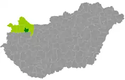 Tét District within Hungary and Győr-Moson-Sopron County. | |
| Country | |
| County | Győr-Moson-Sopron |
| District seat | Tét |
| Area | |
| • Total | 272.62 km2 (105.26 sq mi) |
| Area rank | 7th in Győr-Moson-Sopron |
| Population (2011 census) | |
| • Total | 14,414 |
| • Rank | 7th in Győr-Moson-Sopron |
| • Density | 52/km2 (130/sq mi) |
Geography
Tét District borders with Győr District to the north and east, Pápa District (Veszprém County) to the south, Csorna District to the west. The number of the inhabited places in Tét District is 14.
Municipalities
The district has 1 town and 13 villages. (ordered by population, as of 1 January 2012)[1]
- Árpás (245)
- Csikvánd (454)
- Felpéc (847)
- Gyarmat (1,204)
- Gyömöre (1,254)
- Győrszemere (3,209)
- Kisbabot (205)
- Mérges (75)
- Mórichida (807)
- Rábacsécsény (602)
- Rábaszentmihály (479)
- Rábaszentmiklós (127)
- Szerecseny (776)
- Tét (3,877) – district seat
The bolded municipality is the city.
Demographics
Religion in Tét District (2011 census)
In 2011, it had a population of 14,414 and the population density was 53/km².
| Year | County population[2] | Change |
|---|---|---|
| 2011 | 14,414 | n/a |
Ethnicity
Besides the Hungarian majority, the main minorities are the Roma (approx. 300) and German (100).
Total population (2011 census): 14,414
Ethnic groups (2011 census):[3] Identified themselves: 13,319 persons:
- Hungarians: 12,848 (96.46%)
- Gypsies: 264 (1.98%)
- Others and indefinable: 207 (1.55%)
Approx. 1,000 persons in Tét District did not declare their ethnic group at the 2011 census.
Religion
Religious adherence in the county according to 2011 census:[4]
- Catholic – 7,223 (Roman Catholic – 7,200; Greek Catholic – 19);
- Evangelical – 2,631;
- Reformed – 517;
- other religions – 147;
- Non-religious – 716;
- Atheism – 49;
- Undeclared – 3,131.
See also
References
- A KSH 2012. évi helységnévkönyve
- népesség.com, "Téti járás népessége"
- 4.1.6.1 A népesség nemzetiség szerint, 2011, (in Hungarian)
- 4.1.7.1 A népesség vallás, felekezet szerint, 2011, (in Hungarian)
