Törökszentmiklós
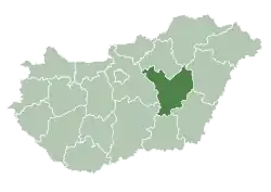
Törökszentmiklós is a town in Jász-Nagykun-Szolnok county, in the Northern Great Plain region of central Hungary. It is the third-largest settlement in the county.
Törökszentmiklós | |
|---|---|
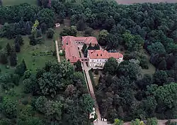 Törökszentmiklós Palace from above | |
 Flag  Coat of arms | |
 Törökszentmiklós | |
| Coordinates: 47°11′N 20°25′E | |
| Country | |
| County | Jász-Nagykun-Szolnok |
| District | Törökszentmiklós |
| Area | |
| • Total | 185.16 km2 (71.49 sq mi) |
| Population (2002) | |
| • Total | 23,145 |
| • Density | 125/km2 (320/sq mi) |
| Time zone | UTC+1 (CET) |
| • Summer (DST) | UTC+2 (CEST) |
| Postal code | 5200 |
| Area code | (+36) 56 |
| Website | www |
Geography
It covers an area of 185.16 km2 (71 sq mi) and has a population of 23,145 people (2002).
History
First time settlement has been mentionaed in the charters of King Zsigmond by the name Zenthmyclos in 1399.
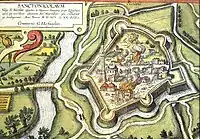
In 1552 the castle of Balaszentmiklós fell under the Turkish siege. In 1685 it was destroyed.
In 1738 the settlement, then known as Török Szent Miklós, became a market town.
Politics
Between 1990s and 2014 local politics has been dominated by Fidesz and Fidesz supporting independent groups, but after 2014 Hungarian local elections, Jobbik became majority party in Municipal Assembly.[1]
The current mayor of Törökszentmiklós is Imre Markót (Our Home Szentmiklós).
The local Municipal Assembly, elected at the 2019 local government elections, is made up of 11 members (1 Mayor, 7 Individual constituencies MEPs and 3 Compensation List MEPs) divided into this political parties and alliances:[2]
| Party | Seats | Current Municipal Assembly | ||||||
|---|---|---|---|---|---|---|---|---|
| Our Home Szentmiklós | 6 | M | ||||||
| Fidesz-KDNP | 5 | |||||||
| Independent | 1 | |||||||
References
- https://static.valasztas.hu/dyn/onk14/szavossz/hu/M11/T073/tjk.html
- "Városi közgyűlés tagjai 2019-2024 - Törökszentmilós (Jász-Nagykun-Szolnok megye)". valasztas.hu. Retrieved 2019-10-29.
External links
| Wikimedia Commons has media related to Törökszentmiklós. |
- Official website in Hungarian
- Törökszentmiklós, Hungary at JewishGen
| Towns (2) |
| |
|---|---|---|
| Villages (5) |
| |
| City with county rights |
|   |
|---|---|---|
| Towns | ||
| Large villages | ||
| Villages |
| |
| Other topics |
| |
| Authority control |
|---|