Týn nad Vltavou
Týn nad Vltavou (Czech pronunciation: [ˈtiːn ˈnad vl̩tavou]; German: Moldautein) is a town in the South Bohemian Region of the Czech Republic. It has about 8,000 inhabitants. The centre of the town is historically significant and is protected by law as Urban monument zone.
Týn nad Vltavou | |
|---|---|
Town | |
.JPG.webp) Týn nad Vltavou | |
 Flag  Coat of arms | |
 Týn nad Vltavou Location in the Czech Republic | |
| Coordinates: 49°13′25″N 14°25′14″E | |
| Country | |
| Region | South Bohemian |
| District | České Budějovice |
| First mentioned | 1229 |
| Government | |
| • Mayor | Ivo Machálek |
| Area | |
| • Total | 43.03 km2 (16.61 sq mi) |
| Elevation | 362 m (1,188 ft) |
| Population (2020-01-01[1]) | |
| • Total | 7,960 |
| • Density | 180/km2 (480/sq mi) |
| Time zone | UTC+1 (CET) |
| • Summer (DST) | UTC+2 (CEST) |
| Postal code | 375 01 |
| Website | www |
Administrative parts
Villages of Hněvkovice na levém břehu Vltavy, Koloděje nad Lužnicí, Netěchovice, Nuzice, Předčice and Vesce are administrative parts of Týn nad Vltavou.
History
Until 1918, Moldauthein – Tyn nad Vltavou was part of the Austrian monarchy (Austria side after the compromise of 1867), in the district with the same name, one of the 94 Bezirkshauptmannschaften in Bohemia.[2]
Sights
Notable people
- Matěj Kopecký (1775–1847), puppeteer
- Alfréd Radok (1914–1976), stage director and film director
Gallery
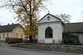 Chapel of Virgin Mary
.JPG.webp) Church of Saint James
Church of Saint James.jpg.webp) Town square
Town square
References
- "Population of Municipalities – 1 January 2020". Czech Statistical Office. 2020-04-30.
- Die postalischen Abstempelungen auf den österreichischen Postwertzeichen-Ausgaben 1867, 1883 und 1890, Wilhelm Klein, 1967
- Energy from Southern Bohemia, Temelin Information Centre publication, 2001
External links
| Wikimedia Commons has media related to Týn nad Vltavou. |
- (in Czech) Official website
| Authority control |
|
|---|
This article is issued from Wikipedia. The text is licensed under Creative Commons - Attribution - Sharealike. Additional terms may apply for the media files.