T2 Road (Zambia)
The T2 is a Trunk Road in Zambia. The road runs from the Tunduma border with Tanzania via Mpika, Kabwe and Lusaka to the Chirundu border with Zimbabwe.[1] The road is the longest route of the country, as it is approximately 1155 kilometers.[2]
| T2 | |
|---|---|
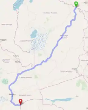 Route of the T2 through Zambia | |
| Route information | |
| Length | 1,155 km (718 mi) |
| Major junctions | |
| North end | Tunduma border with Tanzania |
| M1 in Mpika T3 near Kapiri Mposhi M20 near Chibombo T4/M9 in Lusaka T1 near Kafue M15 near Chirundu | |
| South end | Chirundu border with Zimbabwe |
| Location | |
| Major cities | Mpika, Kabwe, Lusaka, Kafue |
| Highway system | |
| Transport in Zambia | |
For its entire route, the T2 is known as Zambia's Great North Road and is part of the Cape to Cairo Road. Also, the section from Tanzania to Lusaka is known as the Tanzam Highway.
Route
The entire route forms Zambia's Great North Road and is part of the famed Cape to Cairo Road.
Muchinga Province
The T2 Road begins from Zambia's Border Post with Tanzania near Tunduma as the Tanzam Highway. It goes south-west through the town of Nakonde.
From Nakonde, the T2 goes southwards for 86 km to the town of Isoka. After Isoka, the road goes south-west for 263 km, bypassing Chinsali (Muchinga Province's Capital), through Shiwang'andu District, to the town of Mpika, where it is joined by the M1 Road from Kasama and Mbala. The Name Great North Road used to apply to the M1 road up to the Mbala Border with Tanzania, but the name has since been given to the T2 Road to Nakonde, due to its direct route to important Towns in Tanzania.
Central Province
From Mpika, the T2 Road makes a 245 km Journey south-south-west, through Lavushimanda District, crossing into Central Province and passing through Chitambo District, to Serenje. Just before Serenje Town, at a place named Pensulo, the T2 meets a direct road to Luapula Province, named the Serenje-Samfya Road (opened in 1983), which is used by motorists to access Luapula Province quickly.
From Serenje, the T2 makes a 200 km journey west-south-west, bypassing the farming town of Mkushi, to Kapiri Mposhi. From the Tanzania Border Post, the T2 is accompanied to Kapiri Mposhi by a railway named the Tanzania-Zambia Railway (TAZARA Railway).
At Kapiri Mposhi, the T2 Road meets the T3 Road from Ndola and Kitwe in the Copperbelt Province and the Kasumbalesa border with DR Congo. They meet at a T-junction. As the T3 Route ends at this junction, the T2 Route becomes the road southwards towards Kapiri Mposhi Central.
From Kapiri Mposhi, the road goes for 60 km south-south-west to Kabwe, which is Central Province's Capital and home to the Mulungushi Rock of Authority. From Kabwe, the road goes 55 km south-west to the town of Chibombo.
After Chibombo, at the Junction with the M20 Road to Mumbwa (this junction is famously known as Landless Corner), the T2 road turns south-east and quickly enters Chisamba District (bypassing the farming town of Chisamba to the west), before turning directly south towards Lusaka and re-entering Chibombo District (passing through the Katuba Constituency).
Lusaka Province
Next, the T2 leaves Chibombo District, Central Province and enters Lusaka, Zambia's Capital City, in the Province of the same name. It enters just before the National Heroes Stadium. At the roundabout at the northern end of the City Centre, the T2 Route meets the T4 Route (Great East Road) from Chongwe and Chipata (and the Republic of Malawi) and the M9 Road (Great West Road) from Mumbwa and Mongu. This junction of the Great Roads of Zambia marks the end of the T2 being known as the Tanzam Highway.
Right after this roundabout, the T2 becomes Cairo Road, an avenue with many trees and businesses on the road and where heavy vehicles are not permitted to pass. (Trucks are advised to use Lumumba Road to bypass the City Centre to the west and come back on the T2 south of the City Centre)
At the southern end of the City Centre, the T2 has a roundabout again, where it meets Lusaka's Independence Avenue and becomes Kafue Road. At the next junction, the southern end of Lumumba Road is met. This is where heavy vehicles going northwards are advised to join Lumumba Road to skip the town centre and bypass it to the west. (This is also where heavy vehicles going southwards rejoin the main road)
Going south of Lusaka, the road is named Kafue Road. It goes for 45 km, through the town of Chilanga, to the industrial town of Kafue. Just after crossing the Kafue River approximately 15 kilometres after the Kafue Town Centre, the T2 Route temporarily enters Chikankata District in Southern Province, where it meets the north-eastern terminus of the Lusaka–Livingstone road (T1 Route) from Mazabuka, Choma, Livingstone and the Victoria Falls (with links to Botswana, Namibia and north-western Zimbabwe).
From the Livingstone Road (T1) junction, the T2 goes east-south-east, following the Kafue River, to re-enter Lusaka Province and continue through a mountainous area to the town of Chirundu on the border with Zimbabwe (Zambezi River), where there is a bridge (built in 1939) to connect with the A1 Road (R3 Road) on the Zimbabwean side going to Harare. The town on the other side of the border is also named Chirundu.
17 kilometres before Chirundu, the T2 meets the M15 Road, which is the road that provides access to the tourist town of Siavonga on the Zambezi River near Kariba Dam and a border connecting to the town of Kariba on the Zimbabwean side.
As the Cape to Cairo Road, The T2 becomes the Chirundu-Beitbridge Regional Road Corridor in Zimbabwe, which connects to South Africa.
Trans-African Highway Network
The T2 between the Tanzania border and the T1 Road junction south of Kafue is part of the Trans-African Highway 4 (Cairo-Cape Town Highway), which connects Cairo in Egypt with Cape Town in South Africa. (the Cairo-Cape Town Highway continues from here as the T1 Road)
The T2 between Kapiri Mposhi and the Zimbabwe border is part of the Trans-African Highway 9 (Beira-Lobito Highway), which connects Beira in Mozambique with Lobito in Angola. (The Beira-Lobito Highway continues from Kapiri Mposhi as the T3 Road)[3]
Great North Road
In the past, the M1 Road from Mpika northwards to Mbala and Mpulungu was known as Zambia's Great North Road. Then, the name Great North Road was given to the T2 Road from Mpika north-east to the Tanzania Border just after Nakonde, probably due to the fact that it is part of the Cape to Cairo Road. So, the M1 Road is now known as the Old Great North Road.
Before 1939, the T1 Road from its junction with the T2 Road near Kafue south-west to Livingstone and the Victoria Falls was known as the Great North Road. Then, in 1939, when the Chirundu Bridge over the Zambezi River was opened to connect the T2 Road with the A1 Road in Zimbabwe to Harare, the T2 from its junction with the T1 eastwards to Chirundu became known as the Great North Road, probably because the route to Harare was officially declared part of the Cape to Cairo Road rather than the route to Livingstone.
Therefore, the T2 Road now forms the entire section of Zambia's Great North Road.
M15 Road (Zambia)
The M15 Road is the 65-kilometre road connecting the tourist town of Siavonga in Southern Province with Chirundu in Lusaka Province.[1] Together with the T2 Road, it is the main route connecting Siavonga with the rest of the country.
It begins 18 kilometres west of Chirundu in Lusaka Province at a junction with the T2 Road and goes southwards for 65 kilometres to Siavonga in Southern Province. It bypasses Siavonga town centre to the east and becomes the eastern wall of the Kariba Dam, where it crosses the Zambezi River borderline into the republic of Zimbabwe, with the town of Kariba on the Zimbabwean side.
References
- "Roads and Road Traffic (Amendment) Act, Cap 464 | Zambia Legal Information Institute". zambialii.org. Retrieved 2019-07-03.
- https://citymeter.net/distance-between-Nakonde-and-Chirundu-via-Lusaka-535117992&ved=2ahUKEwjp9ZeYnILfAhUMLcAKHR4DD5oQFjACegQICBAB&usg=AOvVaw363FbczGO4mADvLKWxiRXH
- nl:T2 (Zambia)