Taiping Mountain Forest Railway
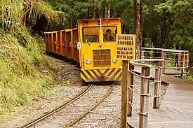
Taiping Mountain Forest Railway (Chinese: 太平山森林鐵路; Pe̍h-ōe-jī: Thài-pîng-soaⁿ Sim-lîm Thih-lō͘), also known as Bongbong Train (Chinese: 蹦蹦車; Pe̍h-ōe-jī: Póng-póng-chhia) is a 36.4 km (22.6 miles) long narrow-gauge forest railway with a gauge of 2 ft 6 in (762 mm) in Yilan County, Taiwan.[1] Part of it can be used for heritage trains, but it is temporarily closed.[2]
| Taiping Mountain Forest Railway | |||||||||||||||||||||||||||||||||||||||||||||||||||||||||||||||||||||||||||||||
|---|---|---|---|---|---|---|---|---|---|---|---|---|---|---|---|---|---|---|---|---|---|---|---|---|---|---|---|---|---|---|---|---|---|---|---|---|---|---|---|---|---|---|---|---|---|---|---|---|---|---|---|---|---|---|---|---|---|---|---|---|---|---|---|---|---|---|---|---|---|---|---|---|---|---|---|---|---|---|---|
 Taipingshan Mountain Forest Railway
 | |||||||||||||||||||||||||||||||||||||||||||||||||||||||||||||||||||||||||||||||
| Technical | |||||||||||||||||||||||||||||||||||||||||||||||||||||||||||||||||||||||||||||||
| Line length | 36.4 km (22.6 miles) | ||||||||||||||||||||||||||||||||||||||||||||||||||||||||||||||||||||||||||||||
| Track gauge | 2 ft 6 in (762 mm) | ||||||||||||||||||||||||||||||||||||||||||||||||||||||||||||||||||||||||||||||
| Minimum radius | 15 m | ||||||||||||||||||||||||||||||||||||||||||||||||||||||||||||||||||||||||||||||
| Operating speed | 15 km/h max. | ||||||||||||||||||||||||||||||||||||||||||||||||||||||||||||||||||||||||||||||
| Maximum incline | 3 % | ||||||||||||||||||||||||||||||||||||||||||||||||||||||||||||||||||||||||||||||
| |||||||||||||||||||||||||||||||||||||||||||||||||||||||||||||||||||||||||||||||
History
The Taiping Mountain Forest Railway was commissioned in 1920 and connected to the Luodong Forest Railway in 1924. No regular passenger services have been provided since 1979, but a short section of the track was used for a sightseeing train. Since commercial forestry has been phased out on Taiping Mountain, the area is used for sightseeing and recreation.[3]
In 2012, due to damage caused by a typhoon, the sightseeing train was taken out of use. On 19 September 2018, the operation was officially resumed on a 3 km-long section of the track. Eight trips per day are available between Tài Píng Shān-sho station and Shigeru station at intervals of 30 minutes. Each one-way trip takes 20 minutes.[4]
Maosing Reminiscent Trail
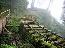
The 1.5 km (nearly 1 mile)-long Maosing Reminiscent Trail (茂興懷舊步道, closed) starts at the platform of Maosing Railway Station. It runs at a height of 1.870 m to 1.950 m above sea level on the disused railway track, and has thus only a relatively small gradient. There are state-of-the-art facilities providing recreation and information boards about history, natural resources, and geology.[5]
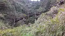
The Maosing Reminiscent Trail provides a combination of both heritage and riskless ecotourism. Most of the railway sleepers are rotten, but a majority of the rails are still in good order; the rails are left in place and the railway sleepers covered in gravel to provide an attractive footpath. The bulk of the trestle bridges has collapsed or deteriorated. Thus, some of them have been repaired, some of them left as historic ruins, and others have had to be removed and replaced by modern suspension bridges. The Maosing Reminiscent Trail is consequently a safe and comfortable footpath, while it takes care of the environment and the preservation of the historic trestle bridges.[5]
Jancing Historic Trail
The Jancing Historic Trail (見晴懷古步道)[6] was installed on a section of the former Jancing Forest Railway and originally had a total length of 2.35 km (1.4 miles). Since a landslide occurred, only 0.9 km (0.5 miles) are publicly accessible. The former Jancing Forest Railway was approximately 5.5 km (3.4 miles) long and provides access to the natural and cultural heritage along the old railway track. The remaining rails, trolleys, and bogies are a reminder of long-gone times of the lumber industry.[7]
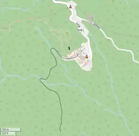
Photos


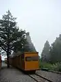
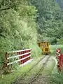
Track
Old Taiping Mountain Railway
The Old Taiping Mountain Railway (Chinese: 舊太平山; Pe̍h-ōe-jī: Kū Thài-pîng-soaⁿ) has been removed and only very little information about it is available.
New Taiping Mountain Railway
The New Taiping Mountain Railway (Chinese: 新太平山; Pe̍h-ōe-jī: Sin Thài-pîng-soaⁿ) is the main system that exists today. It uses a combination of railways and aerial tramways to transport lumber down the mountainous terrain.
Stations
| Type | Track | Station | Chinese | Taiwanese | Hakka | Transfers and Notes |
|---|---|---|---|---|---|---|
| Railway | Jên-tsê Line | T’u-ch’ang | 土場 | Thô͘-tiûⁿ | Thú-chhòng | → |
| Jên-tsê | 仁澤 | Jîn-te̍k | Yìn-chet | |||
| Aerial tramway | Jên-tsê Tramway | |||||
| Middle | 中間 | Tiong-kan | Chûng-kiên | |||
| Railway | Lan-t’ai Line | |||||
| Lan-t’ai | 蘭臺 | Lân-tâi | Làn-thòi | |||
| Aerial tramway | Pai-ling Tramway | |||||
| Pai-ling | 白嶺 | Pe̍h-niá | Pha̍k-liâng | |||
| Railway | Pai-mi Line | |||||
| Pai-mi | 白糸 | Pe̍h-mi | Pha̍k-mì | |||
| Aerial tramway | Pai-mi Tramway | |||||
| Shang-p’ing | 上平 | Siōng-pîng | Sông-phìn | |||
| Railway | T’ai-p’ing Mt Line | |||||
| T’ai-p’ing Mt | 太平山 | Thài-pîng-soaⁿ | Thai-phìn-sân | |||
| T’ai-p’ing Mt Junction | 太平山分歧點 | Thài-pîng-soaⁿ Hun-kî-tiám | Thai-phìn-sân Fûn-khîa-tiám |
Junction of San-hsing, Mao-hsing, and Chien-ch’ing Lines | ||
| Railway | Chien-ch’ing Line | Rail End | 路尾 | Lō͘-bóe | Lu-mî | Border of Taiping Mt and Dayuan Mt Work Stations |
| Mao-hsing Line | Mao-hsing | 茂興 | Bō͘-heng | Meu-hîn | Limited tourist service around station | |
Lines
| Name of the track | From station to station | Distance | Max. incline | Min. radius | Bridges (total length) |
Tunnels (total length) |
Number of trains |
| Renze (仁澤線) |
Tuchang (土場) - Renze (仁澤) | 4,53 km | 3% | 15 m | 63(1665 m) | 2(62 m) | 3 |
| Lantai (蘭臺線) |
Middle Station (中間) - Lantai (蘭臺) | 3,92 km | 2% | 15 m | 62(1635 m) | 1(47 m) | 3 |
| Baimi (白糸線) |
Bailing (白嶺) - Baimi (白糸) | 3,20 km | 2,5% | 15 m | 16(480 m) | 0(0 m) | 3 |
| Taipingshan (太平山線) |
Shangping (上平) - Taipingshan (太平山) | 1,60 km | 2,5% | 15 m | 16(480 m) | 0(0 m) | 4 |
| Sanxing (三星線) |
Taiping Mountain Junction (太平山分歧點) - Terminus | 15,3 km | 2,5% | 15 m | 16(480 m) | 0(0 m) | 4 |
| Maoxing (Maosing) (茂興線) |
Taiping Mountain Junction - Terminus | 20,9 km | 2,5% | 42 | 0(0 m) | 3 | |
| Jianqing (Jiancing) (見晴線) |
Taiping Mountain Junction - Endstation | 5,60 km | 2% | 15 m | 62(1635 m) | 0(0 m) |
Dayuan Mountain Railway
Dayuan Mountain (Chinese: 大元山; Pe̍h-ōe-jī: Tāi-goân-soaⁿ)
| Name of the track | From station to station | Distance | Max. incline | Min. radius | Bridges (total length) |
Tunnels (total length) |
Number of trains |
| Dayuanshan (大元山線) / Si gongli (四公里線) | Anbu aerial tram (鞍部索道), Dayuan aerial tram (大元索道) - Cuifeng aerial tram (翠峰索道) | 7,86 km | 6,3% | 20 m | 88(570 m) | 1 | |
| Cuifeng (翠峰線) | Cuifeng aerial tram (翠峰索道) - Wangyang mountain side (望洋山腰) | 9,0 km | 2,5% | 97(570 m) | 0 | ||
| Qingfeng (晴峰線) | Qingfeng aerial tram (晴峰索道) - Zhongxinggang (中興崗) | 5,1 km | 2,0% | 25 | 0 | ||
| Piya (埤ㄚ線) | Start of Piya aerial tram (埤ㄚ索道著點) |
References
- Robert Kelly und Chung Wah Chow: Lonely Planet Taiwan. Lonely Planet, 1 February 2014. Abgerufen am 25. November 2017.
- Bong Bong Train (temporarily closed).
- 行政院農委會林務局©版權所有 (Executive Yuan COA Forest Service): 太平山森林鐵路 (Taiping Mountain Forest Railway). Archived 1 December 2017 at the Wayback Machine Retrieved 25 November 2017. (Chinese)
- Radio Taiwan International: 宜蘭太平山のトロッコ、19日に運行再開.
- Maosing Reminiscent Trail. 27 June 2016. Accessed 25 November 2017.
- Jancing-Geschichtslehrpfad auf Google Streetview.
- Jancing Historic Trail. 30 October 2017.
| Wikimedia Commons has media related to Taiping Mountain Forest Railway. |