Tammany Trace
The Tammany Trace is a rail trail in Louisiana occupying a former Illinois Central Railroad corridor.
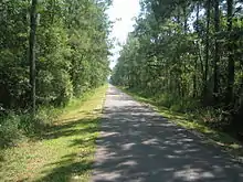
Tammany Trace near Mandeville
It has been developed into a 31-mile (50 km) asphalt trail for hiking, cycling, and wheelchair use. Some parts of the Trace include a separate equestrian pathway suitable for horse riding.[1]
It connects Covington, Abita Springs, Mandeville, Lacombe, and Slidell running along the northshore of Lake Pontchartrain. The trail was damaged by Hurricane Katrina, but was reopened by early 2007. The Trace is easily accessible from Fontainebleau State Park.
Location
| Point | Coordinates |
|---|---|
| West end of the trail | 30.477°N 90.094°W |
| 59 trailhead/caboose | 30.417°N 90.044°W |
| Lafitte Gerard trailhead | 30.363°N 90.062°W |
| Lacombe trailhead | 30.309°N 89.930°W |
| Slidell/Carollo trailhead | 30.301°N 89.833°W |
| East end of the trail | 30.297°N 89.780°W |
See also
This article is issued from Wikipedia. The text is licensed under Creative Commons - Attribution - Sharealike. Additional terms may apply for the media files.
