Tangimoana
Tangimoana is a community in the Manawatū-Whanganui Region of the North Island of New Zealand. It had a population of 198 permanent residents in 2013. It is located 15 kilometres southwest of Bulls, and 30 kilometres west of Palmerston North.
Tangimoana | |
|---|---|
 Tangimoana | |
| Coordinates: 40°18′S 175°15′E | |
| Country | New Zealand |
| Region | Manawatū-Whanganui |
| District | Manawatu District |
| Population (2013) | |
| • Total | 198 |
| Postcode(s) | 4822 |
The New Zealand Ministry for Culture and Heritage gives a translation of "weeping sea" for Tangimoana.[1]
The settlement lies on the southern bank of the Rangitīkei River near the mouth. It was developed in 1920 as a holiday place for people from Palmerston North and other inland towns and sections sold from 1921.[2]
The Boating Club has a licensed facility for members and their guests. A small corner store is open daily, it sells basic supplies as well as takeaway food.
Tangimoana is well known for its laid back attitude and is popular with those seeking an alternative lifestyle. Many residents are artists and once a year they hold an Art Festival to showcase their works.
Tangimoana has limited facilities and very few employment opportunities. Most residents travel to Palmerston North, Feilding or Levin for employment. The main attraction is the river and beach which are both peaceful and natural. It is a popular beach for horses and dogs. A four-wheel drive vehicle is needed to drive directly to the ocean.
Demographics
Tangimoana had a population of 198 at the 2013 New Zealand census, a decrease of 36 people since the 2006 census. There were 96 males and 102 females.[3] 88.9% were European/Pākehā, 12.7% were Māori, 0.0% were Pacific peoples and 0.0% were Asian.[4]
Education
Tangimoana School is a coeducational full primary (years 1-8) school[5] with a roll of 21 as of March 2020.[6]
A bus service takes secondary school students into Palmerston North on weekdays. The Carnarvon bus was extended to Tangimoana in 1924.[7]
SIGINT facility
The New Zealand Government Communications Security Bureau operates what it describes as a radio communications interception facility in the area; it is generally believed to be a signals intelligence, or SIGINT facility operating under umbrella of the ECHELON espionage network, under the auspices the UKUSA consortium of intelligent agencies.
Flooding
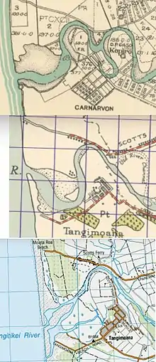
Tangimoana was among the most seriously affected communities in the 2004 flooding.[8] Other notable floods were in 1882,[9] 1897,[10] 1917,[11] 1936,[12] 1958 and 1965.[2] In 1944[13] and 1967 cuttings were made to divert the river away from the village, and stopbanks were built[2] and extended in 2010.[8] The cuttings to shorten the river can be seen on the maps from 1928 to 2018.
Tawhirihoe Scientific Reserve
A Department of Conservation reserve aims to conserve remnants of the dune and wetland ecosystems in the estuary.[14] Plants include the Nationally Critical dune plant, Pimelea actea.[15] Despite attempts to keep motor vehicles off the dunes,[16] damage is still being done.[15]
External links
- Tangimoana settlement and history
- Aerial view of Defence Communications Unit
- Secret Power - New Zealand's Role in the International Spy Network
- Secret Power, New Zealand's Role in the International Spy Network; Craig Potton Publishing, Nelson, NZ; ISBN 0-908802-35-8; 1996 (ONLINE EDITION)
References
- "1000 Māori place names". New Zealand Ministry for Culture and Heritage. 6 August 2019.
- "Manawatu District Council Coastal Reserves Management Plan" (PDF). 2007.
- 2013 Census QuickStats about a place : Tangimoana
- 2013 Census QuickStats about a place (Cultural diversity) : Tangimoana
- Education Counts: Tangimoana School
- "New Zealand Schools Directory". New Zealand Ministry of Education. Retrieved 26 April 2020.
- "MANAWATU STANDARD". paperspast.natlib.govt.nz. 20 December 1924. Retrieved 19 September 2020.
- "Tangimoana flood response put to test". www.scoop.co.nz. 11 May 2015. Retrieved 19 September 2020.
- "DESTRUCTIVE FLOOD IN THE RANGITIKEI RIVER. COLONIST". paperspast.natlib.govt.nz. 16 June 1882. Retrieved 19 September 2020.
- "Floods in the Rangitikei. MANAWATU HERALD". paperspast.natlib.govt.nz. 4 February 1897. Retrieved 19 September 2020.
- "RANGITIKEI RIVER IN FLOOD. WANGANUI CHRONICLE". paperspast.natlib.govt.nz. 10 July 1917. Retrieved 19 September 2020.
- "MANAWATU RIVER IN FLOOD. MANAWATU HERALD". paperspast.natlib.govt.nz. 27 February 1936. Retrieved 19 September 2020.
- "FLOOD CONTROL WORKS. MANAWATU STANDARD". paperspast.natlib.govt.nz. 27 October 1944. Retrieved 19 September 2020.
- "Super Sites for Education in Rangitikei - Manawatu - Tawhirihoe Scientific Reserve" (PDF). DoC.
- "Wellington Botanical Society Trip Report - Rangitikei and Foxton areas, Manawatu". www.wellingtonbotsoc.org.nz. Retrieved 19 September 2020.
- "Reserve protection a priority". Stuff. 26 January 2010. Retrieved 19 September 2020.