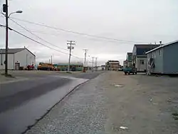
Tasiujaq
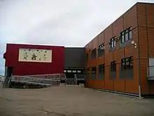
Tasiujaq (Inuktitut: ᑕᓯᐅᔭᖅ, meaning: Which resembles a lake[4]) is a northern village (Inuit community) in Nunavik, in northern Quebec, Canada. Its population in the Canada 2011 Census was 303.
Tasiujaq
ᑕᓯᐅᔭᖅ | |
|---|---|
 | |
 Tasiujaq | |
| Coordinates: 58°42′N 69°56′W[1] | |
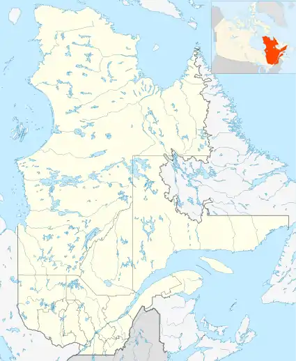
| Country | Canada |
| Province | Quebec |
| Region | Nord-du-Québec |
| TE | Kativik |
| Constituted | February 2, 1980 |
| Government | |
| • Mayor | Billy Cain |
| • Federal riding | Abitibi—Baie-James—Nunavik—Eeyou |
| • Prov. riding | Ungava |
| Area | |
| • Total | 67.30 km2 (25.98 sq mi) |
| • Land | 66.54 km2 (25.69 sq mi) |
| Population (2011)[3] | |
| • Total | 303 |
| • Density | 4.6/km2 (12/sq mi) |
| • Change (2006–11) | |
| • Dwellings | 72 |
| Time zone | UTC−5 (EST) |
| • Summer (DST) | UTC−4 (EDT) |
| Postal code(s) | J0M 1T0 |
| Area code(s) | 819 |
| Website | www |
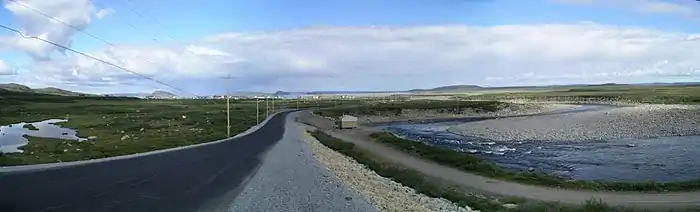
It was built on the shores of Leaf Lake at the head of Deep Harbour and lies a few kilometres north of the tree line, where the shrub tundra finally gives way to the arctic tundra. Tasiujaq actually refers to the whole of Leaf Basin: Leaf Lake, Leaf Passage and Leaf Bay. Leaf Basin is renowned for its high tides, which regularly exceed 15 metres.
The bedrock under Tasiujaq consists of sedimentary and metamorphic formations, chiefly sandstone, slate, greywacke and argillite. Iron ore, dolomite, and mafic rocks are nearby.[5]
The region is very rich in marine mammals (seal and beluga), fish (Arctic char, Atlantic salmon, trout), ducks (particularly eider ducks) and many seabirds; also, close to 1000 musk-ox roam the surrounding area. Gyrfalcons and peregrine falcons are commonly found nesting on the islands of Leaf Basin and surrounding cliffs.
The French fur company Révillon Frères and the Hudson's Bay Company each opened trading posts in 1905 and 1907, respectively, on a site located east of today's settlement. This settlement was along a traditional dogsled route used by Inuit to travel between Kuujjuaq and Kangirsuk. However, both posts had been closed by 1935 without any village ever having developed around them.
In the 1950s, when the federal government opened a school in Kuujjuaq and started delivering social services, many Inuit congregated around the emerging village. The wildlife resources of Kuujjuaq, however, were scarce and many Inuit were forced to rely on governmental financial aid. In 1963, the Northern Quebec directorate of the provincial government, hoping to remedy in part this problem, decided to create a new village on the south shore of Leaf Lake where wildlife resources were more plentiful.
In 1966, with the project about to start, the Inuit families which would relocate were divided as to where their future village should be built. A choice had to be made between a site known as Qaamanialuk Paanga and the site of the old trading posts. Qaamanialuk Paanga was finally selected because it was easily accessible by boats used for summer hunting and fishing, nearby Finger River provided the necessary drinking water, and there was room to construct a landing strip. The new village was subsequently given the name Tasiujaq. The main reason the old trading post site was not selected as the site for the new village was its foreshore (tide land) was dotted with large boulders, and access by boat in summer would have been difficult. In 1971, once the community was organized, a cooperative store was established independently by residents, and is now associated with the Federation of Co-operatives of Northern Quebec. Since 1996, the police services, as the other villages in the Kativik region, are provided by the Kativik Regional Police Force (KRPF).[6]
Tasiujaq has low tide harbour five kilometres north of the village, on Rowe Island.[7] The Tasiujaq Airport is located few kilometres south of the village. Tasiujaq is the final destination for the canoeists paddling down Leaf River.[7][8][9]
References
- Reference number 97010 of the Commission de toponymie du Québec (in French)
- Geographic code 99100 in the official Répertoire des municipalités (in French)
- "(Code 2499100) Census Profile". 2011 census. Statistics Canada. 2012.
- Nunavik Tourism Association & Tourisme Quebec: Nunavik Official Tourist Guide 2007-2008, page 52
- https://geoscan.nrcan.gc.ca/starweb/geoscan/servlet.starweb?path=geoscan/downloade.web&search1=R=100600 Gross, G.A. Iron deposits near Ungava Bay, Quebec. Geological Survey of Canada, Bulletin 82, 1962
- KRPF. "General Information". Home. Retrieved 2017-07-03.
- Lester Kovac: Charpentier/Lear 2007
- Tim Kunin: Leaf River Trip, August 1998 Archived 2010-12-12 at the Wayback Machine
- Willem Lange: Leaf River, Northern Quebec 2001 Archived 2010-12-12 at the Wayback Machine
- "Our Schools." Kativik School Board. Retrieved on September 23, 2017.
External links
| Wikimedia Commons has media related to Tasiujaq. |
