Te Rahu
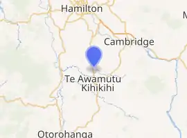
Te Rahu is a rural locality in the Waipa District and Waikato region of New Zealand's North Island.
Te Rahu | |
|---|---|
Village | |
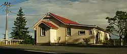 Te Rahu Hall | |
| |
| Coordinates: 37.978°S 175.327°E | |
| Country | New Zealand |
| Region | Waikato Region |
| District | Waipa District |
| Population (2018 census) | |
| • Territorial | 1,167 |
| Time zone | UTC+12 (NZST) |
| • Summer (DST) | UTC+13 (NZDT) |
It is located south of Ōhaupō and north of Te Awamutu, on State Highway 3.
Lake Ngaroto is northwest of the locality.
History
The Battle of Hingakākā was fought west of Te Rahu in the late 18th or early 19th centuries.[1]
Te Rahu was established after the Invasion of the Waikato of 1863–64,[2] and described as a thriving village in 1867.[3]
A school was operating by 1878[2][4] and continued until at least 1939[5] but was gone by 1943.[6]
Te Rahu Hall was built around 1905, and replaced or renovated in 1927.[2][7]
Demographics
| Year | Pop. | ±% p.a. |
|---|---|---|
| 2006 | 906 | — |
| 2013 | 978 | +1.10% |
| 2018 | 1,167 | +3.60% |
| Source: [8] | ||
The statistical area of Te Rahu, which at 55 square kilometres is larger than the community, had a population of 1,167 at the 2018 New Zealand census, an increase of 189 people (19.3%) since the 2013 census, and an increase of 261 people (28.8%) since the 2006 census. There were 411 households. There were 609 males and 558 females, giving a sex ratio of 1.09 males per female. The median age was 39.8 years (compared with 37.4 years nationally), with 240 people (20.6%) aged under 15 years, 195 (16.7%) aged 15 to 29, 561 (48.1%) aged 30 to 64, and 171 (14.7%) aged 65 or older.
Ethnicities were 91.0% European/Pākehā, 11.1% Māori, 0.5% Pacific peoples, 5.7% Asian, and 1.8% other ethnicities (totals add to more than 100% since people could identify with multiple ethnicities).
The proportion of people born overseas was 14.9%, compared with 27.1% nationally.
Although some people objected to giving their religion, 50.9% had no religion, 39.1% were Christian, 0.3% were Hindu, 0.0% were Muslim, 0.5% were Buddhist and 3.1% had other religions.
Of those at least 15 years old, 180 (19.4%) people had a bachelor or higher degree, and 177 (19.1%) people had no formal qualifications. The median income was $44,200, compared with $31,800 nationally. The employment status of those at least 15 was that 528 (57.0%) people were employed full-time, 147 (15.9%) were part-time, and 18 (1.9%) were unemployed.[8]
References
- The Oxford companion to New Zealand military history, p. 653.
- McEwan, Ann (27 January 2017). "Memory box". Waikato Times.
- "Farm at Te Awamutu – Cream of the Waikato". Daily Southern Cross. 22 April 1867. p. 2.
- "Anent Mr Maclaurin's Case!". Waikato Times. 23 July 1878. p. 3.
- "Summer Show – Te Awamutu Display". New Zealand Herald. 14 February 1939. p. 16.
- "Tenders for Removal of Macrocarpa Trees from Te Rahu School Site". New Zealand Herald. 19 August 1943. p. 2.
- "Progress of Te Rahu". New Zealand Herald. 24 August 1927. p. 15.
- "Statistical area 1 dataset for 2018 Census". Statistics New Zealand. March 2020. Te Rahu (182200). 2018 Census place summary: Te Rahu