Texas State Highway 255
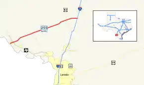
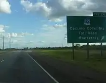
State Highway 255 (SH 255) is a Texas state highway that allows international traffic to bypass Laredo. Located in Webb County, the highway provides a connection between the Colombia Solidarity International Bridge to Interstate 35 at exit #24.[1] The route opened in 2000 as the Camino Colombia Toll Road, and was one of the few operating toll roads in the United States to have gone through the legal process of foreclosure. The toll designation was removed from the route in 2017.[2]
| ||||
|---|---|---|---|---|
 | ||||
| Route information | ||||
| Maintained by TxDOT | ||||
| Length | 22.451 mi[1] (36.131 km) | |||
| Existed | 2004–present | |||
| Major junctions | ||||
| West end | Colombia Solidarity International Bridge at the International Border | |||
| East end | ||||
| Location | ||||
| Counties | Webb | |||
| Highway system | ||||
| ||||


Route description
SH 255 begins at the Colombia Solidarity International Bridge on the United States–Mexico border. SH 255 heads northeast from there as a 4-lane divided highway, crosses FM 1472 (Mines Road), then merges down to a 2-lane road just west of the former toll barrier. SH 255 continues northeast to an intersection at FM 3338 and a diamond interchange with US 83. It continues to the northeast to its eastern terminus at I-35.[3] Although the portion from the United States–Mexico border to FM 1472 is officially an extension of SH 255, it is still signed in the field as FM 255.
Beginning June 1, 2009, the use of the TxTag electronic toll collection system (or the interoperable EZ TAG and TollTag system) was mandatory; unlike other TxDOT-operated toll roads, there was no pay-by-mail option, although the option to set up a prepaid day pass account was provided. Motorists were also able to use Laredo Trade Tags if they were connected to a TxTag account.[4]
History
The route was originally approved in 1997 as a privately owned toll route for mainly truck traffic to bypass the city of Laredo for traffic congestion. The route was opened as the Camino Colombia Toll Road in October 2000, at a cost of approximately $90 million. SH 255 inherited its number from FM 255, which was designated on the route between the border crossing and FM 1472 on November 30, 1989.[5] The SH 255 designation was extended over this segment on June 30, 2005.[1]
In August 2001, landowners that were shareholders of the route filed a lawsuit, claiming that profits and traffic usage were less than expected. The failure of the route was attributed to the price for truck traffic ($16), the continuation of U.S. government policies banning Mexican trucks from the interior of the United States (which had been expected to be abolished under the North American Free Trade Agreement), and the approval of a new freeway connecting route from the World Trade International Bridge crossing along Loop 20 to Interstate 35.
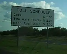
The toll road was foreclosed on late in 2003, and was auctioned off on the steps of the Webb County courthouse January 6, 2004.[6] It was purchased by its main creditor, the John Hancock Life Insurance Company, for the minimum $12 million, 1/6 of the construction value. The only other bidder was the Texas Department of Transportation at $11 million. The route was subsequently closed to all traffic. On May 27, 2004, TxDOT purchased the route from John Hancock for a negotiated $20 million, and reopened the route in September, dropping the toll to $2 toll for cars and $2 per additional axle.[7]
During the 2017 Texas legislative session, language was added to Senate Bill 312 that disallowed TxDOT from continuing to operate the route as a toll project.[8] The bill was passed by both the Texas Senate and Texas House of Representatives on May 30, 2017, was signed by the governor on June 9, 2017, and took effect September 1, 2017.[2]
Major intersections
The entire route is in Webb County.
| Location | mi[10] | km | Destinations | Notes | |
|---|---|---|---|---|---|
| Rio Grande | 0.0 | 0.0 | Colombia Solidarity International Bridge – Mexico Border | Western terminus; continues as Nuevo Leon State Highway Spur 1 | |
| Laredo | 0.2 | 0.32 | Laredo Colombia Solidarity Port of Entry | ||
| 1.3 | 2.1 | At-grade intersection | |||
| 1.9 | 3.1 | Las Minas Boulevard | At-grade intersection | ||
| | 3.7 | 6.0 | Port Industrial Boulevard | At-grade intersection | |
| | 4.7 | 7.6 | CCTR Admin Building | ||
| | 8.2 | 13.2 | At-grade intersection, north end of FM 3338 | ||
| | 8.7 | 14.0 | Camino Colombia Automated Gantry (18' clearance, no longer tolled as of September 1, 2017[2]) | ||
| | 17.9 | 28.8 | Jefferies Road | At-grade intersection | |
| | 19.3 | 31.1 | Interchange | ||
| | 22.7 | 36.5 | Eastern terminus, interchange with I-35 exit 24 | ||
1.000 mi = 1.609 km; 1.000 km = 0.621 mi
| |||||
References
- Transportation Planning and Programming Division (n.d.). "State Highway No. 255". Highway Designation Files. Texas Department of Transportation. Retrieved 2008-03-13.
- "TxDOT legislation converts Camino Colombia into a non-toll road". LMTonline. 2017-08-25. Retrieved 2018-01-24.
- Google (2008-03-14). "overview map of SH 255" (Map). Google Maps. Google. Retrieved 2008-03-14.
- "Archived copy". Archived from the original on 2009-06-08. Retrieved 2013-09-29.CS1 maint: archived copy as title (link)
- Transportation Planning and Programming Division (n.d.). "Farm to Market Road No. 255". Highway Designation Files. Texas Department of Transportation. Retrieved 2011-10-03.
- "Camino Colombia TR in creditor hands, fate uncertain". TOLLROADSnews. 2004-01-15. Archived from the original on September 28, 2007. Retrieved 2008-03-14.
- "Camino Colombia TR begins operations under TXDOT". TOLLROADSnews. 2004-09-09. Retrieved 2008-03-14.
- Section 228.201(d)
- Transportation Planning and Programming Division (n.d.). "Farm to Market Road No. 46". Highway Designation Files. Texas Department of Transportation. Retrieved 2011-09-02.
- Google (September 29, 2013). "SH 255" (Map). Google Maps. Google. Retrieved September 29, 2013.
