Texas State Highway 322
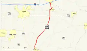
State Highway 322 (SH 322) is a Texas state highway that runs from Henderson north to Interstate 20 near Longview. This route was designated on October 30, 1939 from Henderson to the Rusk/Gregg County Line. On February 11, 1944, SH 322 was extended north to SH 149. On September 14, 1944, SH 322 was extended to the traffic circle northeast of Henderson. On June 1, 1967, SH 322 was extended northward to I-20.
| ||||
|---|---|---|---|---|
 | ||||
| Route information | ||||
| Maintained by TxDOT | ||||
| Length | 18.0 mi[1] (29.0 km) | |||
| Existed | 1939–present | |||
| Major junctions | ||||
| South end | ||||
| North end | ||||
| Location | ||||
| Counties | Rusk, Gregg | |||
| Highway system | ||||
| ||||
Route description

SH 322 begins at a junction with US 259 in Henderson. It heads northeast from this junction to an intersection with FM 850. The highway continues to the northeast to an intersection with FM 1249. Heading towards the north, the highway continues to a junction with FM 2011. The highway continues to the north to an intersection with FM 2204. It continues to the north to a junction with FM 349 in Lakeport. As the highway continues to the northeast, it intersects SH 149 in Lakeport. SH 320 and SH 149 begin to run concurrently to the north until they split in Longview. SH 322 reaches its northern terminus at I-20 in Longview. The roadway continues to the north as Loop 281.[2]
Major intersections
| County | Location | mi | km | Destinations | Notes |
|---|---|---|---|---|---|
| Rusk | Henderson | ||||
| | |||||
| | |||||
| Gregg | | ||||
| | |||||
| | |||||
| Lakeport | South end of SH 149 overlap | ||||
| Longview | North end of SH 149 overlap | ||||
| Interchange | |||||
| 1.000 mi = 1.609 km; 1.000 km = 0.621 mi | |||||
References
- Transportation Planning and Programming Division (n.d.). "State Highway No. 322". Highway Designation Files. Texas Department of Transportation. Retrieved 2010-11-01.
- Google (2008-03-21). "overview map of SH 322" (Map). Google Maps. Google. Retrieved 2008-03-21.
