Texas State Highway 47
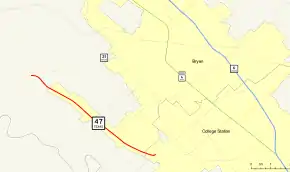
State Highway 47 (SH 47) runs from FM 60 near Easterwood Airport and Texas A&M University Research Park in College Station to SH 21 at Texas A&M University-Riverside near Bryan. This highway was designated on January 28, 1987.
| ||||
|---|---|---|---|---|
| Riverside Parkway | ||||
 | ||||
| Route information | ||||
| Maintained by TxDOT | ||||
| Length | 7.146 mi[1] (11.500 km) | |||
| Existed | 1987–present | |||
| Major junctions | ||||
| South end | ||||
| North end | ||||
| Location | ||||
| Counties | Brazos | |||
| Highway system | ||||
| ||||
Previous routes

SH 47 was originally planned on August 21, 1923, along a previous section of SH 1A and SH 1C from near the intersection of the Texas, Arkansas, and Louisiana state borders, northwest through Atlanta, then northeast through Texarkana to the Arkansas border north of Texarkana.[2] On June 24, 1931, the highway was rerouted west from Atlanta to Daingerfield, replacing SH 48, while the old route southeast of Atlanta became part of SH 77[3] On April 19, 1938, SH 47 Bypass was designated from SH 47 to SH 1.[4] SH 47 Bypass extended north to SH 5 on October 24, 1938.[5] On September 26, 1939, this classification was canceled when the route was transferred to SH 11. SH 47 Bypass became Loop 14.
Junction list
The entire route is in Brazos County. All exits are unnumbered.
| Location | mi[6] | km | Destinations | Notes | |
|---|---|---|---|---|---|
| College Station | 0.00 | 0.00 | Southern terminus; serves Easterwood Airport | ||
| Bryan | 0.8 | 1.3 | Northbound signed as HSC Pkwy. only | ||
| 2.2 | 3.5 | North end of expressway | |||
| 3.4 | 5.5 | ||||
| | 7.2 | 11.6 | Partial interchange; western terminus; no access from SH 21 westbound | ||
| 1.000 mi = 1.609 km; 1.000 km = 0.621 mi | |||||
References
- Transportation Planning and Programming Division (n.d.). "State Highway No. 47". Highway Designation Files. Texas Department of Transportation. Retrieved July 20, 2018.
- (PDF) https://publicdocs.txdot.gov/minord/MinuteOrderDocLib/003676878.pdf. Missing or empty
|title=(help) - (PDF) https://publicdocs.txdot.gov/minord/MinuteOrderDocLib/003673804.pdf. Missing or empty
|title=(help) - (PDF) https://publicdocs.txdot.gov/minord/MinuteOrderDocLib/003676243.pdf. Missing or empty
|title=(help) - (PDF) https://publicdocs.txdot.gov/minord/MinuteOrderDocLib/003676251.pdf. Missing or empty
|title=(help) - "Overview of Texas SH 47". Google Maps. Google, Inc. Retrieved October 19, 2019.
