Texas State Highway Spur 194
State Highway Spur 194 or Spur 194 is a highway in the U.S. state of Texas maintained by the Texas Department of Transportation (TxDOT). The 1.4-mile (2.3 km) route begins southwest of Fort Stockton in Pecos County along the path of a former highway between Fort Stockton and Alpine and ends at U.S. Highway 385 (US 385) on the south side of Fort Stockton.
| ||||
|---|---|---|---|---|

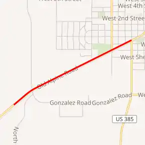
Spur 194 highlighted in red | ||||
| Route information | ||||
| Maintained by TxDOT | ||||
| Length | 1.352 mi[1] (2.176 km) | |||
| Existed | 1946[1]–present | |||
| Major junctions | ||||
| South end | ||||
| North end | ||||
| Location | ||||
| Counties | Pecos | |||
| Highway system | ||||
| ||||
Route description
Spur 194, known as Railroad Avenue within the city of Fort Stockton and Old Alpine Road (proposed FM 3531) beyond, begins at a point southwest of Fort Stockton where TxDOT takes over maintenance of the former highway to Alpine from the county. The route begins as a two-lane road, then becomes a five-lane road with a center left-turn lane just outside the city limits. The spur follows to the northeast along the north side of the South Orient Rail Line before ending at US 385.[2][3]
History
Most of Spur 194 follows the original alignment of US 67 between Fort Stockton and Alpine along Old Alpine Road from 1932[4] until the current US 67 roadway was constructed to the west sometime after 1940[5] and before the creation of the spur.
Spur 194 was designated on December 10, 1946 following a longer 2.0-mile (3.2 km) route that began at its present southern terminus at a former stockyard near a railroad crossing and extended further along the present US 385 terminating at what was then US 290 and now Business Interstate 10-G.[1] In 1949, the stretch of the current US 385 south of US 290 was designated as Farm to Market Road 1214 (FM 1214) over a route that eventually was extended to Marathon.[6] On October 24, 1956, FM 1214 was incorporated into a southern extension of State Highway 51 (SH 51)[7] On August 28, 1958, SH 51 was cancelled and changed to US 385,[8] and Spur 194 was truncated to avoid a dual designation over US 385 on December 10, 1959.[1]
Major intersections
The entire route is in Pecos County. [2]
| Location[2] | mi[1] | km | Destinations | Notes | |
|---|---|---|---|---|---|
| | 0.0 | 0.0 | Old Alpine Road | Southern terminus | |
| Fort Stockton | 1.4 | 2.3 | Northern terminus | ||
| 1.000 mi = 1.609 km; 1.000 km = 0.621 mi | |||||
See also
 U.S. Roads portal
 Texas portal
References
- Transportation Planning and Programming Division (n.d.). "State Highway Spur No. 194". Highway Designation Files. Texas Department of Transportation. Retrieved April 6, 2012.
- Transportation Planning and Programming Division (2012). Texas County Mapbook (PDF) (Map) (2012 ed.). 1:120,000. Texas Department of Transportation. p. 146. OCLC 867856197. Retrieved April 6, 2012.
- Google (April 6, 2012). "Satellite view of Spur 194" (Map). Google Maps. Google. Retrieved April 6, 2012.
- Transportation Planning and Programming Division (n.d.). "U.S. Highway No. 67". Highway Designation Files. Texas Department of Transportation. Retrieved April 6, 2012.
- General Highway Map, Pecos County, Texas (Map) (1936 ed.). 1 in=2 mi. Texas State Highway Department. Partially revised to February 1, 1940. p. 1. Retrieved April 6, 2012. Check date values in:
|date=(help) - Transportation Planning and Programming Division (n.d.). "Farm to Market Road No. 1214". Highway Designation Files. Texas Department of Transportation. Retrieved April 6, 2012.
- Transportation Planning and Programming Division (n.d.). "State Highway No. 51". Highway Designation Files. Texas Department of Transportation. Retrieved April 6, 2012.
- Transportation Planning and Programming Division (n.d.). "U.S. Highway No. 385". Highway Designation Files. Texas Department of Transportation. Retrieved April 6, 2012.
External links
 Geographic data related to State Highway Spur 194 at OpenStreetMap
