Thattamala
Thattamala is a neighbourhood situated at the southeast border of Kollam city in state of Kerala, India. It is situated at National Highways – NH 66 (Earlier NH 47). Kerala Police have identified Thattamala as one of the traffic black spots in the state.[1]
Thattamala | |
|---|---|
Neighbourhood | |
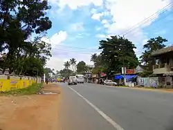 National Highway-66 at Thattamala | |
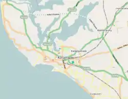 Thattamala Location in Kollam, India  Thattamala Thattamala (Kerala)  Thattamala Thattamala (India) | |
| Coordinates: 8.871725°N 76.639020°E | |
| Country | |
| City | Kollam |
| Zone | Eravipuram |
| Government | |
| • Body | Kollam Municipal Corporation(KMC) |
| Languages | |
| • Official | Malayalam, English |
| Time zone | UTC+5:30 (IST) |
| PIN | 691020 |
| Vehicle registration | KL-02 |
| Lok Sabha constituency | Kollam |
| Civic agency | Kollam Municipal Corporation |
| Avg. summer temperature | 34 °C (93 °F) |
| Avg. winter temperature | 22 °C (72 °F) |
| Website | http://www.kollam.nic.in |
Thattamala was a part of old Vadakkevila panchayath before the constitution of Kollam as a city. In 2000, Kollam was upgraded by the Government of Kerala as the 4th Municipal Corporation of Kerala by merging Vadakkevila, Kilikollur, Sakthikulangara and Eravipuram panchayaths with Kollam Municipality.[2]
Major Public/Private Institutions near Thattamala
- Travancore Medicity Medical College Hospital
- vadakkevila service co operative bank
- (Thayyil Finance) Thattamala branch
- Canara Bank Thattamala branch
- Govt. LP School, Eravipuram
- Sarathy Bajaj
- KTM Kollam
- Popular Megamotors
- Sree Narayana Public School[3]
- Dimos Furniture
- Damro Furniture
- Himalaya Chitty Limited[4]
See also
References
- State roads strewn with ‘black spots' - The Hindu
- "Archived copy" (PDF). Archived from the original (PDF) on 14 July 2014. Retrieved 13 December 2015.CS1 maint: archived copy as title (link) Rapid Baseline Assessment in Kollam City
- Sree Narayana Public School, Kollam
- Plea to allow chitty fund to function
| City Corporations |  | ||||||||||||
|---|---|---|---|---|---|---|---|---|---|---|---|---|---|
| Municipalities | |||||||||||||
| Revenue Divisional Office | |||||||||||||
| Talukas and villages |
| ||||||||||||
This article is issued from Wikipedia. The text is licensed under Creative Commons - Attribution - Sharealike. Additional terms may apply for the media files.